
Dewey–Humboldt is a town in Yavapai County, Arizona, United States. The population of the town was 3,894 according to the 2010 census. The Dewey–Humboldt area was a census-designated place (CDP) at the 2000 census, at which time its population was 6,295.

The New Zealand Wars took place from 1845 to 1872 between the New Zealand colonial government and allied Māori on one side, and Māori and Māori-allied settlers on the other. They were previously commonly referred to as the Land Wars or the Māori Wars, while Māori language names for the conflicts included Ngā pakanga o Aotearoa and Te riri Pākehā. Historian James Belich popularised the name "New Zealand Wars" in the 1980s, although according to Vincent O'Malley, the term was first used by historian James Cowan in the 1920s.

The Invasion of the Waikato became the largest and most important campaign of the 19th-century New Zealand Wars. Hostilities took place in the North Island of New Zealand between the military forces of the colonial government and a federation of Māori tribes known as the Kingitanga Movement. The Waikato is a territorial region with a northern boundary somewhat south of the present-day city of Auckland. The campaign lasted for nine months, from July 1863 to April 1864. The invasion was aimed at crushing Kingite power and also at driving Waikato Māori from their territory in readiness for occupation and settlement by European colonists. The campaign was fought by a peak of about 14,000 Imperial and colonial troops and about 4,000 Māori warriors drawn from more than half the major North Island tribal groups.
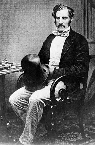
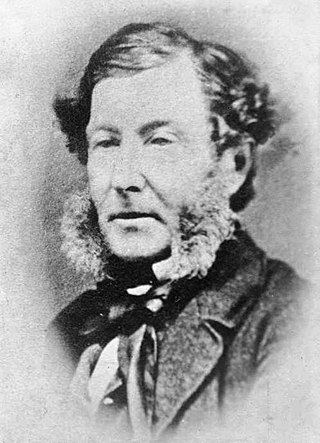
Sir George Grey, KCB was a British soldier, explorer, colonial administrator and writer. He served in a succession of governing positions: Governor of South Australia, twice Governor of New Zealand, Governor of Cape Colony, and the 11th premier of New Zealand. He played a key role in the colonisation of New Zealand, and both the purchase and annexation of Māori land.
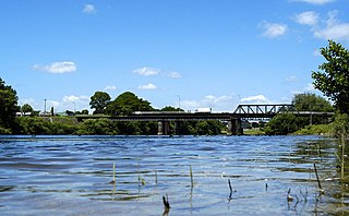
Ngāruawāhia is a town in the Waikato region of the North Island of New Zealand. It is located 20 kilometres (12 mi) north-west of Hamilton at the confluence of the Waikato and Waipā Rivers, adjacent to the Hakarimata Range. Ngāruawāhia is in the Hamilton Urban Area, the fourth largest urban area in New Zealand. The location was once considered as a potential capital of New Zealand.

KīngiTāwhiao, known initially as Matutaera, reigned as the Māori King from 1860 until his death. After his flight to the King Country, Tāwhiao was also Paramount Chief of the Rohe Pōtae for 17 years, until 1881. A Waikato Tainui nobleman, rangatira, and religious figure, Tāwhiao amassed power and authority during a time of momentous change to become de facto leader of the Waikato tribes. He was a member of the Ngati Mahuta hapū, who comprise the kāhui ariki.
Warkworth is a town on the Northland Peninsula in the upper North Island of New Zealand. It is in the northern part of the Auckland Region. It is located on State Highway 1, 64 km (40 mi) north of Auckland and 98 km (61 mi) south of Whangārei, and is at the head of Mahurangi Harbour.

South Auckland ) is one of the major geographical regions of Auckland, the largest city in New Zealand. The area is south of the Auckland isthmus, and on the eastern shores of the Manukau Harbour. The area has been populated by Tāmaki Māori since at least the 14th century, and has important archaeological sites, such as the Ōtuataua stonefield gardens at Ihumātao, and Māngere Mountain, a former pā site important to Waiohua tribes.
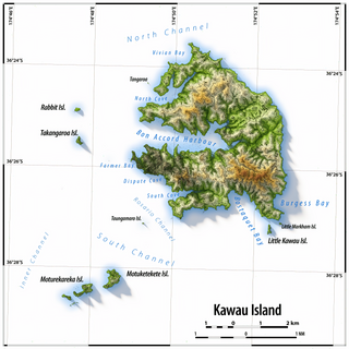
Kawau Island is in the Hauraki Gulf, close to the north-eastern coast of the North Island of New Zealand. At its closest point it lies 1.4 km (0.87 mi) off the coast of the Northland Peninsula, just south of Tāwharanui Peninsula, and about 8 km (5.0 mi) by sea journey from Sandspit Wharf, and shelters Kawau Bay to the north-east of Warkworth. It is 40 km (25 mi) north of Auckland. Mansion House in the Kawau Island Historic Reserve is an important historic tourist attraction. Almost every property on the Island relies on direct access to the sea. There are only two short roads serving settlements at Schoolhouse Bay and South Cove, and most residents have private wharves for access to their front door steps.

Old New-Gate Prison is a former prison and mine site on New-Gate Road in East Granby, Connecticut. It is now operated by the state of Connecticut as the Old New-Gate Prison & Copper Mine Archaeological Preserve. Previously closed for restoration since 2009, it was re-opened on July 14, 2018. The site includes a colonial-era copper mine, which visitors are able to explore through a guided tour, and the remains of the state's first official prison, which was used between 1776 and 1782 to house prisoners of war from the American Revolutionary War. The site was designated a National Historic Landmark in 1972.
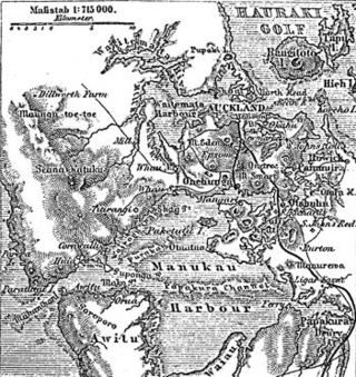
The human history of the Auckland metropolitan area stretches from early Māori settlers in the 14th century to the first European explorers in the late 18th century, over a short stretch as the official capital of (European-settled) New Zealand in the middle of the 19th century to its current position as the fastest-growing and commercially dominating metropolis of the country.
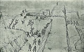
The Battle of Rangiriri was a major engagement in the invasion of Waikato, which took place on 20–21 November 1863 during the New Zealand Wars. More than 1400 British troops defeated about 500 warriors of the Kingitanga, which was resisting the expansion of British settlement and colonial rule in the North Island. The battle cost both sides more than any other engagement of the land wars and also resulted in the capture of 180 Māori prisoners, further reducing the Kingitanga ability to oppose the far larger British force.
Marmaduke George Nixon was a soldier in the New Zealand Wars. Born at Malta, he joined the British Army in 1831, spending most of his career as an officer in British India with the 39th Regiment of Foot. He left the British Army in 1851 and shortly afterwards emigrated to New Zealand to take up farming in South Auckland. In 1860, during one of the main phases of the New Zealand Wars, he formed and led a cavalry unit in defence of South Auckland. He later participated in the Invasion of the Waikato as commander of Nixon's Horse, another cavalry unit. He was one of the highest ranking casualties of the New Zealand Wars when he died on 27 May 1864 from wounds received in an attack earlier in the year on a village at Rangiaowhia. He was also a Member of Parliament, representing the largely rural electorate of Franklin from 1861 up until his death.

Scandrett Regional Park is a regional park located on the north east tip of the Mahurangi Peninsula, north of the city of Auckland, New Zealand. It encompasses Mullet Point and includes regenerating coastal forest, rocky headlands that protrude into Kawau Bay, Scandretts Bay beach and a precinct of historic farm buildings. The people of Auckland own the park through the Auckland Council.

Mansion House on Kawau Island, New Zealand, is a house that was owned by Sir George Grey from 1862 to 1888. Built in 1845 as the house for the manager of a copper mine on the island, it was extended significantly by Grey during his ownership. Mansion House is a heritage listed building. It is open to the public as part of the Kawau Island Historic Reserve administered by the Department of Conservation.

The Pumphouse ruins on Kawau Island, New Zealand, belong to the copper mine established in 1844. The mine had ongoing problems, including legal, mismanagement, and flooding. To address the latter issue, a pumphouse was built in 1854. The ruins were registered by the New Zealand Historic Places Trust on 23 June 1983 with registration number 9. The ruins have a category I listing.
Yelta is a rural locality at the northern end of the Yorke Peninsula and a satellite village to the town of Moonta, centred on the former Yelta Mine. It is located in the Copper Coast Council. The modern locality was established when the name and boundaries were selected in January 1999.

Rangiaowhia was, for over 20 years, a thriving village on a ridge between two streams in the Waikato region, about 4 km (2.5 mi) east of Te Awamutu. From 1841 it was the site of a very productive Māori mission station until the Invasion of the Waikato in 1864. The station served Ngāti Hinetu and Ngāti Apakura. Only a church remains from those days, the second oldest Waikato building.
Coopers Creek is a locality and mine in the Gippsland region of Victoria, Australia. In the 1860s, Coopers Creek was settled during the Victorian gold rush and, throughout its history, gold, copper and lime have been mined there. Today, Coopers Creek is effectively limited to two camping sites, the first near the site of the mining town and the second to the east at Bruntons Bridge. Ruins from the locality's mining history, and the Copper Mine Hotel are all of the locality's history which survives. In August 2022, the 21 properties that comprise the town were listed for sale.

