Great Barrier Island lies in the outer Hauraki Gulf, New Zealand, 100 kilometres (62 mi) north-east of central Auckland. With an area of 285 square kilometres (110 sq mi) it is the sixth-largest island of New Zealand and fourth-largest in the main chain. Its highest point, Mount Hobson, is 627 metres (2,057 ft) above sea level. The local authority is the Auckland Council.

Waiheke Island is the second-largest island in the Hauraki Gulf of New Zealand. Its ferry terminal in Matiatia Bay at the western end is 21.5 km (13.4 mi) from the central-city terminal in Auckland.

Tiritiri Matangi Island is located in the Hauraki Gulf of New Zealand, 3.4 km (2.1 mi) east of the Whangaparāoa Peninsula in the North Island and 30 km (19 mi) north east of Auckland. The 2.2 km2 (1 sq mi) island is an open nature reserve managed by the Supporters of Tiritiri Matangi Incorporated, under the supervision of the Department of Conservation and is noted for its bird life, including takahē, North Island kōkako and kiwi. It attracts between 30,000 and 32,000 visitors a year, the latter figure being the maximum allowed by the Auckland Conservation Management Strategy.

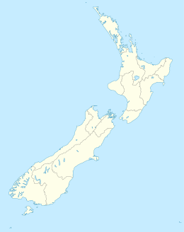
The Hauraki Gulf / Tīkapa Moana is a coastal feature of the North Island of New Zealand. It has an area of 4000 km2, and lies between, in anticlockwise order, the Auckland Region, the Hauraki Plains, the Coromandel Peninsula, and Great Barrier Island. Most of the gulf is part of the Hauraki Gulf Marine Park.

Waitematā Harbour is the main access by sea to Auckland, New Zealand. For this reason it is often referred to as Auckland Harbour, despite the fact that it is one of two harbours adjoining the city. The harbour forms the northern and eastern coasts of the Auckland isthmus and is crossed by the Auckland Harbour Bridge. It is matched on the southern side of the city by the shallower waters of the Manukau Harbour.

Little Barrier Island, or Hauturu in Māori, lies off the northeastern coast of New Zealand's North Island. Located 80 kilometres (50 mi) to the north of Auckland, the island is separated from the mainland to the west by Jellicoe Channel, and from the larger Great Barrier Island to the east by Cradock Channel. The two aptly named islands shelter the Hauraki Gulf from many of the storms of the Pacific Ocean.
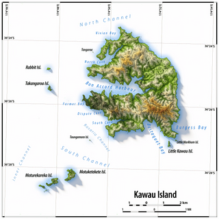
Kawau Island is in the Hauraki Gulf, close to the north-eastern coast of the North Island of New Zealand. At its closest point it lies 1.4 km (0.87 mi) off the coast of the Northland Peninsula, just south of Tāwharanui Peninsula, and about 8 km (5.0 mi) by sea journey from Sandspit Wharf, and shelters Kawau Bay to the north-east of Warkworth. It is 40 km (25 mi) north of Auckland. Mansion House in the Kawau Island Historic Reserve is an important historic tourist attraction. Almost every property on the Island relies on direct access to the sea. There are only two short roads serving settlements at Schoolhouse Bay and South Cove, and most residents have private wharves for access to their front door steps.

The Hen and Chicken Islands lie to the east of the North Auckland Peninsula off the coast of northern New Zealand. They lie 12 kilometres (7.5 mi) east of Bream Head and 40 kilometres (25 mi) south-east of Whangārei with a total area of 8.44 km2 (3.26 sq mi).

Motukorea or Browns Island is a small New Zealand island, in the Hauraki Gulf north of Musick Point, one of the best preserved volcanoes in the Auckland volcanic field. The age of eruption is about 25,000 years ago, when the Tāmaki Estuary and the Waitemata Harbour were forested river valleys. Due to centuries of cultivation, little native bush remains except on the north-eastern cliffs, leaving the volcanic landforms easily visible. It exhibits the landforms from three styles of eruption. The island consists of one main scoria cone with a deep crater, a small remnant arc of the tuff ring forming the cliffs in the northeast, and the upper portions of lava flows. The area was dry land when the eruptions occurred, but much of the lava is now submerged beneath the sea.
The human history of the Auckland metropolitan area stretches from early Māori settlers in the 14th century to the first European explorers in the late 18th century, over a short stretch as the official capital of (European-settled) New Zealand in the middle of the 19th century to its current position as the fastest-growing and commercially dominating metropolis of the country.
Pākiri is a locality in Auckland, in the former Rodney District of New Zealand. Leigh is about 9 kilometres (6 mi) to the south-east. The Pākiri River flows through the area and into the Hauraki Gulf / Tīkapa Moana to the north-east.

Tāwharanui Peninsula is a finger of land projecting into the Hauraki Gulf from the east coast of the much larger North Auckland Peninsula of New Zealand. It separates Ōmaha Bay to the north from Kawau Bay and Kawau Island to the south. The nearest sizable town is Warkworth.

French Pass is a narrow and treacherous stretch of water that separates D'Urville Island, at the north end of the South Island of New Zealand, from the mainland coast. At one end is Tasman Bay, and at the other end the outer Pelorus Sound / Te Hoiere leads out to Cook Strait.

Moturekareka Island is a small island off the southern edge of Kawau Island in Auckland's Hauraki Gulf, approximately 43.7 km north of Auckland. It is separated from nearby Motuketekete Island by Blanche Channel.
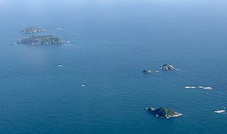
The Noises are a collection of islands lying northeast of Rakino Island in Auckland's Hauraki Gulf, off the coast of the North Island of New Zealand. The largest and most forested islands are Ōtata and Motuhoropapa; Orarapa and Maria/Ruapuke are also significant. After a rat eradication campaign in the 1960s, Maria was the first New Zealand island to become predator-free. The lack of invasive predators, intact native forest, and large numbers of breeding seabirds give the Noises significant conservation value. There has however been a marked decline in marine biodiversity surrounding the islands from over-fishing.

Shakespear Regional Park is a nature park in the Auckland Region of New Zealand. It is located at the tip of the Whangaparaoa Peninsula, and is named after the Shakespear family which bought the land in the 1880s from local Maori.

Scandrett Regional Park is a regional park located on the north east tip of the Mahurangi Peninsula, north of the city of Auckland, New Zealand. It encompasses Mullet Point and includes regenerating coastal forest, rocky headlands that protrude into Kawau Bay, Scandretts Bay beach and a precinct of historic farm buildings. The people of Auckland own the park through the Auckland Council.

Mansion House on Kawau Island, New Zealand, is a house that was owned by Sir George Grey from 1862 to 1888. Built in 1845 as the house for the manager of a copper mine on the island, it was extended significantly by Grey during his ownership. Mansion House is a heritage listed building. It is open to the public as part of the Kawau Island Historic Reserve administered by the Department of Conservation.

Ngāti Whātua Ōrākei or Ngāti Whātua-o-Ōrākei is an Auckland-based Māori hapū (sub-tribe) in New Zealand. Together with Te Uri-o-Hau, Te Roroa and Te Taoū, it comprises the iwi (tribe) of Ngāti Whātua. These four hapū can act together or separately as independent tribes. The hapū's rohe is mostly in Tāmaki Makaurau, the site of present-day Auckland. Ngāti Whātua Ōrākei has around 6,000 members whose collective affairs are managed by the Ngāti Whātua Ōrākei Trust.
Mahurangi Harbour is a natural harbour in New Zealand. It is located on the north-eastern coast of the Auckland Region near the town of Warkworth, and empties into the Hauraki Gulf.