Great Barrier Island lies in the outer Hauraki Gulf, New Zealand, 100 kilometres (62 mi) north-east of central Auckland. With an area of 285 square kilometres (110 sq mi) it is the sixth-largest island of New Zealand and fourth-largest in the main chain. Its highest point, Mount Hobson, is 627 metres (2,057 ft) above sea level. The local authority is the Auckland Council.

The Hauraki Gulf / Tīkapa Moana is a coastal feature of the North Island of New Zealand. It has an area of 4000 km2, and lies between, in anticlockwise order, the Auckland Region, the Hauraki Plains, the Coromandel Peninsula, and Great Barrier Island. Most of the gulf is part of the Hauraki Gulf Marine Park.

Waitematā Harbour is the main access by sea to Auckland, New Zealand. For this reason it is often referred to as Auckland Harbour, despite the fact that it is one of two harbours adjoining the city. The harbour forms the northern and eastern coasts of the Auckland isthmus and is crossed by the Auckland Harbour Bridge. It is matched on the southern side of the city by the shallower waters of the Manukau Harbour.

The Mercury Islands are a group of seven islands off the northeast coast of New Zealand's North Island. They are located 8 kilometres (5 mi) off the coast of the Coromandel Peninsula, and 35 kilometres (22 mi) northeast of the town of Whitianga.

The Cradock Channel is one of three channels connecting the Hauraki Gulf with the Pacific Ocean to the northeast of Auckland, New Zealand. It is the central channel, lying between Great Barrier Island to the east and Little Barrier Island to the west. The other two channels are the Jellicoe Channel and the Colville Channel.

Little Barrier Island, or Hauturu in Māori language, lies off the northeastern coast of New Zealand's North Island. Located 80 kilometres (50 mi) to the north of Auckland, the island is separated from the mainland to the west by Jellicoe Channel, and from the larger Great Barrier Island to the east by Cradock Channel. The two aptly named islands shelter the Hauraki Gulf from many of the storms of the Pacific Ocean.

Motukorea or Browns Island is a small New Zealand island, in the Hauraki Gulf north of Musick Point, one of the best preserved volcanoes in the Auckland volcanic field. The age of eruption is about 25,000 years ago, when the Tāmaki Estuary and the Waitemata Harbour were forested river valleys. Due to centuries of cultivation, little native bush remains except on the north-eastern cliffs, leaving the volcanic landforms easily visible. It exhibits the landforms from three styles of eruption. The island consists of one main scoria cone with a deep crater, a small remnant arc of the tuff ring forming the cliffs in the northeast, and the upper portions of lava flows. The area was dry land when the eruptions occurred, but much of the lava is now submerged beneath the sea.
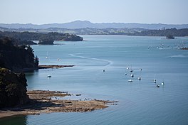
The Mahurangi River in northern New Zealand flows through the town of Warkworth and into Mahurangi Harbour, which opens into the outer Hauraki Gulf. The Left Branch of the river rises in the Dome and flows through the Dome Valley, while the Right Branch rises on Moir Hill. The lower part is a tidal estuary that ranges in depth from below approximately 50 centimetres at the channel entrance to approximately 150 centimetres further upstream. The Mahurangi Harbour provides a sheltered anchorage for private pleasure craft in all weathers.

The Auckland isthmus, also known as the Tāmaki isthmus, is a narrow stretch of land on the North Island of New Zealand in the Auckland Region, and the location of the central suburbs of the city of Auckland, including the CBD. The isthmus is located between two rias, the Waitematā Harbour to the north, which opens to the Hauraki Gulf / Tīkapa Moana and Pacific Ocean, and the Manukau Harbour to the south, which opens to the Tasman Sea. The isthmus is the most southern section of the Northland Peninsula.
Pakiri is a locality in Auckland, in the former Rodney District of New Zealand. Leigh is about 9 kilometres (6 mi) to the south-east. The Pakiri River flows through the area and into the Hauraki Gulf to the north-east.

The Wairoa River, also known as Wairoa South, is the second longest river in the Auckland Region of New Zealand's North Island. It flows north from its sources in the Hunua Ranges into the Hauraki Gulf, and passes adjacent to the township of Clevedon. The Hunua Falls form a section of the river.
Ngāti Pāoa is a Māori iwi (tribe) that has extensive links to the Hauraki and Waikato tribes of New Zealand. Its traditional lands stretch from the western side of the Hauraki Plains to Auckland. They also settled on Hauraki Gulf islands such as Waiheke.
The Auckland Region of New Zealand is built on a basement of greywacke rocks that form many of the islands in the Hauraki Gulf, the Hunua Ranges, and land south of Port Waikato. The Waitākere Ranges in the west are the remains of a large andesitic volcano, and Great Barrier Island was formed by the northern end of the Coromandel Volcanic Zone. The Auckland isthmus and North Shore are composed of Waitemata sandstone and mudstone, and portions of the Northland Allochthon extend as far south as Albany. Little Barrier Island was formed by a relatively isolated andesitic volcano, active around 1 to 3 million years ago.

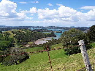
Scandrett Regional Park is a regional park located on the north east tip of the Mahurangi Peninsula, north of the city of Auckland, New Zealand. It encompasses Mullet Point and includes regenerating coastal forest, rocky headlands that protrude into Kawau Bay, Scandretts Bay beach and a precinct of historic farm buildings. The total area of land is 44.4 hectares or 100 acres. The people of Auckland own the park through the Auckland Council.

Tāmaki Māori are Māori iwi and hapū who have a strong connection to Tāmaki Makaurau, and whose rohe was traditionally within the region. Among Ngā Mana Whenua o Tāmaki Makaurau, also known as the Tāmaki Collective, there are thirteen iwi and hapū, organised into three rōpū (collectives), however Tāmaki Māori can also refer to subtribes and historical iwi not included in this list.

Te Toiokawharu is a hill in the Waitākere Ranges of the Auckland Region of New Zealand's North Island. At 474-metres, it is the tallest peak of the Waitākere Ranges. The peak has a low prominence due to surrounding hills of similar sizes.

Motuketekete Island is an uninhabited island in the northern Hauraki Gulf, off the northeastern coast of New Zealand's North Island. It is separated from Moturekareka Island to the west by the Blanche Channel.

West Auckland is one of the major geographical areas of Auckland, the largest city in New Zealand. Much of the area is dominated by the Waitākere Ranges, the eastern slopes of the Miocene era Waitākere volcano which was upraised from the ocean floor, and one of the largest regional parks in New Zealand. The metropolitan area of West Auckland developed on the lands between the Waitākere Ranges to the west and the upper reaches of the Waitematā Harbour to the east, in areas such as Massey, Henderson, New Lynn and Glen Eden.

The Big Muddy Creek is an estuarine tidal inlet of the Auckland Region of New Zealand's North Island. It flows south from its tributary rivers, the Nihotupu Stream and the Island stream in the Waitākere Ranges which are dammed at the Lower Nihotupu Reservoir, towards the Manukau Harbour.

The Whangateau Harbour is a natural harbour in New Zealand. It is a sandspit estuary, located on the north-eastern coast of the Auckland Region north-east of Matakana, and empties into the Hauraki Gulf. Due to the harbour's high quality water and dense shellfish beds, the harbour is a popular spot for shellfish gathering.