Early history of Maori tells how the western shores of Okahukura once extended to the entrance of the Kaipara Harbour as sand dunes with two channels into the harbour instead of one, as it is now. This portion of land that was more or less sand dunes was known as Tapora, and was inhabited by the Maori. Great storms gradually caused the sand dunes to drift away, allowing the sea to encroach, leaving only sand bars in the harbour where there was once a whare or large temple on the original sand dunes.
The name Okahukura refers to Kahukura, one of the rangatira who arrived to New Zealand aboard the Tākitimu migratory waka.[3]
For ten generations the land of Okahukura remained in the possession of Ngati Whatua. For more than ten years after the Government had purchased the neighbouring land known as Albertland, the peninsula was occupied by the Ngati Whatua tribe.
About the year 1876 T. E. FitzGerald purchased the land from Ngati Whatua which included the Okahukura point and 24,000 acres (97km2) of land. FitzGerald built his first homestead around 1880 on a ridge overlooking Oruawharo River. Here he built a jetty for small boats for access when there was sufficient high tide, but there was a main landing point in deeper water for any tide. Due to the large number of kauri trees, FitzGerald leased the rights of this land to gum-diggers. Due to old age FitzGerald had to retire and terminate his twenty years of occupancy at Okahukura.
Following FitzGerald's retirement A. H. Walker leased this land for two and a half years and dramatically changed the landscape by re-fencing and sowing grass. T.C. Williams now leased the land with W. Williams taking over management. For the next ten years Williams and his workers spent many days cutting and burning down bush to allow for sowing grasslands, while opening gumfields and a store at one of FitzGerald's old homes. In the year 1910 Williams was in the process of transferring the management of the block to C. Kemp, when he accidentally fatally shot himself. Kemp took over management of Okahukura, continuing with the development of boundary fences. Nearer the end of 1910 Okahukura was sold to Messrs Bowron and Smith of Christchurch. Kemp was still manager of the Okahukura property and split the property up, selling sections to others and developed roads for access into the new sections as well as communications through a telephone line. The land changed ownership numerous times between World War One and World War Two.
Recent history
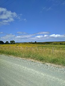
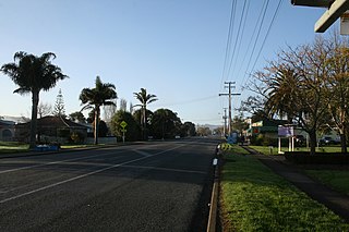
Farm scene from Okahukura Road, TaporaOkahukura Road near the Junction with Journey's End, Tapora
During World War Two the United States Marines set up camp on 'the run' (Sea View) and used the greater area for target practice. The New Zealand Government then took over Okahukura to use as a soldier rehabilitation settlement in April 1945. The name Okahukura was then changed to Tapora to avoid confusion with another Okahukura elsewhere in New Zealand.
The Minister of 'Land and Returned Services' Association brokered a pact to develop the Okahukura peninsula for returned servicemen through ballots. A community to be called Tapora was planned with a shop, school, church and workers' houses (only the school and a few houses were constructed).[4] The ballots for the Returned Services' Association were created in 1947 and Tapora turned into a dairy farming settlement.
In 2013 a substantial fire which began near Okahukura Road burned through 85ha of land at Tapora, much of it wild pines, Gorse, Pampas Grass and coastal scrub/conservation land.[6][7][8]
In recent years, many of the Dairy Farms in Tapora were converted to Orchards, with tens of thousands of Avocado Trees planted.[9][10][11]
Demographics
Tapora is in an SA1 statistical area which also includes Birds Beach and covers 42.72km2 (16.49sqmi).[12] The SA1 area is part of the larger Okahukura Peninsula statistical area.
The SA1 statistical area had a population of 123 at the 2018 New Zealand census, an increase of 9 people (7.9%) since the 2013 census, and an increase of 6 people (5.1%) since the 2006 census. There were 36 households, comprising 66 males and 57 females, giving a sex ratio of 1.16 males per female. The median age was 35.2 years (compared with 37.4 years nationally), with 27 people (22.0%) aged under 15 years, 24 (19.5%) aged 15 to 29, 54 (43.9%) aged 30 to 64, and 15 (12.2%) aged 65 or older.
Ethnicities were 80.5% European/Pākehā, 31.7% Māori, 4.9% Pacific peoples, and 2.4% Asian. People may identify with more than one ethnicity.
Although some people chose not to answer the census's question about religious affiliation, 63.4% had no religion, 24.4% were Christian and 2.4% had other religions.
Of those at least 15 years old, 3 (3.1%) people had a bachelor's or higher degree, and 27 (28.1%) people had no formal qualifications. The median income was $31,400, compared with $31,800 nationally. 12 people (12.5%) earned over $70,000 compared to 17.2% nationally. The employment status of those at least 15 was that 48 (50.0%) people were employed full-time, 12 (12.5%) were part-time, and 3 (3.1%) were unemployed.[13]
Okahukura Peninsula
Okahukura Peninsula statistical area, which includes Port Albert and Te Hana, covers 211.18km2 (81.54sqmi)[12] and had an estimated population of 1,680 as of June 2022,[14] with a population density of 8.0 people per km2.
Okahukura Peninsula had a population of 1,491 at the 2018 New Zealand census, an increase of 132 people (9.7%) since the 2013 census, and an increase of 111 people (8.0%) since the 2006 census. There were 522 households, comprising 777 males and 714 females, giving a sex ratio of 1.09 males per female. The median age was 41.7 years (compared with 37.4 years nationally), with 306 people (20.5%) aged under 15 years, 234 (15.7%) aged 15 to 29, 732 (49.1%) aged 30 to 64, and 216 (14.5%) aged 65 or older.
Ethnicities were 88.3% European/Pākehā, 20.5% Māori, 3.2% Pacific peoples, 3.2% Asian, and 1.0% other ethnicities. People may identify with more than one ethnicity.
The percentage of people born overseas was 15.9, compared with 27.1% nationally.
Although some people chose not to answer the census's question about religious affiliation, 56.9% had no religion, 31.0% were Christian, 0.8% had Māori religious beliefs, 0.6% were Hindu, 0.2% were Muslim and 1.2% had other religions.
Of those at least 15 years old, 141 (11.9%) people had a bachelor's or higher degree, and 225 (19.0%) people had no formal qualifications. The median income was $32,600, compared with $31,800 nationally. 162 people (13.7%) earned over $70,000 compared to 17.2% nationally. The employment status of those at least 15 was that 639 (53.9%) people were employed full-time, 198 (16.7%) were part-time, and 39 (3.3%) were unemployed.[15]
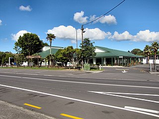
Tapora Reserve (playground, seating and Tennis Courts)
Tapora School
Education
Tapora School is a coeducational full primary (years 1-8) school[16] with a roll of 10[17] as of February 2023.[17] The school was founded in 1956.[18]
Notes
↑ Peter Dowling, ed. (2004). Reed New Zealand Atlas. Reed Books. pp.map 10. ISBN0-7900-0952-8.
↑ Roger Smith, GeographX (2005). The Geographic Atlas of New Zealand. Robbie Burton. pp.map 30. ISBN1-877333-20-4.
↑ Cameron, Ewen; Hayward, Bruce; Murdoch, Graeme (2008). A Field Guide to Auckland: Exploring the Region's Natural and Historical Heritage. Random House New Zealand. p.100. ISBN978-1-86962-1513.
Waitematā Harbour is the main access by sea to Auckland, New Zealand. For this reason it is often referred to as Auckland Harbour, despite the fact that it is one of two harbours adjoining the city. The harbour forms the northern and eastern coasts of the Auckland isthmus and is crossed by the Auckland Harbour Bridge. It is matched on the southern side of the city by the shallower waters of the Manukau Harbour.
Ōrākei is a suburb of Auckland city, in the North Island of New Zealand. It is located on a peninsula five kilometres to the east of the city centre, on the shore of the Waitematā Harbour, which lies to the north, and Hobson Bay and Ōrākei Basin, two arms of the Waitematā, which lie to the west and south. To the east is the suburb of Mission Bay. Takaparawhau / Bastion Point is a coastal piece of land in Ōrākei. Between Takaparawhau and Paritai Drive is Ōkahu Bay and Reserve.
Panmure is an east Auckland suburb, in the North Island of New Zealand. It is located 11 kilometres southeast of the Auckland CBD, close to the western banks of the Tāmaki River and the northern shore of the Panmure Basin. To the north lies the suburb of Tāmaki, and to the west is the cone of Maungarei / Mount Wellington.
Māngere is a major suburb in South Auckland, New Zealand, located on mainly flat land on the northeastern shore of the Manukau Harbour, to the northwest of Manukau City Centre and 15 kilometres south of the Auckland city centre. It is the location of Auckland Airport, which lies close to the harbour's edge to the south of the suburb.
Muriwai, also called Muriwai Beach, is a coastal community on the west coast of the Auckland Region in the North Island of New Zealand. The black-sand surf beach and surrounding area is a popular recreational area for Aucklanders. The Muriwai Regional Park includes a nesting site for a large colony of gannets.
Kumeū is an affluent rural town and suburb of Auckland situated 25 km north-west of the City Centre in New Zealand. State Highway 16 and the North Auckland Line pass through the town. Huapai lies to the west, Riverhead to the north, Whenuapai to the east, and Taupaki to the south.
Helensville is a town in the North Island of New Zealand. It is sited 40 kilometres (25 mi) northwest of Auckland, close to the southern extremity of the Kaipara Harbour. State Highway 16 passes through the town, connecting it to Waimauku 16 kilometres (10 mi) to the south, and Kaukapakapa about 12 kilometres (7.5 mi) to the north-east. Parakai is two kilometres (1.2 mi) to the north-west.
Wellsford is a town on the Northland Peninsula in the northern North Island of New Zealand. It is the northernmost major settlement in the Auckland Region, and is 77 kilometres northwest of the Auckland CBD.
Parakai is a town in the North Island of New Zealand, sited 43 kilometres northwest of Auckland, close to the southern extremity of the Kaipara Harbour. Helensville is about 3 km (1.9 mi) to the south-east, and Waioneke is 22 km (14 mi) to the north-west.
Waikowhai is an Auckland suburb, under the local governance of the Auckland Council. Waikowhai has the largest block of native forest left on the Auckland isthmus. The block was considered the too infertile for farming and subsequently not cleared but given to the Wesley Mission. Today the forest block hosts a valuable sample of Auckland's original fauna and flora. Waikōwhai Walkway extends for 10 km (6.2 mi) linking Onehunga to Lynfield Cove.
Owairaka is a suburb of New Zealand's largest city, Auckland. It is under the local governance of the Auckland Council. The area was primarily rural until the 1930s, when the area experienced suburban growth. Owairaka is known for the Owairaka Athletic Club, a club that came to prominence in the 1960s, due to the success of coach Arthur Lydiard and athletes Murray Halberg and Peter Snell.
Waimauku is a small locality in the Auckland Region of New Zealand. It comes under the jurisdiction of Auckland Council, and is in the council's Rodney ward. Waimauku is approximately 4 kilometres west of Huapai on State Highway 16 at the junction with the road to Muriwai Beach. Helensville is 16 km to the north-west. Waimauku is a Māori word which is literally translated as wai: stream and mauku: varieties of small ferns.
Tāwharanui Peninsula is a finger of land projecting into the Hauraki Gulf from the east coast of the much larger North Auckland Peninsula of New Zealand. It separates Omaha Bay to the north from Kawau Bay and Kawau Island to the south. The nearest sizable town is Warkworth.
Mangawhai is a locality in Northland, New Zealand around the Mangawhai Harbour. The township of Mangawhai is at the south west extent of the harbour, and the township of Mangawhai Heads is 5 km north east. Kaiwaka is 13 km south west, and Waipu is 20 km north west of Mangawhai Heads.
The Pouto Peninsula is a landform on the northern Kaipara Harbour in Northland, New Zealand. The Peninsula runs in the north west to south east direction and is approximately 55 km long. The width varies from about 5.4 km to about 14 km, with the widest part of the peninsula near its southern end. The Tasman Sea is to the west, and the Kaipara Harbour is to the south. The Wairoa River and Kaipara Harbour are to the east. Dargaville and State Highway 12 lie directly to the north east of the peninsula. The mouth of the Kaipara Harbour separates the peninsula from the smaller Te Korowai-o-Te-Tonga Peninsula to the south.
Port Albert is situated on the shores of the Kaipara Harbour, approximately 8 kilometres west of Wellsford, in the Auckland Region of New Zealand. Originally called Albertland, it was the last of the major organised British settlements in New Zealand.
The Āwhitu Peninsula is a long peninsula in the North Island of New Zealand, extending north from the mouth of the Waikato River to the entrance to Manukau Harbour.
Te Korowai-o-Te-Tonga Peninsula, also known as South Head and by its former name of the South Kaipara Peninsula, is a long peninsula in the North Island of New Zealand, extending north along the western edge of the Kaipara Harbour for some 35 kilometres (22 mi) from near Helensville to the harbour's mouth. The peninsula was officially renamed in 2013 as part of a Treaty of Waitangi settlement. The name, which is Māori for "The cloak of the south", reflects the peninsula's geographical role in guarding the southern half of the Kaipara Harbour from the Tasman Sea and prevailing westerly winds. The mouth of the Kaipara Harbour separates the peninsula from the larger Pouto Peninsula to the north.
Ātiu Creek Regional Park is a regional park located south of Oruawharo River in the Kaipara Harbour in New Zealand's North Island. It is located west of Wellsford and east of Tapora on the Okahukura Peninsula, in Rodney in the Auckland Region and is run by Auckland Council.
Te Hana is a small town on State Highway 1 near the northern boundary of Auckland. Wellsford is 5 km (3.1 mi) to the south, and Kaiwaka is 15 km (9.3 mi) northeast. Te Hana Creek runs westward on the northern end of the town to the Kaipara Harbour.
This page is based on this Wikipedia article Text is available under the CC BY-SA 4.0 license; additional terms may apply. Images, videos and audio are available under their respective licenses.