
Kaipara District is a territorial authority district in the Northland Region of New Zealand.

Kaipara Harbour is a large enclosed harbour estuary complex on the north western side of the North Island of New Zealand. The northern part of the harbour is administered by the Kaipara District and the southern part is administered by the Auckland Council. The local Māori tribe is Ngāti Whātua.

Riverhead is a small, historically predominantly working-class town located at the head of the Waitematā Harbour in the north-west of Auckland, New Zealand. The region around Riverhead and the neighbouring towns of Kumeu and Huapai is known for its vineyards. This town has had its 15 minutes in the spotlight appearing in movies Bridge to Terabithia and Crooked Earth and the odd television show such as Outrageous Fortune. The region features a pine plantation forest that is popular with horse riders, mountain bikers and motorcyclists. Riverhead Forest is operated by Matariki Forests, under Crown Licence. The forest was originally planted on poor kauri gum fields.

The Kumeū River drains the northern Waitākere Ranges near Auckland, New Zealand, running past the town of Kumeū before merging into the Kaipara River.
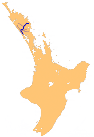
The Wairoa River in Northland New Zealand, sometimes referred to as the Northern Wairoa River, runs for 150 kilometres through the northern part of the North Auckland Peninsula. In the upper reaches, the river is formed from two separate rivers, the Mangakahia River and the Wairua River. The two streams meet to the northeast of Dargaville, becoming the Wairoa. It is the longest river in the Northland Region.
Tauhoa is a rural community in the Auckland Region of New Zealand's North Island.

The Hōteo River is a river of the Auckland Region of New Zealand. It flows southwest from its sources close to the North Auckland Peninsula's east coast before emptying into the southern lobe of the Kaipara Harbour.

The Kaukapakapa River is a river of New Zealand's North Island. It flows west, reaching the southernmost point of the Kaipara Harbour close to the town of Helensville. The small township of Kaukapakapa lies on the banks of the river, some 5 kilometres (3 mi) from its mouth.
The Makarau River is a river of the Auckland Region of New Zealand's North Island. The river rises some 10 kilometres (6 mi) north of Kaukapakapa, flowing west before entering the south of the Kaipara Harbour. The river flows from the confluence of the Tahekeroa River and Haruru Stream.
The Mangawai River is a river of the Northland Region of New Zealand. It flows east into the Wairoa River close to its outflow into the Kaipara Harbour.
The Ōmaumau River is a middle order stream in the Auckland Region of New Zealand's North Island. It flows northwest to reach the Kaipara Harbour 20 kilometres (12 mi) northeast of Helensville. The catchment consists of rural pasture and fragmented native forest.
The Ōpatu River is a tidal creek of the Kaipara Harbour, in the Auckland Region of New Zealand's North Island. It flows west from Te Pahi Stream, before joining another tidal creek of the harbour, the Tauhoa River.

The Oruawharo River is a river on the North Auckland Peninsula of New Zealand. It flows westward into the Kaipara Harbour west of Wellsford. It forms part of the boundary between the Northland region and the Auckland Region.
The Pahi River is a river of the Northland Region of New Zealand's North Island. It flows generally west from its origins southwest of Maungaturoto, and the last few kilometres of its length form an upper silty arm of the Kaipara Harbour. It forms one of the arms of the Arapaoa River, in the northeastern part of the harbour's system.
The Tauhoa River is an estuarial arm of the Kaipara Harbour in the Auckland Region of New Zealand's North Island. As part of the harbour's drowned valley system, it consists of narrow channels flowing south through expanses of mudflat to meet with the main waters of the Kaipara due east of the harbour entrance. The Tauhoa Channel links the entrance with the river mouth.
The Waireia River is a river of the Auckland Region of New Zealand's North Island. Part of the Kaipara Harbour system, it flows north to meet the Oruawharo River 10 kilometres (6 mi) west of Wellsford.
The Whakaki River is located in the Northland Region of New Zealand's North Island. Despite its name, it is better described as a silty arm of the Kaipara Harbour. It flows northwest to reach the Otamatea River.
The Whanaki River is a river of the Auckland Region of New Zealand's North Island. It flows southwest from its origins near Wellsford to reach the Tauhoa River, an arm of the Kaipara Harbour.
Northpower Limited (Northpower) is an electricity distribution company, based in Whangarei, New Zealand.
The Awakino River is a river of the Kaipara District in Northland Region. It flows 38 km (24 mi), generally south from the Awakino Stream, which rises on the Tutāmoe Range, to reach the Wairoa River on the eastern edge of Dargaville. The river is crossed by SH14 and the mothballed Dargaville Branch railway.


