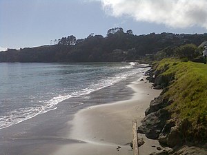
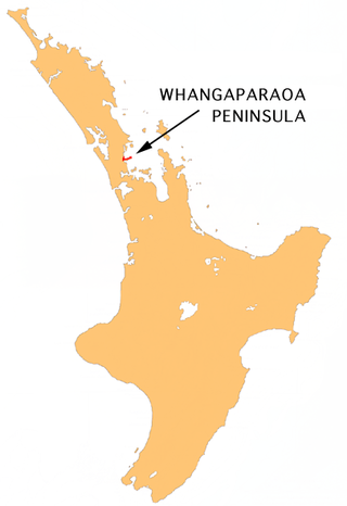
Matakatia is a suburb situated on the Whangaparaoa Peninsula, towards the northern end of Auckland, New Zealand. It is about 43 kilometres (by road) north of the city centre.
Kotanui Island, also called Frenchmans Cap, is a sharp triangular rock rising from the water about 1,000 metres offshore.[3]
History
The Waiau portage between Matakatia and Tindalls Beach allowed the movement of waka in the early 19th century.[4]
A road was developed through the area in 1938[5] and sections were sold the following year.[6]
The area to the north was Tindall's farm in the 1920s[7] and is now the suburb of Tindalls Beach.
Demographics
Tindalls-Matakatia statistical area, which includes Tindalls Beach, covers 2.93km2 (1.13sqmi)[1] and had an estimated population of 2,150 as of June 2024,[2] with a population density of 734 people per km2.
Tindalls-Matakatia had a population of 1,938 in the 2023 New Zealand census, a decrease of 39 people (−2.0%) since the 2018 census, and an increase of 189 people (10.8%) since the 2013 census. There were 951 males, 978 females and 6 people of other genders in 729 dwellings.[10] 2.2% of people identified as LGBTIQ+. The median age was 49.6 years (compared with 38.1 years nationally). There were 294 people (15.2%) aged under 15 years, 270 (13.9%) aged 15 to 29, 900 (46.4%) aged 30 to 64, and 474 (24.5%) aged 65 or older.[9]
People could identify as more than one ethnicity. The results were 89.6% European (Pākehā); 8.8% Māori; 2.6% Pasifika; 7.1% Asian; 1.5% Middle Eastern, Latin American and African New Zealanders (MELAA); and 2.3% other, which includes people giving their ethnicity as "New Zealander". English was spoken by 98.0%, Māori language by 1.2%, Samoan by 0.2%, and other languages by 13.8%. No language could be spoken by 0.9% (e.g. too young to talk). New Zealand Sign Language was known by 0.2%. The percentage of people born overseas was 33.3, compared with 28.8% nationally.
Of those at least 15 years old, 342 (20.8%) people had a bachelor's or higher degree, 873 (53.1%) had a post-high school certificate or diploma, and 321 (19.5%) people exclusively held high school qualifications. The median income was $43,200, compared with $41,500 nationally. 345 people (21.0%) earned over $100,000 compared to 12.1% nationally. The employment status of those at least 15 was that 780 (47.4%) people were employed full-time, 255 (15.5%) were part-time, and 24 (1.5%) were unemployed.[9]
The South Wairarapa District is a district at the south-east tip of the North Island of New Zealand, governed by the South Wairarapa District Council. The district comprises the southernmost part of the Wairarapa, and is part of the Wellington Region.
Horowhenua District is a territorial authority district on the west coast of the North Island of New Zealand, administered by Horowhenua District Council. Located north of Wellington and Kāpiti, it stretches from slightly north of the town of Ōtaki in the south to just south of Himatangi in the north, and from the coast to the top of the Tararua Range. It is in the Manawatū-Whanganui local government region. The name Horowhenua is Māori for landslide.
The Thames-Coromandel District is a territorial authority district in the North Island of New Zealand, covering all the Coromandel Peninsula and extending south to Hikutaia.
Hauraki District is a territorial authority governed by the Hauraki District Council within the Waikato region of New Zealand. The seat of the council is at Paeroa.
Waikato District is a territorial authority of New Zealand, in the northern part of Waikato region, North Island. Waikato District is administered by the Waikato District Council, with headquarters in Ngāruawāhia.
Southland District is a New Zealand territorial authority district that covers most of the southern end of the South Island as well as Stewart Island.
The Whangaparāoa Peninsula is a suburban area about 30–50 km north of Auckland, New Zealand. It had 39,140 residents in June 2024. It stretches from Red Beach, where it connects to Kingsway, Orewa and Silverdale, and extends to Army Bay in the Hauraki Gulf. It is part of the Hibiscus Coast. The area is populated by residents who work on the peninsula, or commute from the area to other parts of the Hibiscus Coast, the North Shore, Rodney district, Auckland CBD and beyond for work. They travel by vehicle, or via the Gulf Harbour ferry at Gulf Harbour Marina, or the Hibiscus Coast Bus Station at Silverdale. There is one main road along its entire length, which is accessible from State Highway 1 via Hibiscus Coast Highway at Silverdale, or from Hibiscus Coast Highway at Orewa via Red Beach. It is popular as a tourist destination for catching a ferry to Tiritiri Matangi Island, and for visiting Shakespear Regional Park. It has one open (Whangaparāoa Golf Club) and one closed golf club (Gulf Harbour Country Club), beaches, sporting and recreation facilities, a library, shops, businesses and public and private primary and secondary schools. The median age of the population is in the 30s-40s.
Central Otago District is local government district in New Zealand. It is administered by the Central Otago District Council, and it is in the Otago region, the top tier of local government in New Zealand. The major towns in the district are Alexandra, Cromwell, Roxburgh, Clyde and Ranfurly. The district covers 9,968 km2 (3,849 sq mi), making it the fourth-largest district in New Zealand by area, and is home to 26,500 people as of June 2024.
Westland District is a territorial authority district on the West Coast of New Zealand's South Island. It is administered by the Westland District Council. The district's population is 9,430.
Grey District is a district in the West Coast Region of New Zealand that covers Greymouth, Runanga, Blackball, Cobden, and settlements along the Grey River. It has a land area of 3,474.31 square kilometres (1,341.44 sq mi). The seat of the Grey District Council, the local government authority that administers the district, is at Greymouth, where 58.4% of the district's population live.
Clutha District is a local government district of southern New Zealand, with its headquarters in the Otago town of Balclutha. Clutha District has a land area of 6,334.47 km2 (2,445.75 sq mi) and an estimated population of 19,300 as of June 2024. Clutha District occupies the majority of the geographical area known as South Otago.
Gulf Harbour is a suburb development some 4 km from the end of the Whangaparāoa Peninsula, and 7 km from Whangaparaoa Town Centre, towards the northern end of Auckland, New Zealand. It has one of the country's largest marinas, and had, until 2023, one of the country's top golf courses, and used to be regarded as a retreat for Auckland's well-off. The site is sometimes also known as Hobbs Bay and was sold in the early seventies by landowners, the Hobbs family, who still retain some of the coastal area including the Hobbs Bay beach.
Taupō District is a territorial authority district in New Zealand. It covers 6,333 km² of land, and a further 610 km² of lake area, including Lake Taupō, New Zealand's largest lake, and Lake Rotoaira. The district stretches from the small town of Mangakino in the northwest to the Tongariro National Park in the south, and east into the Kaingaroa Forest. The district's population is largely located in the two main centres, Taupō and Tūrangi.
Tikipunga is one of the biggest suburbs in Whangārei, New Zealand. It is in the north-east part of the city and has the landmark Whangārei Falls nearby.
Red Beach is a suburb surrounding the beach of the same name on the Hibiscus Coast, Auckland, New Zealand, at the base of the Whangaparaoa Peninsula. The suburb of Silverdale is to the south-west, and Orewa to the north.
Stanmore Bay is a suburb and beach located on the Whangaparaoa Peninsula, in the Auckland Region of New Zealand. The beach is on the northern side of the peninsula.
Ōtorohanga District is a territorial authority in the King Country area and Waikato region of the North Island of New Zealand. It is a mostly rural area, with Ōtorohanga town being by far the biggest urban area, with a population nearing 3,000. The District was called Otorohanga County from 1971 to 1979.
The New Plymouth District is one of the districts of New Zealand within Taranaki. It includes the city of New Plymouth and smaller towns such as Inglewood, Ōakura and Waitara.
Timaru District is a local government district on New Zealand's South Island, administered by the Timaru District Council. It is part of the larger Canterbury Region. Timaru district was formed in 1989 from the amalgamation of Timaru City, Geraldine borough, Temuka borough and Strathallan County.
Waimate District is a territorial authority district located in the Canterbury Region of the South Island of New Zealand. The main town is Waimate, while there are many smaller rural communities dispersed throughout the area. Its boundary to the south is the Waitaki River, to the west Lake Benmore and to the north-east the Pareora River.
This page is based on this Wikipedia article Text is available under the CC BY-SA 4.0 license; additional terms may apply. Images, videos and audio are available under their respective licenses.