Penlink

Last updated

State Highway 19 NZ.svg
State Highway 19
O Mahurangi - Penlink
Penlink
State Highway 19 route
Route information
Maintained by NZ Transport Agency
Length7 km (4.3 mi)
Major junctions
South endState Highway 1 NZ.svg SH 1 at Dairy Flat
North endWhangaparaoa Road at Stanmore Bay
Location
Country New Zealand
Primary
destinations
Whangaparaoa, Stillwater
Highway system

O Mahurangi Penlink [1] (State Highway 19), is a 7-kilometre-long (4.3-mile), [2] two-lane future state highway. [3] Construction began in late 2022 [4] and is expected to conclude in late 2026. [4] Once completed the new state highway will create a more direct and quicker route between the Whangaparaoa Peninsula and central Auckland in New Zealand.

Contents

The road is set to provide a second access route off the Whangaparaoa Peninsula, and is claimed by some[ citation needed ] to be needed to unlock large amounts of commercial land, contribute up to $173 million to GDP during its construction, and create employment estimated at more than 5000 jobs.

Route

The approximately 7-kilometre-long (4.3-mile) Penlink route begins at a new interchange with the Northern Motorway connecting the Whangaparaoa Peninsula with State Highway 1 at Redvale. The interchange includes two southbound city-facing on and off ramps [5] with the ability to construct northbound ramps in the future. [5] The interchange will also include a vehicle connection to East Coast Road, where pedestrians and cyclists can also access the route. [3]

The route will effectively connect the urban area of Hibiscus Coast and Bays, which runs from Waiwera south down the eastern coastline to Campbells Bay.

Along the Penlink route there are three additional interchanges which will help to unlock the western region's potential growth which has been hampered by the traffic pinch point at the Silverdale Motorway Interchange. [5] The new interchanges will tie into Ara Weiti Road and Duck's Creek Road as well as several entirely new roads. This will allow easier access to Stillwater and Karapiro Bay (Weiti Bay) and support future growth and subdivisions in the area. [5]

The Penlink Weiti River Crossing is set to be a 535-metre-long, 45-metre-tall extradosed bridge [6] and will be the first of its kind in New Zealand. [6] The bridge will only have two piers in order to allow vessels to pass between in the centre of the river. [6] On the southern side of the bridge, a pedestrian path and cycleway will allow for access over the river. [3]

At the northern end of the route, the route connects to Whangaparaoa Road, where road users, pedestrians and cyclists will be able to proceed towards the town centre or turn back towards Red Beach. [7]

Future Proposals

History

Initial Proposals

Plans to bridge the Weiti River near Stillwater were first envisaged as early as the 1970s as a way to solve numerous transport issues connecting the Whangaparāoa Peninsular to Auckland City. [11]

Following early property purchases in the 1990s, [12] in 2001, the then-proposed toll-road was first designated in the district plan. [13] Rodney District Council had the project starting in mid-2002 with an expected completion in 2005, having spent $1.53 million [12] on reports and consents. The project was initially expected to cost between $65 million and $69.9 million, [12] which included a provision to widen Whangaparāoa Road.

Prior to the 2008 election, the then Government promised to fund a toll-free joint Regional Fuel Tax (80%) and Council (20%) proposal. [14] The proposal was expected to cost $183 million and begin in 2011. [15] Following a Central Government election defeat, in 2009, the Rodney District Council, who had invested $18 million in land and $5 million in preliminary costs for the project, [11] attempted to appeal to the new Government to continue to fund the two-lane proposal with a possible dynamic lane for rush hour traffic. [11]

Auckland Transport Proposals

With the creation of the Auckland Supercity on 1 November 2010, the project was moved to Auckland Council and its transport entity Auckland Transport who, continued to propose its development.

In 2013, Auckland Transport upgraded the proposal to a four-lane, toll-road. Construction of the new road would start in 2015/2016 and be completed by 2018 at a cost of $243 million. [13] This proposal did not, however, include a provision to widen the existing Whangaparāoa Road. [13] At this point, a two-lane option was no longer considered adequate as it would not be able to support the planned urban growth in the area. [13]

In 2016, a dynamic lane system was installed on an existing two-lane section of Whangaparāoa Road, on a trial basis but then made permanent as a means of reducing congestion on the road in the absence of Penlink and as a cheaper alternative to widening the road as had previously been planned. [16]

By 2018 Penlink was downscaled back to a two-lane road without provision for a dynamic lane, cycle, bus or walking facilities despite protests from locals and politicians. [17] The project was pushed back another two years and now expected to cost $348 million. [17]

NZ Transport Agency Project

In the leadup to the 2020 election, it was announced by the then Government that it would fund the $411 million two-lane road through the New Zealand Upgrade Programme. [18] [19] Expected to start in 2021, the project was intended to be concluded by 2025. [19] Locals expressed concern that the project had been kept as a two-lane highway, likening it to the Harbour Bridge, which had to be widened not long after construction to cope with traffic. [20]

Following the election, the project was then transferred to the NZ Transport Agency, who announced in 2022 that an agreement had been made to construct a two-lane potentially-tolled highway for a substantially higher estimated $830 million, delaying the project's start with completion now not expected until 2026. [21] [2] Alongside the announcement of the project, Auckland Transport confirmed its intention to construct a bus station as part of the project, which would utilise the route to connect users to the CBD. [22]

After many years of delays, changes to the project and cost increases, work finally began in late 2022 with an official sod-turning ceremony. [4]

In October 2023, it was announced that Auckland Transport no longer had the funds to construct the bus station, and as such, it was cancelled. [23]

It was later announced by the Government that the road would be tolled upon completion, contrary to official advice not to. [24] The future (then opposition) Government announced that it would review the decision and consider whether it would be possible to widen the road back to four-lanes. [10]

The road is currently expected to open in 2026. [25]

Related Research Articles

<span class="mw-page-title-main">Georgia State Route 400</span> North-south highway in U.S. state of Georgia

Georgia State Route 400 is a freeway and state highway in the U.S. state of Georgia serving parts of Metro Atlanta. It is concurrent with U.S. Route 19 (US 19) from exit 4 (Interstate 285) until its northern terminus south-southeast of Dahlonega, linking the city of Atlanta to its north-central suburbs and exurbs. SR 400 travels from the Lindbergh neighborhood in the Buckhead district of Atlanta, at Interstate 85 (I-85), to just south-southeast of Dahlonega. Like the Interstate highways, it is a limited-access road, but unlike the interstates, the exit numbers are not mileage-based, they are sequential. Once SR 400 passes exit 18 (SR 369), it changes from a limited-access freeway into an at-grade divided highway with traffic lights, but still with a high speed limit of 65 miles per hour (105 km/h), and ends at the J.B. Jones Intersection at SR 60/SR 115 in Lumpkin County.

<span class="mw-page-title-main">Auckland Harbour Bridge</span> Road bridge in Auckland, New Zealand

The Auckland Harbour Bridge is an eight-lane motorway bridge over the Waitematā Harbour in Auckland, New Zealand. It joins St Marys Bay on the Auckland city side with Northcote on the North Shore side. It is part of State Highway 1 and the Auckland Northern Motorway. The bridge is operated by the NZ Transport Agency (NZTA). It is the second-longest road bridge in New Zealand, and the longest in the North Island.

Whangaparāoa Peninsula Suburban area in Auckland Council, Auckland, New Zealand

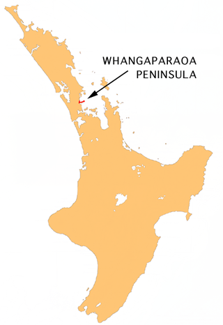
The Whangaparāoa Peninsula is a suburban area about 30–50 km north of Auckland, New Zealand. It had 33,390 residents in 2018. It stretches from Red Beach, where it connects to Kingsway, Orewa and Silverdale, and extends to Army Bay in the Hauraki Gulf. It is part of the Hibiscus Coast. The area is populated by residents who work on the peninsula, or commute from the area to other parts of the Hibiscus Coast, the North Shore, Rodney district, Auckland CBD and beyond for work. They travel by vehicle, or via the Gulf Harbour ferry at Gulf Harbour Marina, or the Hibiscus Coast Bus Station at Silverdale. There is one main road along its entire length, which is accessible from State Highway 1 via Hibiscus Coast Highway at Silverdale, or from Hibiscus Coast Highway at Orewa via Red Beach. It is popular as a tourist destination for catching a ferry to Tiritiri Matangi Island, and for visiting Shakespear Regional Park. It has one open (Whangaparāoa Golf Club) and one closed golf club (Gulf Harbour Country Club), beaches, sporting and recreation facilities, a library, shops, businesses and public and private primary and secondary schools. The median age of the population is in the 30s-40s.

<span class="mw-page-title-main">Māngere Bridge (bridges)</span> Bridge in New Zealand

Māngere Bridge, officially also called the Manukau Harbour Crossing, is a dual motorway bridge over the Manukau Harbour in south-western Auckland, New Zealand, crossing between the suburb also known as Māngere Bridge and the suburb of Onehunga.

<span class="mw-page-title-main">Hibiscus Coast</span> Stretch of the Hauraki Gulf

The Hibiscus Coast is a populated area on a stretch of the Hauraki Gulf coast in New Zealand's Auckland Region. It has a population of 64,660, making it the 10th most populous urban area in New Zealand, and the second most populous in the Auckland Region, behind Auckland itself. As an urban area delineated by Statistics New Zealand, the Hibiscus Coast consists of Hatfields Beach, Orewa, Silverdale and Whangaparāoa Peninsula. The Auckland Council's Hibiscus Coast subdivision of the Hibiscus and Bays includes the neighbouring communities of Waiwera and Stillwater, and Milldale in Rodney, is also described as a part of the Hibiscus Coast.

<span class="mw-page-title-main">State Highway 1 (New Zealand)</span> Road in New Zealand

State Highway 1 is the longest and most significant road in the New Zealand road network, running the length of both main islands. It appears on road maps as SH 1 and on road signs as a white number 1 on a red shield, but it has the official designations SH 1N in the North Island, SH 1S in the South Island.

<span class="mw-page-title-main">Stillwater, Auckland</span> Suburb in Auckland, New Zealand

Stillwater is a village in the northern end of Auckland in the North Island of New Zealand. Situated on the Weiti River immediately south of the Whangaparaoa Peninsula in the Rodney District, it is part of the area known as the Hibiscus Coast. There is also a Stillwater, West Coast in the South Island.

<span class="mw-page-title-main">Auckland Northern Motorway</span> Motorway located in Auckland, New Zealand

The Auckland Northern Motorway in the Auckland Region of New Zealand links Central Auckland and Warkworth in the former Rodney District via the Hibiscus Coast and North Shore. It is part of State Highway 1.

<span class="mw-page-title-main">State Highway 20 (New Zealand)</span> Road in New Zealand

State Highway 20 (SH 20), also known as the Southwestern Motorway, is a New Zealand state highway linking State Highway 1 at Manukau with State Highway 16 in Point Chevalier, via Māngere and Onehunga. Along with its spurs, State Highway 20A and 20B, the state highway serves Auckland Airport, the country's largest, therefore making SH 20 a key arterial route connecting the airport to the wider Auckland region and most of the upper North Island. The route also forms the southern part of the Western Ring Route, a 48 kilometres (30 mi) motorway route bypassing central Auckland.

<span class="mw-page-title-main">Waterview Connection</span> Road in New Zealand

The Waterview Connection is a motorway section through west/central Auckland, New Zealand. It connects State Highway 20 in the south at Mt Roskill to State Highway 16 in the west at Point Chevalier, and is a part of the Western Ring Route.

<span class="mw-page-title-main">State Highway 3 (New Zealand)</span> Road in New Zealand

State Highway 3 (SH 3) is one of New Zealand's eight national state highways. It serves the west coast of the country's North Island and forms a link between State Highway 1 and State Highway 2. Distances are measured from north to south.

<span class="mw-page-title-main">State Highway 2 (New Zealand)</span> Road in New Zealand

State Highway 2 runs north–south through eastern parts of the North Island of New Zealand from the outskirts of Auckland to Wellington. It runs through Tauranga, Gisborne, Napier, Hastings and Masterton. It is the second-longest highway in the North Island, after State Highway 1, which runs the length of both of the country's main islands.

The Waikato Expressway is a dual carriageway section of State Highway 1 in New Zealand's Waikato region. Constructed in stages, it forms part of the link between Auckland and Hamilton. Currently stretching from Auckland to south of Cambridge, the first section of the highway was built in 1993. Throughout its lifetime, it has undergone many upgrades to optimise traffic flow throughout the Waikato region, including various bypasses of many towns in the region, culminating with Hamilton in 2022.

<span class="mw-page-title-main">Second Harbour Crossing, Auckland</span>

The Second Harbour Crossing is the name given to the proposed second transport link across the Waitematā Harbour in Auckland, New Zealand. Planners have also referred to new links across the harbour as the Additional Waitematā Harbour Crossing (AWHC) or the Waitematā Harbour Connections.

<span class="mw-page-title-main">Northwestern Cycleway</span> Cycle route in Auckland, New Zealand

The Northwestern Cycleway is a 12 km mostly off-road cycle route in New Zealand that connects the Auckland CBD with the suburb of Westgate. For most of its length, it runs alongside the Northwestern Motorway.

The Christchurch Northern Motorway is the main northern route into and out of Christchurch, New Zealand. The motorway forms part of State Highway 1 and State Highway 74.

The Western Corridor is a road in Christchurch, New Zealand which connects the suburb of Belfast, New Zealand, in the north to Hornby in the south and connects the Canterbury region to Christchurch Airport. Most of the traffic on the corridor heads to the city, the airport, Belfast or Hornby, while 15% of traffic travels further north or south.

<span class="mw-page-title-main">New Zealand Upgrade Programme</span>

On 29 January 2020, the New Zealand Upgrade Programme was announced by Prime Minister Jacinda Ardern. The programme is a $12 billion infrastructure package to improve roads, rail, hospitals and schools around the country, of which $8 billion has been allocated and the other $4 billion is part of the infrastructure section of the 2020 budget.

<span class="mw-page-title-main">Roads of National Significance</span> Name given by the 5th National Party Government

Roads of National Significance (RoNS) was a name given by the 5th National Party Government, to a programme to speed up road construction in New Zealand between 2009 and 2017.

References

  1. "Penlink update June 2022". createsend.com. Retrieved 21 December 2022.
  2. 1 2 O'Callahan, Heidi (20 June 2022). "Penlink To Start". Greater Auckland. Retrieved 9 March 2024.
  3. 1 2 3 "O Mahurangi Penlink Alignment General Arrangement" (PDF). NZTA. July 2023.
  4. 1 2 3 "O Mahurangi Penlink - December 2022". createsend.com. Retrieved 21 December 2022.
  5. 1 2 3 4 5 6 "Penlink Implementation Business Case" (PDF). NZTA. Retrieved 9 March 2024.
  6. 1 2 3 "Weiti River Crossing" (PDF). NZTA.
  7. "Penlink: Whangaparaoa Road Connection (updated)" (PDF). NZTA.
  8. "Whangaparaoa Bus Interchange". Auckland Transport. Retrieved 9 March 2024.
  9. 1 2 3 "Notice of Requirement 12: General Arrangement" (PDF). Auckland Council.
  10. 1 2 "Nats to review Michael Wood's decision to toll Penlink road and look to extend it to four lanes". NZ Herald. 9 March 2024. Retrieved 9 March 2024.
  11. 1 2 3 "Penlink: Rodney's Flagship Ready-to-Go Infrastructure Project" (PDF). Rodney District Council.
  12. 1 2 3 "Plea for action on Weiti River crossing". NZ Herald. 9 March 2024. Retrieved 9 March 2024.
  13. 1 2 3 4 "Penlink Business Case" (PDF). Auckland Transport. 20 February 2015. Retrieved 9 March 2024.
  14. Dearnaley, Mathew (7 October 2008). "Regional fuel tax to help fund Penlink". The New Zealand Herald . Retrieved 2 November 2011.
  15. "Reflections on Auckland Planning". joelcayford.blogspot.com. Retrieved 9 March 2024.
  16. "Dynamic Lanes: latest solution for Whangaparaoa Road Gridlock". Local Matters. 25 May 2016. Retrieved 9 March 2024.
  17. 1 2 Newson, Rhonwyn. "Penlink downscaled and pushed back to end of the decade". stuff.co.nz. Retrieved 6 August 2018.
  18. Orsman, Bernard (30 January 2020). "Jacinda Ardern kicks off the election campaign pledging billions of dollars for new roads". The New Zealand Herald . Retrieved 3 May 2022.
  19. 1 2 L, Matt (29 January 2020). "The NZ Upgrade transport package". Greater Auckland. Retrieved 9 March 2024.
  20. "Government told not to repeat Harbour Bridge blunder". NZ Herald. 9 March 2024. Retrieved 9 March 2024.
  21. "Momentum builds as Penlink partners put pen to paper | Waka Kotahi NZ Transport Agency". www.nzta.govt.nz. Retrieved 9 March 2024.
  22. "AT wants a new bus terminal in Whangaparaoa". Hibiscus Coast App. Retrieved 9 March 2024.
  23. "Penlink bus station disappears down budget hole". Hibiscus Matters. 3 October 2023. Retrieved 9 March 2024.
  24. "Toll road decision under fire: Wood ignored official advice on charging motorists". NZ Herald. 9 March 2024. Retrieved 9 March 2024.
  25. "Penlink: Frequently asked questions". NZTA. Retrieved 3 May 2022.