Last updated • 14 min readFrom Wikipedia, The Free Encyclopedia
Road tunnel in Christchurch, New Zealand
This article's lead section contains information that is not included elsewhere in the article. If the information is appropriate for the lead of the article, this information should also be included in the body of the article.(December 2020) ( Learn how and when to remove this message )
While the tunnel itself was not damaged due to the February 2011 Christchurch earthquake, the Heathcote tunnel canopy was destroyed. The nearby Tunnel Control Building — a Category I heritage building – suffered significant damage and was closed, before finally being demolished in 2013. Construction of a new control building was completed in 2014.[2][full citation needed]
History
Early settler efforts
This section may be unbalanced toward certain viewpoints. Please improve the article by adding information on neglected viewpoints, or discuss the issue on the talk page.(December 2020)
When the first Europeans settled in Canterbury in the 1850s[disputed–discuss] with no deepwater ports available other than on Banks Peninsula, they had to transport their produce from the plains to Heathcote, near Sumner.[dubious–discuss][citation needed] From there it was taken by longboat and lighter around Lyttelton Heads to ships waiting in Lyttelton harbour.[dubious–discuss][citation needed] The only other route[citation needed] was via the Bridle Path that was constructed in 1850 and was used by the early European settlers as a route from the port to new settlements on the northern side of the Port Hills.[citation needed] Although very steep, it was the only means of traversing the hills.[citation needed] In 1851 a Select Committee enquired into the best means of access to the sea.[dubious–discuss][citation needed] Among the options a road tunnel was considered and rejected, one reason being that horses would catch cold coming from the hot plains into a cold tunnel.[3] Instead a road via Evans Pass[clarification needed] which is near the eastern end of the Port Hills, was selected[dubious–discuss] to connect Sumner and Lyttelton, and was completed in 1857 at a cost of £30,000.[4]
The Evan's Pass soon proved unsatisfactory[citation needed] as the transportation needs of the province increased, which lead to the construction of the rail tunnel which linked Lyttelton and Christchurch by 1867.[5] At this time, Canterbury's total population was only 10,000.[citation needed]
Two more road links, steeper and longer than the first[clarification needed], have been built; one which reaches Lyttelton via Dyers Pass by way of the head Lyttelton harbour at Governor's Bay, and an even longer one through Gebbie's Pass. In spite of its length, valuable heavy transport had to sometimes use Gebbie's Pass as frosts in winter could made the other two roads unsafe.[6][failed verification]
Alternative options
The introduction of motor vehicles to New Zealand highlighted the need for a better road connection. Two alternatives, a road tunnel or canal, became the subject of considerable argument. In 1919 the Australian firm of Smith, Timms and Kidman offered to construct a road tunnel in three years for £700,000 or about £624,000 if the proposed tramline was eliminated, but the scheme lapsed.[3][7]
By 1920 the Christchurch-Lyttelton Tunnel Road League (which by 1922 had become the Port and City League) had been established to push for the building of a tunnel.[8]
There was also a Port Christchurch League which advocated for a port at the estuary of the Heathcote and Avon rivers. Sir Joseph Ward, Prime Minister and Minister of Railways in 1929, arranged a Government grant of £1,000 to the Port and City League, to set up a commission to investigate the matter provided; a similar sum was raised by the League.[3] This was regarded by the League as a significant gesture of official backing.[9] The resulting "Direct Access to the Sea Commission" concluded in July 1930 that they could not recommend the adoption of the proposals for either a road tunnel or a port at Christchurch as this would cause "serious hardship to traders and the farming community".[10]
The Canterbury Chamber of Commerce campaigned through the 1930s and 1940s for a road tunnel but without success until 1944, when Bill MacGibbon (deputy chairman of the Lyttelton Harbour Board and prominent in the movement to build a tunnel) was able to convince the New Zealand government to allow the Ministry of Works to prepare plans.[11]
In April 1937, a conference convened by Canterbury Chamber of Commerce with the support of the Prime Minister Michael Savage, which had 28 public bodies in attendance, made a recommendation for the construction of a road tunnel. The advent of the Second World War, however, put a stop to all but essential construction projects. In 1943, a conference attended by 19 public bodies resulted in the establishment of a Tunnel Road Promotion Committee.[12] In 1944 the Minister of Works, Bob Semple, met deputations from both the Tunnel Road Promotion Committee and the Canal League. He considered that the canal scheme, then estimated to cost £5,000,000,[3] had no hope of success, whereas he was very favourably impressed with the road tunnel scheme, then estimated to cost £750,000.[13]
Progress was still slow though in June 1949 a Gazette notice was issued authorising the construction of a motorway as a tunnel road. This was followed in 1952 by a survey defining the limits of the land required.
Establishment of the Road Tunnel Authority
The years following the end of the Second World War saw no further progress until in 1953 Sidney Holland, the member of parliament for Fendalton in Christchurch and also more critically prime minister, sponsored the Christchurch-Lyttelton Road Tunnel Bill, which established a seven-man authority to construct and control a road tunnel with authority to raise the raise loan, construct the tunnel and pay back the loan by levying tolls.[11] The bill was subsequently passed into law in October 1956 with the Government guarantying the repayment of any loans raised by the Road Tunnel Authority.[3]
By 1956 the MOW estimated the project would cost £2.515 million.[14] The Ministry of Works and Development (MOW) were appointed as consulting engineers to the Road Tunnel Authority; with the assistance of the Civil Engineering Department of Canterbury University they began the design of the road tunnel. A drilling programme was carried out in the proposed portal areas to locate bedrock. Various options were considered with an early tunnel design having a width of 37ft (11m), consisting of a 24ft (7.3m) wide roadway with a 5ft 6 in (1.68 m) wide cycle track on either side.[15] As the cycle tracks were estimated to raise the cost by £500,000 they were dropped. The final design called for a 24ft (7.3m) wide roadway with 2ft (0.61m) wide kerbs on either side for use by maintenance personnel and to assist in keeping motor vehicles from scrapping the tunnel walls.[3][15]
Following discussions about the route and the width of the tunnel which allowed finalisation of the estimated cost the newly created Road Tunnel Authority under the chairmanship of Bill MacGibbon (ca. 1891 – 1962) applied to the Local Authorities Loans Board in 1959 for approval to raise a loan, only for it to be turned down. The reason given was that if the planned new harbour facilities at Lyttelton were not available before the tunnel opened then there would be insufficient freight moving through the tunnel in its early years to generate the toll revenue need to service the loan. After the sending of a deputation to the Prime Minister (Walter Nash) and the Minister of Finance (Arnold Nordmeyer) and then a written assurance from the Road Tunnel Authority that the tunnel would not be completed prior to the completion of the harbour upgrades, approval was given in March 1960 for the raising of a loan of £3,250,000. So far £2,652,330 had been raised, most of it in parcels at 4.875% and 5%.[3]
Call for tenders
With the design and specifications completed by August 1960 the MOW called for tenders to undertake the project, which as a result of their detailed design they estimated would cost £3,500,000.[11] The contract called for the work to be priced on linear footage basis, which put the onus on the contract bidders to determine the likely ground conditions, which would impact on how long it would take to dig the tunnel. Fortunately, the records from the construction of the rail tunnel between 1861 and 1867 were still available.[11]
Tenders were received in January 1961 for building the tunnel from seven companies, the prices varying from £1,770,431 to £3,774,117, with all but two being a combination of a New Zealand contractor and an international contractor.[11][3] As the Road Tunnel Authority had reserved the right to tile the tunnel surfaces if funds permitted, it decided to exercise this option and awarded a £1,947,748 contract which included tiling of the tunnel on 28 January 1961[3] to the lowest bidder, a 60/40 joint venture of New Zealand-owned Fletcher Construction and Kaiser Engineers and Constructors of the United States of America.[11][3]
In addition, a motorway was to be built from Ferry Road to the Heathcote Underpass near the Heathcote portal, a distance of some 2+1⁄2 miles (5km). This required the construction of bridges over the Ōpāwaho / Heathcote River and the Lyttelton railway line, an interchange and underpass system at the bottom of Horotane Valley. This work cost approximately £530,000 and was paid for by the National Roads Board.[3]
Construction
The contract specified the project had to be completed within three years, irrespective of whether the tunnel was fully lined with tiles or not. With it expected to take six months to import the equipment and material and establish on site, then allowing nine months at the end of the schedule to tile the tunnel, Fletcher-Kaiser's project manager Jack (J.G.) Smith estimated they only had 21 months to dig and concrete the tunnel. Whereas the law had previously required that when digging tunnels that all workings were opened from each end and that no internal combustion engines could be used within the tunnel, the 1960 Quarries Act allowed a diesel engine fitted with scrubbers to be used and had no requirement for the workings to be open end to end. Having identified that it was more advantageous than digging from Lyttelton, Fletchers-Kaiser dug the tunnel from the Heathcote end. Fletcher-Kaiser employed Burnett Motors of Ashburton and Isaac Construction of Christchurch to excavate the 1+1⁄4-mile-long (2km) approach road to the tunnel from the nearest road at the bottom of the Heathcote valley.
Work on digging the tunnel had been underway for a month with 180ft (55m) excavated by the time the ceremonial 'firing of the first shot' to officially signal work on the tunnel took place on 9 September 1961.[11]
Within a short time the tunnel was progressing at a rate of 23.2ft (7.1m) per day, working three shifts, six days a week. The tunnellers received a basic hourly wage of 7s −2d per hour. Despite the use of water exhaust scrubbers on the diesel-powered excavation equipment it was still found necessary improve the ventilation by locating near the rock face two 200hp 5ft 6 in diameter fans capable of exhausting 100,000 cubic feet per hour via a flexible 6ft (1.8m) diameter flexible plastic pipe to the portal. Although by the time the tunnel having reached the 60% point it was found that the clearing of flumes and smoke was becoming a problem. Despite the use of several auxiliary fans it was found necessary to drive a small 7ft (2.1m) by 4ft (1.2m) ventilation tunnel for the Lyttelton end to connect with the main heading. Once the connection had been made at the 1,160ft (350m) from the Heathcote end one of the main ventilation fans was moved to the Lyttelton end. Despite the cost of driving the ventilation tunnel, it was found that it speeded up the driving of the main tunnel by allowing a more effective cutting, reducing the amount of explosives being used and more quickly clearing the smoke and flumes after blasting.[11]
It was found necessary to support with steel framework only 8% of the tunnel due to unstable ground conditions. In all other areas, either rock bolts or a combination of steel mesh and sprayed concrete were used to restrain potential loose rock. A total of 1,400 rock bolts were used.
Despite being delayed by wet weather at the start of the work the excavation of the tunnel was completed on 18 August 1962, within both the time and budget.[11] Work moved to concreting the interior of the tunnel. Concrete for the tunnel was supplied from a temporary concrete mixing plant established by Certified Concrete on a rail siding 2mi (3.22km) from the tunnel portal. A minimum of four agitator trucks conveyed concrete from the plant to the tunnel. Over 45,000 cubic yards (34,405 cubic metres) of concrete were placed within the tunnel with a further 4,500 cubic yards (3,440 cubic metres) placed outside.[11] After the tunnel's concrete walls had been sandblasted they were lined with 306,000 sq ft of tiles imported from overseas using a newly invented epoxy glue made by Fletcher industries using technology sourced from the Australian company of A C Horn. Ventilation buildings were constructed at both ends of the tunnel in each of which were located one fresh-air and one exhaust fan, both 12ft (3.7m) in diameter.
The final price awarded to Fletchers and Kaiser including all variations was £2,112,542, 8.5% above the original contract award though it took four years before the Road Tunnel Authority paid it all.[11]
By the time the purchase of property, construction of the Lyttelton Tunnel Control Building, the consultant's fee of the Ministry of Works and loan interest during construction were included the total cost (excluding the motorway) was £2.7 million.[3][16]
Opening
On the first night that cars were allowed through the queue stretched from the tunnel, down Ferry Rd and into Barbadoes Street as far back as the Cathedral of the Blessed Sacrament in Christchurch.[17]
When the tunnel officially opened on 27 February 1964 by Governor-General Sir Bernard Fergusson[18] it was hailed by the local community as "the new gateway for the Port to the Plains" and a significant development in the history of the region.[2]
A 20-cent toll levied to use the tunnel was abolished by the Christchurch-Lyttelton Road Tunnel Authority Dissolution Act 1978, which became effective on 1 April 1979.[19]
Service history
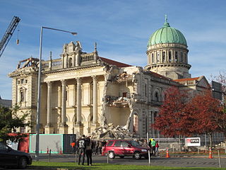
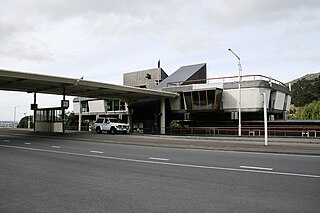
The original Lyttelton Road Tunnel Administration Building, designed by Christchurch architect Peter Beaven, was a Category I listed heritage building and one of the youngest buildings recognised by the trust.[20] Following its demolition as a result of damage sustained in the February 2011 Christchurch earthquake, a new control building, constructed to 180% of the Building Code to withstand future earthquakes, was completed in 2014 at a cost of $1.5 million.[2]
As of 2010[update], the tunnel has an AADT (average daily traffic volume) of 10,755vehicles/day, of which 12.3% are heavy goods vehicles.[21]
Incidents
In August 2008, the tunnel was closed to northbound traffic due a landslide in bad weather conditions.[22] The tunnel was also closed temporarily following the 2010 Canterbury earthquake and subsequent aftershocks to allow for structural integrity inspections to take place. Service generally resumed within 20 minutes of each aftershock.[23]
The tunnel was again closed following the February 2011 Christchurch earthquake.[24] The tunnel canopy was severely damaged by rockfall and was demolished within days.[25] Following initial engineers' inspection the tunnel reopened to emergency vehicles later the same day.[26] Access was limited to Lyttelton residents only from 26 February before fully reopening.[27] The Tunnel Control Building was also badly damaged and deemed unfit for occupation.[28]
It was subsequently demolished in early 2013, and a new purpose-built Lyttelton Tunnel Control Building for managing the tunnel's operation and maintenance was constructed and completed in June 2014. A community celebration was held on 31 August 2014 to jointly open the new Lyttelton Tunnel Control Building and commemorate the tunnel's 50th anniversary. To manage the operation and maintenance of the tunnel the Lyttelton Road Tunnel Administration building designed by Christchurch architect Peter Beaven was constructed at the Heathcote end of the tunnel. The distinctive building was given a New Zealand Historic Places Trust Category 1 listing in 2008.
Operation
Cyclists are not allowed to use the tunnel, although for many years they were allowed to pass through on one day a year. For example, the 2001 tunnel ride was held in conjunction with the 3rd NZ Cycling Conference.[29] However, since 2007 Christchurch buses have been equipped with bicycle carriers to allow cyclists access between Heathcote and Lyttelton.[30]
Images
Lyttelton road tunnel
Southern (Lyttelton) portal of the Lyttelton road tunnel under construction in 1964
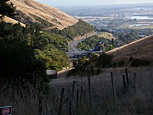
Northern (Heathcote) portal of the Lyttelton road tunnel in 2010
Southern (Lyttelton) portal of the Lyttelton road tunnel in 2010
Inside Northern (Heathcote) portal of the Lyttelton road tunnel in 2010
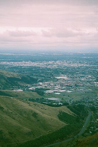
Northern portal from the Bridle Path, May 2010
Related Research Articles
Sumner is a coastal seaside suburb of Christchurch, New Zealand and was surveyed and named in 1849 in honour of John Bird Sumner, the then newly appointed Archbishop of Canterbury and president of the Canterbury Association. Originally a separate borough, it was amalgamated with the city of Christchurch as communications improved and the economies of scale made small town boroughs uneconomic to operate.
Ferrymead is a suburb south-east of Christchurch, New Zealand. It is the main thoroughfare for reaching the eastern sea suburbs such as Sumner, as well as home to a number of cliff-top residences and businesses along the estuary front. After the 2011 Canterbury earthquake, a number of prominent Christchurch businesses relocated to the Ferrymead area, making it into a secondary business hub.
The Ferrymead Railway is a New Zealand heritage railway built upon the track formation of New Zealand's first public railway, from Ferrymead to Christchurch, which opened on 1 December 1863. On the opening of the line to Lyttelton on 9 December 1867, the Ferrymead Railway became the Ferrymead Branch and was closed shortly thereafter. In 1964, rail enthusiasts began relaying track on the historic formation and the new 3 ft 6 in narrow gauge. Ferrymead Railway officially reopened in 1977. It now operates steam, diesel and electric trains regularly and is recognised as one of the most significant rail preservation sites in New Zealand.
Christchurch is the largest city in the South Island and the second-largest city by urban area population in New Zealand. Christchurch has a population of 396,200 and is located in the Canterbury Region, near the centre of the east coast of the South Island, east of the Canterbury Plains. It is located near the southern end of Pegasus Bay, and is bounded to the east by the Pacific Ocean and to the south by the ancient volcanic complex of the Banks Peninsula. The Avon River (Ōtākoro) winds through the centre of the city, with a large urban park along its banks. With the exception of the Port Hills, it is a relatively flat city, on an average around 20 m (66 ft) above sea level. Christchurch has a reputation for being an English city, with its architectural identity and nickname the 'Garden City' due to similarities with garden cities in England. Christchurch has a temperate oceanic climate with regular moderate rainfall.
Lyttelton is a port town on the north shore of Lyttelton Harbour / Whakaraupō, at the northwestern end of Banks Peninsula and close to Christchurch, on the eastern coast of the South Island of New Zealand.
Opawa is an inner residential suburb of Christchurch, New Zealand. It is located approximately 3.5 kilometres south-east of the city centre. Prior to European settlement, much of the area consisted of marshlands and mixed-use vegetation. By the 1860s, the area was sparsely populated by settlers and became an agricultural dairying locality, with many of the early settlers of English descent. It developed little during its early years in becoming a residential suburb. As Woolston emerged as an industrial hub nearby, Opawa was heavily urbanised, transforming it into an upscale residential area with a population largely comprised of factory workers and businesspeople. Opawa also contributed in the development of Christchurch with its former brickmaking and clay industries.
Woolston is an industrial and residential suburb of Christchurch in the South Island of New Zealand. It is situated 3 kilometres southeast of the city centre, close to major arterial routes including State Highways 74 and 76 to Banks Peninsula. The Heathcote River flows through the suburb.
The Bridle Path is a steep shared-use track that traverses the northern rim of the Lyttelton volcano connecting the port of Lyttelton with the city of Christchurch in the South Island of New Zealand. It is a popular walking and mountain biking route. The track ascends from the port itself to a height of 333 metres (1,093 ft) before descending again via Heathcote Valley to Christchurch. At the summit, next to the Summit Road, is a stone shelter with covered seats that is a 1940 New Zealand centennial memorial to the Pioneer Women of Canterbury. There are also seven commemorative stone seats placed along the Bridle Path; most of these were built for the 1950 Canterbury centenary celebrations.
Mount Cavendish is located in the Port Hills, with views over Christchurch, New Zealand and Lyttelton. It is part of the crater wall of the extinct volcano that formed Lyttelton Harbour. The Mount Cavendish Reserve displays some of the best examples of lava flow to be seen on the Port Hills.
The Sign of the Takahe is a neo-Gothic style historic building in Christchurch, New Zealand. It is currently leased from Christchurch City Council and run as a pop in cafe, bar, and now focuses on wedding & functions.
The Christchurch Town Hall, since 2007 formally known as the Christchurch Town Hall of the Performing Arts, opened in 1972, is Christchurch, New Zealand's premier performing arts centre. It is located in the central city on the banks of the Avon River overlooking Victoria Square, opposite the former location of the demolished Christchurch Convention Centre. Due to significant damage sustained during the February 2011 Christchurch earthquake, it was closed until 2019. Council staff initially recommended demolition of all but the main auditorium, but at a meeting in November 2012, councillors voted to rebuild the entire hall. In 2020, the town hall was registered as a Category I heritage building.
Public transport in Christchurch, New Zealand, consists of bus services operated by two bus companies supported by a ferry, all jointly marketed as Metro, a division of Environment Canterbury (ECan).
The Lyttelton Rail Tunnel, initially called the Moorhouse Tunnel, links the city of Christchurch with the port of Lyttelton in the Canterbury region of New Zealand's South Island. It is the country's oldest operational rail tunnel, and is on the Lyttelton Line, one of the first railways built by Canterbury Provincial Railways.
Lyttelton Line is a name sometimes used to refer to the section of the Main South Line in New Zealand's South Island between Lyttelton and Christchurch, and can also be used to refer to the operations on this section. As it has always been part of the Main South Line, this name has never been officially used to refer to the track itself.
A major earthquake occurred in Christchurch on Tuesday 22 February 2011 at 12:51 p.m. local time. The Mw6.2 earthquake struck the Canterbury region in the South Island, centred 6.7 kilometres (4.2 mi) south-east of the central business district. It caused widespread damage across Christchurch, killing 185 people in New Zealand's fifth-deadliest disaster.
Warner's Hotel in 50 Cathedral Square, Christchurch is the site of a hotel established in 1863. The original building, extended on numerous occasions, burned down in 1900. A new building was built in 1901. Again, it underwent numerous alterations. A fourth storey was added in 1910 and the northern end of the building was demolished in 1917 and a theatre built in its place to create a noise buffer to the printing presses of the adjoining Lyttelton Times Building. The theatre was demolished in 1996 and patrons enjoyed a beer garden. In 2010, a high-rise Novotel hotel opened on the site of the beer garden and in the process, the historical and symmetrical 1901 façade was recreated.
The June 2011 Christchurch earthquake was a shallow magnitude 6.0 Mw earthquake that occurred on 13 June 2011 at 14:20 NZST. It was centred at a depth of 7 km (4.3 mi), about 5 km (3 mi) south-east of Christchurch, which had previously been devastated by a magnitude 6.2 MW earthquake in February 2011. The June quake was preceded by a magnitude 5.9 ML tremor that struck the region at a slightly deeper 8.9 km (5.5 mi). The United States Geological Survey reported a magnitude of 6.0 Mw and a depth of 9 km (5.6 mi).
The Lyttelton Road Tunnel Administration Building was built in the mid-1960s as an operational building for the Lyttelton road tunnel in Christchurch, New Zealand. The building was designed by architect Peter Beaven and is seen as significant in the development of New Zealand architecture.
Christchurch is a major city in the Canterbury Region, and is the largest city in the South Island of New Zealand. Established as a colonial outpost of the British Empire in 1850, it is today the second largest city in New Zealand, after Auckland.
1 2 3 4 5 6 7 8 9 10 11 Smith, Jack (2014). No Job Too Hard. A History of Fletcher Construction Volume II: 1940 – 1965. Wellington: Steele Roberts. pp.499–504, 507–511. ISBN978-1-927242-36-0.
↑ "Tunnel Road", Press, 25 August 1943, retrieved 5 April 2018
This page is based on this Wikipedia article Text is available under the CC BY-SA 4.0 license; additional terms may apply. Images, videos and audio are available under their respective licenses.