
Lyttelton is a port town on the north shore of Lyttelton Harbour / Whakaraupō, at the northwestern end of Banks Peninsula and close to Christchurch, on the eastern coast of the South Island of New Zealand.

Cathedral Square, locally known simply as the Square, is the geographical centre and heart of Christchurch, New Zealand, where the city's Anglican cathedral, ChristChurch Cathedral is located. The square stands at the theoretical crossing of the city's two main orthogonal streets, Colombo Street and Worcester Street, though in practice both have been either blocked off or detoured around the square itself. The square was badly damaged in the February 2011 Christchurch earthquake.

The Christchurch Town Hall, since 2007 formally known as the Christchurch Town Hall of the Performing Arts, opened in 1972, is Christchurch, New Zealand's premier performing arts centre. It is located in the central city on the banks of the Avon River overlooking Victoria Square, opposite the former location of the demolished Christchurch Convention Centre. Due to significant damage sustained during the February 2011 Christchurch earthquake, it was closed until 2019. Council staff initially recommended demolition of all but the main auditorium, but at a meeting in November 2012, councillors voted to rebuild the entire hall. In 2020, the town hall was registered as a Category I heritage building.

The Lyttelton road tunnel runs through the Port Hills to connect the New Zealand city of Christchurch and its seaport, Lyttelton. It opened in on 27 February 1964 and carries just over 10,000 vehicles per day as part of State Highway 74.

The Lyttelton Rail Tunnel, initially called the Moorhouse Tunnel, links the city of Christchurch with the port of Lyttelton in the Canterbury region of New Zealand's South Island. It is the country's oldest operational rail tunnel, and is on the Lyttelton Line, one of the first railways built by Canterbury Provincial Railways.

Lyttelton Line is a name sometimes used to refer to the section of the Main South Line in New Zealand's South Island between Lyttelton and Christchurch, and can also be used to refer to the operations on this section. As it has always been part of the Main South Line, this name has never been officially used to refer to the track itself.

Christchurch railway station is in the Canterbury region of New Zealand's South Island. It is on the Main North Line at Addington junction, and is the only remaining passenger railway station in the city: suburban passenger trains were cancelled due to lack of demand in the 1970s. It is the terminus of the South Island's two remaining long-distance passenger trains, the Coastal Pacific to Picton and the TranzAlpine to Greymouth.

Lyttelton railway station is the northern terminus of the Main South Line, a main trunk railway line from Lyttelton to Invercargill in the South Island of New Zealand. There have been three stations built at Lyttelton, with the most recent of these still being used for railway purposes.

John Anderson was the second Mayor of Christchurch in New Zealand 1868–1869, and a successful businessman. He had a close connection with three buildings that have later received Category I heritage registrations by Heritage New Zealand. Two of these buildings were demolished following the February 2011 Christchurch earthquake.

Edward Richardson was a New Zealand civil and mechanical engineer, and Member of Parliament. Born in England, he emigrated to Australia and continued there as a railway engineer. Having become a partner in a contracting firm, a large project caused him to move to Christchurch in New Zealand, in which country he lived for the rest of his life.

The Lyttelton Timeball Station is a heritage-registered time ball station and prominent local landmark in Lyttelton, New Zealand. The original station was significantly damaged by a series of earthquakes and aftershocks in 2010 and 2011, and finally collapsed on 13 June 2011 after a magnitude 6.4 aftershock. The tower was subsequently reconstructed, reopening in November 2018.

The Lyttelton Times was the first newspaper in Canterbury, New Zealand, publishing the first edition in January 1851. It was established by the Canterbury Association as part of its planned settlement of Canterbury and developed into a liberal, at the time sometimes seen as radical, newspaper. A successor paper, The Star, is published as a free bi-weekly newspaper.

The Lyttelton Times Building, last known as Base Backpackers, in 56 Cathedral Square, Christchurch Central City, was the last headquarters of the Lyttelton Times before its demise in 1935 as the then-oldest newspaper in New Zealand. The building in Chicago School architectural style was registered with New Zealand Historic Places Trust as a Category I heritage item, with the registration number 7216. The building's last use was as a backpackers' hostel and a restaurant. It was demolished following the February 2011 Christchurch earthquake.
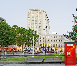
Warner's Hotel in 50 Cathedral Square, Christchurch is the site of a hotel established in 1863. The original building, extended on numerous occasions, burned down in 1900. A new building was built in 1901. Again, it underwent numerous alterations. A fourth storey was added in 1910 and the northern end of the building was demolished in 1917 and a theatre built in its place to create a noise buffer to the printing presses of the adjoining Lyttelton Times Building. The theatre was demolished in 1996 and patrons enjoyed a beer garden. In 2010, a high-rise Novotel hotel opened on the site of the beer garden and in the process, the historical and symmetrical 1901 façade was recreated.

The Guthrey Centre at 126 Cashel Street, Christchurch Central City, originally the offices of Andersons Foundry and later 'Andersons Ltd, was a Category I heritage building registered by the New Zealand Historic Places Trust. The building was demolished following severe damage from the February 2011 Christchurch earthquake.
Peter Jamieson Beaven was a New Zealand architect based in Christchurch, who lived for his last few months in Blenheim. He was a co-founder of New Zealand's first heritage lobby group, the Civic Trust.

St Saviour's at Holy Trinity is an Anglican church in Lyttelton, Christchurch, New Zealand. St Saviour's Chapel was relocated from West Lyttelton to Christchurch's Cathedral Grammar School in the 1970s. Following the earthquakes and the demolition of Holy Trinity Church, Lyttelton, St Saviour's was returned to Lyttelton to the site of Holy Trinity in 2013.
Samuel Charles Farr was a 19th-century builder and architect in Christchurch, New Zealand. He intended to emigrate from England to Auckland, but significant shipping problems saw him end up in Akaroa in 1850 instead. From 1862, he lived in Christchurch. Farr has a number of firsts against his name: the first marriage in Canterbury, he designed Akaroa's first church, designed New Zealand's first iron verandahs, and he started Sunday schools in Canterbury. As a leading member of the Acclimatisation Society, he stocked almost every lake and river in Canterbury with fish and was instrumental in introducing the bumblebee to New Zealand. His most notable building was Cranmer Court, the former Normal School, in the Christchurch Central City; this building was demolished following the February 2011 Christchurch earthquake.

The Lyttelton Borough Council Chambers was the headoffice of the Lyttelton Borough Council from 1887 until the late 20th century, when the borough council moved to a number of other buildings. Civic use of the building stopped in 1999, when the building was sold for business and residential use. Registered by the New Zealand Historic Places Trust in 2003, the building was demolished in June 2011 following the 2011 Christchurch earthquake.

