East Lake (New Zealand)

Last updated
The proposed location of East Lake viewed from its southern end; there was dense housing here until the earthquakes East Lake 138.JPG
The proposed location of East Lake viewed from its southern end; there was dense housing here until the earthquakes

East Lake is an open water course under consideration in Christchurch, New Zealand. The facility, located within the residential red zone adjacent to the Avon River, would be suitable for international rowing regattas. The facility is estimated at NZ$160m to construct.

Contents

History

Earlier rowing lake proposals

There have been proposals for an international rowing facility for Christchurch since the early 2000s. The first proposal is known under the name Lake Isaac, an artificial lake on land known as McLeans Island next to the Waimakariri River owned by Diana Isaac. The proposal died when it was opposed by neighbouring Christchurch International Airport, with executives fearing that attracting more water foul to the area would increase the risk of bird strike for planes landing or starting. [1] [2] The plans for Lake Isaac were given to the International Rowing Federation (FISA) and from them were passed on to the organisers of the 2012 Summer Olympics, and were the blueprint for Dorney Lake. [2]

Later in the 2000s, a proposal was developed to use the Henderson Basin in Halswell for a rowing course. [1] Before the plans could be much further, the 2010 and 2011 earthquakes happened. [3] [4]

East Lake proposal

As a result of the earthquakes, large areas of land along the Avon River was deemed as unsuitable for housing, the residential red zone was gazetted starting in June 2011, and the land purchased by the Crown for NZ$1.5b. [3] [4] It was reported in 2012 that the idea of using the red zone had found the support of the Earthquake Recovery Minister, Gerry Brownlee. The minister has two relatives who have represented New Zealand in rowing; his uncle Mark Brownlee represented New Zealand at the 1964 and 1968 Olympics, [5] and his cousin Scott Brownlee represented New Zealand at the 1992, 1996, and 2000 Olympics. [6] [3] In December 2013, Brownlee first publicly supported a water course for rowing, swimming, and triathlon, while at the same time acting as a large stormwater holding basin that could reduce flooding (the earthquakes had resulted in land to subside). Earlier in the year, Brownlee had consulted with those who were responsible for constructing Lake Dorney. [7]

The government agency responsible for the red zone, the Canterbury Earthquake Recovery Authority (CERA), never engaged with the public on what could eventually happen with the land. In this information vacuum, a community group—Eastern Vision—formed itself to work with the community on their aspirations; Eastern Vision was led by Peter Beck and Evan Smith. Twenty-seven key projects were considered for east Christchurch, and the proposal for East Lake found wide support. Two lake proposals were considered, with lengths of 1.25 kilometres (0.78 mi) and 2.25 kilometres (1.40 mi) in length, and Beck reported that over 80% of respondents agreed or strongly agreed with the longer lake. [8] The East Christchurch Water Sports Community Trust formed itself in 2014 to progress the proposal and has since renamed itself East Lake Trust. [9] It is proposed to also provide other aquatic facilities, like boarding assisted by a cable ("cable boarding"), and an artificial white water rafting facility. [9]

When CERA ceased to exist in April 2016, some of its functions were taken over by Regenerate Christchurch, a joint agency of the Crown and Christchurch City Council responsible for developing and overseeing regeneration plans. [10] Part of the brief that Regenerate Christchurch was given is to investigate the feasibility of East Lake: [4]

Part of your consideration of the Avon River Corridor land should assess the feasibility of an open water course suitable for international water sports being constructed in the residential red zone.

Gerry Brownlee and Lianne Dalziel, Letter of Expectations for Regenerate Christchurch, 14 April 2016 [11]

The chairman of Regenerate Christchurch, Andre Lovatt, hoped that decisions about the red zone along the Avon River could be made "within 12 to 18 months" (i.e. during 2017). [4] Some groups expressed concern about potential favouritism as East Lake was the only initiative explicitly mentioned in Regenerate Christchurch's brief. [12] East Lake Trust published its pre-feasibility study in August 2017, in which the facility is estimated at NZ$160m to construct, with annual operating costs predicted at NZ$500k. [13]

Regenerate Christchurch has doubts that the East Lake development would be environmentally appropriate, and it was not included in the Ōtākaro/Avon River Corridor Regeneration Plan, passed in August 2019. [14]

Regenerate Christchurch itself has now closed down. [15]

Location

East Lake would be located to the north and west of the Avon River in the Christchurch suburbs of Dallington and Burwood. Its southern end would be separated from the Avon River by Locksley Avenue, in a location opposite the existing rowing sheds on the stretch of the river that is known as Kerrs Reach. The lake would roughly be aligned in the north-south orientation and its northern end would extend to and incorporate Horseshoe Lake. [4]

Related Research Articles

<span class="mw-page-title-main">Hagley Park, Christchurch</span> Park in Christchurch, New Zealand

Hagley Park is the largest urban open space in Christchurch, New Zealand, and was created in 1855 by the Provincial Government. According to the government's decree at that time, Hagley Park is "reserved forever as a public park, and shall be open for the recreation and enjoyment of the public." Hagley Park is characterised by its trees and broad open spaces. Hagley Park was named after Hagley Park, the country estate of Lord Lyttelton, who became chairman of the Canterbury Association in March 1850.

<span class="mw-page-title-main">Gerry Brownlee</span> New Zealand politician

Gerard Anthony Brownlee is a New Zealand politician of the New Zealand National Party. He has been a Member of Parliament since 1996, was Leader of the House, Minister for Canterbury Earthquake Recovery and Minister of Foreign Affairs in the Fifth National Government, and served as his party's deputy leader from November 2003 until November 2006, and again from July until November 2020.

<span class="mw-page-title-main">Christchurch</span> City in the South Island of New Zealand

Christchurch is the largest city in the South Island of New Zealand and the seat of the Canterbury Region. Christchurch lies on the South Island's east coast, just north of Banks Peninsula on Pegasus Bay. The Avon River / Ōtākaro flows through the centre of the city, with an urban park along its banks. The city's territorial authority population is 389,300 people, and includes a number of smaller urban areas as well as rural areas. The population of the urban area is 377,900 people. Christchurch is the second-largest city by urban area population in New Zealand, after Auckland. It is the major urban area of an emerging sub-region known as Greater Christchurch. Notable smaller urban areas within this sub-region include Rangiora and Kaiapoi in Waimakariri District, north of the Waimakariri River, and Rolleston and Lincoln in Selwyn District to the south.

<span class="mw-page-title-main">Avonside</span> Suburb of Christchurch, New Zealand

Avonside is an eastern suburb in Christchurch, New Zealand. It is one of the oldest suburbs of the city, with only Heathcote being older.

<span class="mw-page-title-main">Queen Elizabeth II Park</span> Multi-use stadium in Christchurch, New Zealand

Queen Elizabeth II Park was a multi-use stadium in Christchurch, New Zealand, located in a large park of the same name. The stadium had a capacity of 25,000 people and was built in 1973 to host the 1974 British Commonwealth Games, with a temporary 10,000 seat western stand erected for that event to take the capacity to 35,000. The stadium suffered some damage in the September 2010 Canterbury earthquake but was able to reopen, only to be damaged beyond repair in February 2011 Christchurch earthquake.

<span class="mw-page-title-main">Bexley, New Zealand</span> Suburb in Christchurch, New Zealand

The suburb of Bexley is situated in East Christchurch on the west bank of the Avon River approximately one kilometre from the Avon Heathcote Estuary. It is enclosed within a bend in the Avon River and borders the suburb of Aranui.

<span class="mw-page-title-main">Avon River / Ōtākaro</span> River in Christchurch, New Zealand

The Avon River / Ōtākaro flows through the centre of the city of Christchurch, New Zealand, and out to an estuary, which it shares with the Ōpāwaho / Heathcote River, the Avon Heathcote Estuary / Ihutai.

<span class="mw-page-title-main">Christchurch Central City</span> Central area of Christchurch, New Zealand

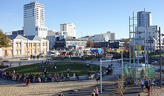
Christchurch Central City or Christchurch City Centre is the geographical centre and the heart of Christchurch, New Zealand. It is defined as the area within the Four Avenues and thus includes the densely built up central city, some less dense surrounding areas of residential, educational and industrial usage, and green space including Hagley Park, the Christchurch Botanic Gardens and the Barbadoes Street Cemetery.

<span class="mw-page-title-main">Canterbury Earthquake Recovery Authority</span>

The Canterbury Earthquake Recovery Authority was the public service department of New Zealand charged with coordinating the rebuild of Christchurch and the surrounding areas following the 22 February 2011 earthquake. After it was disestablished on 18 April 2016, CERA's functions were taken over by a variety of other agencies.

<span class="mw-page-title-main">Southshore, New Zealand</span> Suburb in Christchurch, New Zealand

Southshore is an eastern suburb within Christchurch, New Zealand. Although it was called Southshore informally for some years previously, it was named formally in 1955. The area was damaged in the 2011 Christchurch earthquake and 198 properties were zoned red.

<span class="mw-page-title-main">Central City Red Zone</span> Former public exclusion zone in Christchurch, New Zealand

The Central City Red Zone, also known as the CBD Red Zone, was a public exclusion zone in the Christchurch Central City implemented after the 22 February 2011 Christchurch earthquake. After February 2013, it was officially renamed the CBD Rebuild Zone by government agencies, but remained known as the Red Zone. It gradually shrank in size and the last cordons were removed on 30 June 2013, 859 days after the earthquake.

<span class="mw-page-title-main">Re:START</span> Temporary mall in Christchurch, New Zealand

Container Mall was a temporary mall built from shipping containers in Christchurch Central City, New Zealand. It was a response to the 22 February 2011 Christchurch earthquake, which destroyed most buildings in City Mall, and resulted in the central city being cordoned off from public access while buildings were being demolished. Initially considered a short-term response to the lack of permanent buildings, Re:START was popular with locals and tourists alike and remained open for business until January 2018.

<span class="mw-page-title-main">Margaret Mahy Playground</span> Playground in Christchurch, New Zealand

Mark Brownlee is a New Zealand rower.

Scott Alexander Brownlee is a New Zealand rower.

<span class="mw-page-title-main">Canterbury Earthquake National Memorial</span>

The Canterbury Earthquake National Memorial is the Crown's official memorial for those killed or seriously injured in the 22 February 2011 Christchurch earthquake. It is located on both sides of the Avon River downstream from the Montreal Street bridge. The memorial opened on 22 February 2017, the sixth anniversary of the earthquake.

<span class="mw-page-title-main">Residential red zone</span> Unhabitable areas around Christchurch, New Zealand

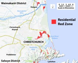
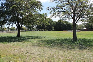
A residential red zone is any of several areas of land in and around Christchurch, New Zealand, that experienced severe damage in the 2010 and 2011 Christchurch earthquakes and were deemed infeasible to rebuild on. Through voluntary buyouts, the Crown acquired and demolished or removed over 8,000 properties. The majority were located in a broad swath of the eastern suburbs along the Avon River / Ōtākaro that had suffered damage from soil liquefaction.

<span class="mw-page-title-main">Christchurch Central Recovery Plan</span> Plan for rebuilding Christchurch after the 2011 earthquake

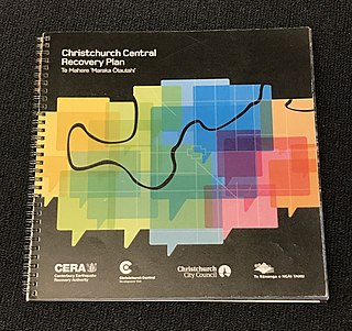
The Christchurch Central Recovery Plan, often referred to as the Blueprint, is the plan developed by the Fifth National Government of New Zealand for the recovery of the Christchurch Central City from a series of earthquakes, in particular the February 2011 Christchurch earthquake. The Canterbury Earthquake Response and Recovery Act 2010 required the Christchurch City Council to develop a recovery plan for the central city. The plan, known as Share an Idea, was presented to the Minister for Canterbury Earthquake Recovery, Gerry Brownlee, in December 2011. Brownlee rejected the city council's plan, established the Canterbury Earthquake Recovery Authority (CERA), and tasked that organisation with developing a plan based on the city council's draft. The Christchurch Central Recovery Plan was published in July 2012 and defined 17 anchor projects. All projects where a timeline was specified were to have been finished by 2017; none of the 17 projects have been delivered on time and some have not even been started yet.
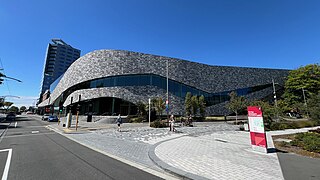
Jack Lopas is a New Zealand rower. He is nominated to compete at the 2020 Tokyo Olympics in the double sculls in a team with Chris Harris.

<span class="mw-page-title-main">Convention Centre Precinct</span> Convention Centre in Christchurch, New Zealand

The Christchurch Convention Centre Precinct is located in Christchurch Central City, New Zealand. It includes Te Pae convention centre. The construction of the precinct was funded by the Crown as part of the Christchurch Central Recovery Plan following the 2011 Christchurch earthquake.

References

  1. 1 2 "Rowing pushes new 2km course". Christchurch Mail. 8 April 2008. Retrieved 19 April 2016.
  2. 1 2 Smith, Tony (14 December 2013). "Can Christchurch become NZ's sporting capital?". The Press . Retrieved 19 April 2016.
  3. 1 2 3 "Could a water theme revitalise the east?". The Press . 18 August 2012. Retrieved 19 April 2016.
  4. 1 2 3 4 5 Stylianou, Georgina (17 April 2016). "Regenerate Christchurch to investigate red zone water course". The Press . Retrieved 19 April 2016.
  5. Evans, Hilary; Gjerde, Arild; Heijmans, Jeroen; Mallon, Bill; et al. "Mark Brownlee". Olympics at Sports-Reference.com. Sports Reference LLC. Archived from the original on 18 April 2020. Retrieved 21 September 2016.
  6. Evans, Hilary; Gjerde, Arild; Heijmans, Jeroen; Mallon, Bill; et al. "Scott Brownlee". Olympics at Sports-Reference.com. Sports Reference LLC. Archived from the original on 18 April 2020. Retrieved 21 September 2016.
  7. Dalley, Joelle (2 December 2013). "MP Gerry Brownlee makes sporting declaration". The Press . Retrieved 19 April 2016.
  8. Greenhill, Marc (25 July 2014). "Interest strong in sports lake plan". The Press . Retrieved 19 April 2016.
  9. 1 2 Cairns, Lois (6 March 2015). "Red-zone lake for water sports 'game-changer'". The Press . Retrieved 19 April 2016.
  10. Stylianou, Georgina (15 April 2016). "Gerry Brownlee's former singing partner among Regenerate Christchurch members". The Press . Retrieved 19 April 2016.
  11. "Letter of Expectations for Regenerate Christchurch" (PDF). Regenerate Christchurch. Retrieved 19 April 2016.[ permanent dead link ]
  12. Stylianou, Georgina (22 April 2016). "Concerns raised over favouritism for lake proposal". The Press . p. A2. Retrieved 26 April 2016.
  13. Small, Jamie (30 August 2017). "East Lake could pay its own way". The Press . p. A1. Retrieved 30 August 2017.
  14. Zaki, Anan (2019-08-23). "Christchurch red zone park gets green light". RNZ. Retrieved 2020-01-22.
  15. "Regenerate Christchurch will cease to exist from the end of this month". 19 June 2020. Retrieved 17 November 2020.

43°30′30″S172°40′41″E / 43.50833°S 172.67806°E / -43.50833; 172.67806