Sydenham is an inner suburb of Christchurch, New Zealand, two kilometres south of the city centre, on and around the city's main street, Colombo Street. It is a residential, retail and light industrial suburb.

TheArts Centre Te Matatiki Toi Ora is a hub for arts, culture, education, creativity and entrepreneurship in Christchurch, New Zealand. It is located in the Gothic Revival former Canterbury College, Christchurch Boys' High School and Christchurch Girls' High School buildings, many of which were designed by Benjamin Mountfort. The centre is a national landmark and taonga as it is home to New Zealand's largest collection of category one heritage buildings with 21 of the 23 buildings covered by Heritage New Zealand listings.

The Sign of the Takahe is a neo-Gothic style historic building in Christchurch, New Zealand. It is currently leased from Christchurch City Council and run as a pop in cafe, bar, and now focuses on wedding & functions.

The Addington Railway Workshops was a major railway workshops established in the Christchurch suburb of Addington in 1877 by the Public Works Department, and transferred in 1880 to the newly-formed New Zealand Railways Department (NZR). The workshops closed in 1990.

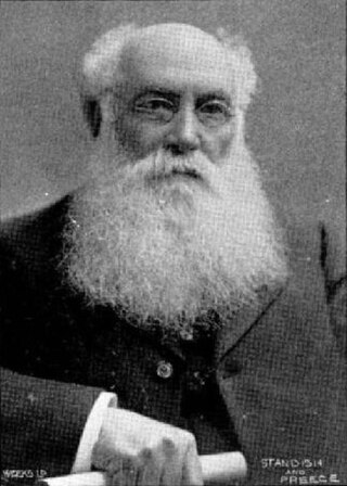
John Anderson was the second Mayor of Christchurch in New Zealand 1868–1869, and a successful businessman. He had a close connection with three buildings that have later received Category I heritage registrations by Heritage New Zealand. Two of these buildings were demolished following the February 2011 Christchurch earthquake.

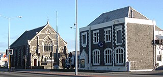
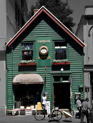
Colombo Street is a main road of the city of Christchurch, New Zealand. It runs south-north through the centre of Christchurch with a break at Cathedral Square. As with many other central Christchurch streets, it is named for a colonial Anglican bishopric, Colombo, Sri Lanka in what at the time was known as Ceylon. Parts of the street which run through Sydenham were known as Addison Street during the 1880s, and some parts were known as Colombo Road.

The Government Gardens is a public park, partly laid out as gardens, located beside Lake Rotorua in central Rotorua, Bay of Plenty, North Island, New Zealand. It was built by the government as a tourism attraction, and is still a major tourism destination in New Zealand.

Clarendon Tower was a high rise building on Worcester Street at Oxford Terrace in the Christchurch Central City, New Zealand. Built on the site of the former Clarendon Hotel, the façade of the historic building was kept in the redevelopment and was protected by the New Zealand Historic Places Trust as a Category II heritage structure. Following damage from the February 2011 Christchurch earthquake, the 17-storey building has been demolished.

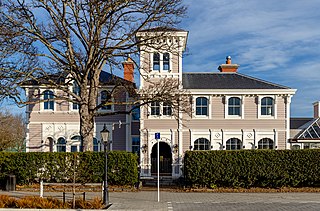
Otahuna Lodge is the former homestead of the lawyer, runholder, stock breeder, politician, horticulturist, philatelist and philanthropist Sir Heaton Rhodes (1861–1956). The grand country house is located near Tai Tapu on Banks Peninsula, New Zealand.

St Paul's Church was a heritage-listed former Presbyterian church in Cashel Street, Christchurch. Built in 1877, the church was registered by the New Zealand Historic Places Trust as a Category I heritage building. Following the February 2011 Christchurch earthquake, the building was removed from the heritage list and demolished.

Cecil Walter Wood was a New Zealand architect. He was the dominant architect in Canterbury during the interwar period.

St Saviour's at Holy Trinity is an Anglican church in Lyttelton, Christchurch, New Zealand. St Saviour's Chapel was relocated from West Lyttelton to Christchurch's Cathedral Grammar School in the 1970s. Following the earthquakes and the demolition of Holy Trinity Church, Lyttelton, St Saviour's was returned to Lyttelton to the site of Holy Trinity in 2013.

TheTrinity Church or Trinity Congregational Church designed by Benjamin Mountfort, later called the State Trinity Centre, is a Category I heritage building listed with Heritage New Zealand. Damaged in the 2010 Canterbury earthquake and red-stickered after the February 2011 Christchurch earthquake, the building was threatened with demolition like most other central city heritage buildings. In June 2012, it was announced that the building would be saved, repaired and earthquake strengthened. The building, post its church status, has housed some commercial operations, including the State Trinity Centre; 'The Octagon' (2006–2010); and later, following earthquake repairs, a business called 'The Church Brew Pub' (2023–present).
Samuel Charles Farr was a 19th-century builder and architect in Christchurch, New Zealand. He intended to emigrate from England to Auckland, but significant shipping problems saw him end up in Akaroa in 1850 instead. From 1862, he lived in Christchurch. Farr has a number of firsts against his name: the first marriage in Canterbury, he designed Akaroa's first church, designed New Zealand's first iron verandahs, and he started Sunday schools in Canterbury. As a leading member of the Acclimatisation Society, he stocked almost every lake and river in Canterbury with fish and was instrumental in introducing the bumblebee to New Zealand. His most notable building was Cranmer Court, the former Normal School, in the Christchurch Central City; this building was demolished following the February 2011 Christchurch earthquake.
The Christchurch Club is a historic private members' club in the central city of Christchurch, New Zealand. The older of the two Christchurch clubs, it was founded by rural landholders in 1856; the rival organisation, the Canterbury Club, was a breakaway that was founded by urban professionals in 1872.
The Canterbury Club is a historic gentlemen's club in the central city of Christchurch, New Zealand. It was founded by urban professionals in 1872 as a breakaway club from the Christchurch Club, which had been set up by large rural landholders in 1856.
Shand's Emporium, previously known as Gee's, is a historic building in the central city of Christchurch, New Zealand. One of the oldest commercial buildings to remain from the time Christchurch was founded, it was relocated in June 2015 from its original location in Hereford Street to Manchester Street, where it is placed adjacent to another heritage building, The Octagon.

The Community of the Sacred Name is a community of nuns in the Anglican Church in Aotearoa New Zealand and Polynesia. CSN Sisters currently live in Christchurch, Ashburton, Nukualofa and Suva. The former Motherhouse of the community including convent, chapel and novitiate stood in the central city of Christchurch, New Zealand.

Gloucester Street is a major urban street in central Christchurch in the South Island of New Zealand. It runs for approximately 4.9 kilometres (3.0 mi) from a junction with Rolleston Avenue at its western end, directly opposite Christ's College, to the suburbs of Linwood and Avonside in the east. For the majority of its length it runs due west-east, with the section from the central city's eastern edge to Linwood veering to the northeast.
