
Christchurch is the largest city in the South Island and the second-largest city by urban area population in New Zealand. Christchurch has an urban population of 415,100, and a metropolitan population of over half a million. It is located in the Canterbury Region, near the centre of the east coast of the South Island, east of the Canterbury Plains. It is located near the southern end of Pegasus Bay, and is bounded to the east by the Pacific Ocean and to the south by the ancient volcanic complex of the Banks Peninsula. The Avon River (Ōtākoro) winds through the centre of the city, with a large urban park along its banks. With the exception of the Port Hills, it is a relatively flat city, on an average around 20 m (66 ft) above sea level. Christchurch has a reputation for being an English city, with its architectural identity and nickname the 'Garden City' due to similarities with garden cities in England, but also has a historic Māori heritage. Christchurch has a temperate oceanic climate with regular moderate rainfall.
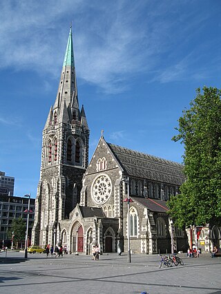
ChristChurch Cathedral, also called Christ Church Cathedral and (rarely) Cathedral Church of Christ, is a deconsecrated Anglican cathedral in the central city of Christchurch, New Zealand. It was built between 1864 and 1904 in the centre of the city, surrounded by Cathedral Square. It became the cathedral seat of the Bishop of Christchurch, who is in the New Zealand tikanga of the Anglican Church in Aotearoa, New Zealand and Polynesia.

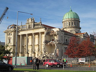
The Cathedral of the Blessed Sacrament was a Catholic cathedral located on Barbadoes Street in the city centre of Christchurch, New Zealand. It was the mother church of the Roman Catholic Diocese of Christchurch and seat of the Bishop of Christchurch.

Twinkle Toes is the largest excavator in the Southern Hemisphere. It was used in Christchurch to demolish tall buildings following the 2010 and 2011 earthquakes before moving to Wellington following the 2016 Kaikōura earthquake.

Christchurch Central City or Christchurch City Centre is the geographical centre and the heart of Christchurch, New Zealand. It is defined as the area within the Four Avenues and thus includes the densely built up central city, some less dense surrounding areas of residential, educational and industrial usage, and green space including Hagley Park, the Christchurch Botanic Gardens and the Barbadoes Street Cemetery.
A major earthquake occurred in Christchurch on Tuesday 22 February 2011 at 12:51 p.m. local time. The 6.2 earthquake struck the Canterbury region in the South Island, centred 6.7 kilometres (4.2 mi) south-east of the central business district. It caused widespread damage across Christchurch, killing 185 people in New Zealand's fifth-deadliest disaster. Scientists classified it as an intraplate earthquake and potentially an aftershock of the 2010 Canterbury earthquake.

The Hotel Grand Chancellor was a major four-star hotel in the centre of Christchurch in New Zealand, one of eleven Hotel Grand Chancellor establishments across Australia and New Zealand. The hotel was located at 161 Cashel Street, close to the city's City Mall central shopping precinct.

The implosion of Radio Network House in 2012 was the first implosion used in New Zealand to demolish a building, and was a "test case" for the potential to use such a demolition method on similar buildings in Christchurch Central City that had been damaged in the 2011 earthquake. Like most other large buildings in central Christchurch, Radio Network House was damaged beyond repair in the 2011 earthquake, and the Canterbury Earthquake Recovery Authority (CERA) added it to the demolition list in August 2011. In July 2012, it was announced that the building was going to be imploded, involving a specialist company from the United States with considerable experience in this type of work.

Cranmer Court, the former Christchurch Normal School, was one of the most significant heritage buildings in Christchurch, New Zealand. Its demolition, due to some damage in the 2011 Christchurch earthquake, was controversial.

The Central City Red Zone, also known as the CBD Red Zone, was a public exclusion zone in the Christchurch Central City implemented after the 22 February 2011 Christchurch earthquake. After February 2013, it was officially renamed the CBD Rebuild Zone by government agencies, but remained known as the Red Zone. It gradually shrank in size and the last cordons were removed on 30 June 2013, 859 days after the earthquake.

The Cardboard Cathedral, formally called the Transitional Cathedral, in Christchurch, New Zealand, is the transitional pro-cathedral of the Anglican Diocese of Christchurch, replacing ChristChurch Cathedral, which was significantly damaged in the 2011 Christchurch earthquake. The Cardboard Cathedral was designed by the Japanese architect Shigeru Ban and opened in August 2013. It is located on the site of the former St John the Baptist Church on the corner of Hereford and Madras Streets in Latimer Square, several blocks from the permanent location of ChristChurch Cathedral.

Deon William Swiggs is a New Zealand politician serving as the Environment Canterbury Councillor representing the Christchurch West/Ōpuna Regional Constituency. He previously served as the Christchurch City Councillor representing the Central ward from 2016 to 2019. Prior to Swiggs being elected, he was most well known for his participation in Rebuild Christchurch, an organisation founded after the 2010 Canterbury earthquake.

The Westpac Canterbury Centre was a landmark tower on the corner of High Street and Cashel Street in the center of Christchurch, New Zealand. In the early 2010s, it was considered the 9th tallest building in Christchurch, standing at 55 metres tall with 13-storeys and a basement level.

Container Mall was a temporary mall built from shipping containers in Christchurch Central City, New Zealand. It was a response to the 22 February 2011 Christchurch earthquake, which destroyed most buildings in City Mall, and resulted in the central city being cordoned off from public access while buildings were being demolished. Initially considered a short-term response to the lack of permanent buildings, Re:START was popular with locals and tourists alike and remained open for business until January 2018.

The Crowne Plaza Christchurch, formerly known as the Forsyth Barr Building, is located on the south-east corner of the Armagh and Colombo Streets intersection in Christchurch, New Zealand. Originally owned by Bob Jones and branded Robert Jones House by him, it was commonly referred to as Bob Jones Tower, but some called it Bob's Folly. In the 2011 Christchurch earthquake, its staircases collapsed, trapping the occupants. The building reopened in July 2017 as the city's Crowne Plaza hotel.

The Canterbury Public Library building, was a library in Central Christchurch and the main library of Christchurch City Libraries, New Zealand. It was the largest library in the South Island and the third-biggest in New Zealand. It was also known as the Central Library. It opened in 1982 on the corner of Oxford Terrace and Gloucester Street but was closed on the day of the 22 February 2011 Christchurch earthquake. After the earthquake temporary libraries to serve the Cental City were set up at South City Mall, Tuam Street, Manchester Street and Peterborough Street. The building was demolished in 2014 to make way for the Convention Centre Precinct. Tūranga, the replacement library, and Civic Space was opened in 2018.
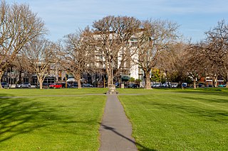
Latimer Square is an urban park in central Christchurch, New Zealand. It is located 400 metres (440 yd) east of the city's centre, Cathedral Square. Many commemorative events take place in Latimer Square. The square lies between the major urban thoroughfares of Gloucester Street and Worcester Street. Madras Street runs north and south to Latimer Square. The square is grassed and crossed by concrete paths and edged by mature trees. It covers an area of a little over 1.8 hectares.
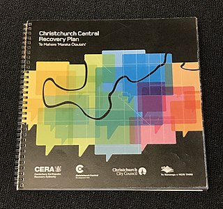
The Christchurch Central Recovery Plan, often referred to as the Blueprint, is the plan developed by the Fifth National Government of New Zealand for the recovery of the Christchurch Central City from a series of earthquakes, in particular the February 2011 Christchurch earthquake. The Canterbury Earthquake Response and Recovery Act 2010 required the Christchurch City Council to develop a recovery plan for the central city. The plan, known as Share an Idea, was presented to the Minister for Canterbury Earthquake Recovery, Gerry Brownlee, in December 2011. Brownlee rejected the city council's plan, established the Canterbury Earthquake Recovery Authority (CERA), and tasked that organisation with developing a plan based on the city council's draft. The Christchurch Central Recovery Plan was published in July 2012 and defined 17 anchor projects. All projects where a timeline was specified were to have been finished by 2017; none of the 17 projects have been delivered on time and some have not even been started yet.

The Christchurch Bus Interchange is the bus station in the Christchurch Central City in New Zealand. Built as one of the 17 anchor projects identified in the Christchurch Central Recovery Plan, it opened in May 2015 after the previous Bus Exchange had been damaged in the 2011 Christchurch earthquake.
