Christchurch is the largest city in the South Island and the second-largest city by urban area population in New Zealand. Christchurch has a population of 396,200 and is located in the Canterbury Region, near the centre of the east coast of the South Island, east of the Canterbury Plains. It is located near the southern end of Pegasus Bay, and is bounded to the east by the Pacific Ocean and to the south by the ancient volcanic complex of the Banks Peninsula. The Avon River (Ōtākoro) winds through the centre of the city, with a large urban park along its banks. With the exception of the Port Hills, it is a relatively flat city, on an average around 20 m (66 ft) above sea level. Christchurch has a reputation for being an English city, with its architectural identity and nickname the 'Garden City' due to similarities with garden cities in England. Christchurch has a temperate oceanic climate with regular moderate rainfall.

Cathedral Square, locally known simply as the Square, is the geographical centre and heart of Christchurch, New Zealand, where the city's Anglican cathedral, ChristChurch Cathedral is located. The square stands at the theoretical crossing of the city's two main orthogonal streets, Colombo Street and Worcester Street, though in practice both have been either blocked off or detoured around the square itself. The square was badly damaged in the February 2011 Christchurch earthquake.

Public transport in Christchurch, New Zealand, consists of bus services operated by two bus companies supported by a ferry, all jointly marketed as Metro, a division of Environment Canterbury (ECan).

Christchurch Central City or Christchurch City Centre is the geographical centre and the heart of Christchurch, New Zealand. It is defined as the area within the Four Avenues and thus includes the densely built up central city, some less dense surrounding areas of residential, educational and industrial usage, and green space including Hagley Park, the Christchurch Botanic Gardens and the Barbadoes Street Cemetery.

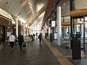
The Bus Exchange was the main public transport facility in the central city of Christchurch, New Zealand. Part of it was indoor and featured airport-style lounges. The Bus Exchange opened in November 2000 and closed due to the February 2011 Christchurch earthquake, which damaged the building beyond repair. The replacement facility, the Bus Interchange, opened across the other side of Lichfield Street in May 2015.

Colombo Street is a main road of the city of Christchurch, New Zealand. It runs south-north through the centre of Christchurch with a break at Cathedral Square. As with many other central Christchurch streets, it is named for a colonial Anglican bishopric, Colombo, Sri Lanka in what at the time was known as Ceylon. Parts of the street which run through Sydenham were known as Addison Street during the 1880s, and some parts were known as Colombo Road.

The Canterbury Earthquake Recovery Authority was the public service department of New Zealand charged with coordinating the rebuild of Christchurch and the surrounding areas following the 22 February 2011 earthquake. After it was disestablished on 18 April 2016, CERA's functions were taken over by a variety of other agencies.

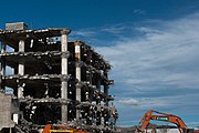
The implosion of Radio Network House in 2012 was the first implosion used in New Zealand to demolish a building, and was a "test case" for the potential to use such a demolition method on similar buildings in Christchurch Central City that had been damaged in the 2011 earthquake. Like most other large buildings in central Christchurch, Radio Network House was damaged beyond repair in the 2011 earthquake, and the Canterbury Earthquake Recovery Authority (CERA) added it to the demolition list in August 2011. In July 2012, it was announced that the building was going to be imploded, involving a specialist company from the United States with considerable experience in this type of work.

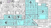
The Central City Red Zone, also known as the CBD Red Zone, was a public exclusion zone in the Christchurch Central City implemented after the 22 February 2011 Christchurch earthquake. After February 2013, it was officially renamed the CBD Rebuild Zone by government agencies, but remained known as the Red Zone. It gradually shrank in size and the last cordons were removed on 30 June 2013, 859 days after the earthquake.

Container Mall was a temporary mall built from shipping containers in Christchurch Central City, New Zealand. It was a response to the 22 February 2011 Christchurch earthquake, which destroyed most buildings in City Mall, and resulted in the central city being cordoned off from public access while buildings were being demolished. Initially considered a short-term response to the lack of permanent buildings, Re:START was popular with locals and tourists alike and remained open for business until January 2018.

Stay are identical cast iron human form sculptures made by Antony Gormley and installed in two locations in the central city of Christchurch, New Zealand. The first sculpture was installed in the Avon River in September 2015. The second in the Northern Quadrangle of the Christchurch Arts Centre was unveiled on 1 October 2016.

The Crowne Plaza Christchurch, formerly known as the Forsyth Barr Building, is located on the south-east corner of the Armagh and Colombo Streets intersection in Christchurch, New Zealand. Originally owned by Bob Jones and branded Robert Jones House by him, it was commonly referred to as Bob Jones Tower, but some called it Bob's Folly. In the 2011 Christchurch earthquake, its staircases collapsed, trapping the occupants. The building reopened in July 2017 as the city's Crowne Plaza hotel.
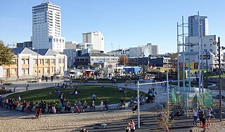
The Margaret Mahy Playground – Tākaro ā Poi is a playground in the Christchurch Central City on the banks of the Avon River.

The Canterbury Public Library building, was a library in Central Christchurch and the main library of Christchurch City Libraries, New Zealand. It was the largest library in the South Island and the third-biggest in New Zealand. It was also known as the Central Library. It opened in 1982 on the corner of Oxford Terrace and Gloucester Street but was closed on the day of the 22 February 2011 Christchurch earthquake. After the earthquake temporary libraries to serve the Cental City were set up at South City Mall, Tuam Street, Manchester Street and Peterborough Street. The building was demolished in 2014 to make way for the Convention Centre Precinct. Tūranga, the replacement library, and Civic Space was opened in 2018.

The Canterbury Earthquake National Memorial is the Crown's official memorial for those killed or seriously injured in the 22 February 2011 Christchurch earthquake. It is located on both sides of the Avon River downstream from the Montreal Street bridge. The memorial opened on 22 February 2017, the sixth anniversary of the earthquake.

Tūranga is the largest public library located in Central Christchurch, New Zealand. It opened on 12 October 2018 and replaced the nearby Christchurch Central Library that was closed on the day of the 2011 Christchurch earthquake.
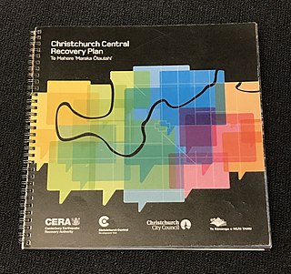
The Christchurch Central Recovery Plan, often referred to as the Blueprint, is the plan developed by the Fifth National Government of New Zealand for the recovery of the Christchurch Central City from a series of earthquakes, in particular the February 2011 Christchurch earthquake. The Canterbury Earthquake Response and Recovery Act 2010 required the Christchurch City Council to develop a recovery plan for the central city. The plan, known as Share an Idea, was presented to the Minister for Canterbury Earthquake Recovery, Gerry Brownlee, in December 2011. Brownlee rejected the city council's plan, established the Canterbury Earthquake Recovery Authority (CERA), and tasked that organisation with developing a plan based on the city council's draft. The Christchurch Central Recovery Plan was published in July 2012 and defined 17 anchor projects. All projects where a timeline was specified were to have been finished by 2017; none of the 17 projects have been delivered on time and some have not even been started yet.

Te Kaha, also known as the Canterbury Multi-Use Arena, and as One New Zealand Stadium for sponsorship reasons is a multi-use sports arena in Christchurch, New Zealand. It is situated on land bordered by Hereford, Madras, Tuam, and Barbadoes Streets. The facility is designed as a replacement for Lancaster Park, which was damaged in the 2011 Christchurch earthquake and demolished in 2019. The stadium is part of the Christchurch Central Recovery Plan developed by the government in 2012, and is scheduled to open in April 2026.
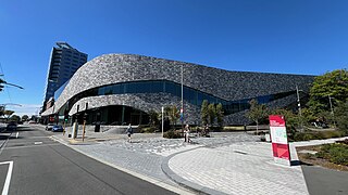
Te Pae Christchurch Convention Centre is a convention centre located in Christchurch Central City, New Zealand. The centre is a replacement for the previous Christchurch Convention Centre that was demolished after the 2011 Christchurch earthquake. Originally known as the Convention Centre Precinct, construction was funded by the New Zealand Government as part of the Christchurch Central Recovery Plan. The centre is owned by the Crown through Rau Paenga Crown Infrastructure Delivery Ltd state-owned enterprise, and managed by ASM Global. The polysemous name Te Pae is "inspired" by the Māori language, and can roughly be interpreted to mean "gathering place".

