
Māngere Bridge, officially also called the Manukau Harbour Crossing, is a dual motorway bridge over the Manukau Harbour in south-western Auckland, New Zealand, crossing between the suburb also known as Māngere Bridge and the suburb of Onehunga.

Waitematā railway station, formerly known as Britomart Transport Centre, is the public transport hub in the central business district of Auckland and the northern terminus of the North Island Main Trunk railway line. It combines a railway station in a former Edwardian post office, extended with expansive modernist architectural elements, with a bus interchange. It is at the foot of Queen Street, the main commercial thoroughfare of the CBD, with the main ferry terminal just across Quay Street.
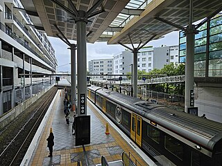
Newmarket railway station is a station in the inner-city suburb of Newmarket in Auckland, New Zealand. It serves the Southern, Onehunga and Western Lines of the Auckland railway network, and is the second-busiest station in Auckland, after Waitematā.

The Onehunga Branch railway line is a section of the Onehunga Line in Auckland, New Zealand. It was constructed by the Auckland Provincial Government and opened from Penrose to Onehunga on 24 December 1873, and extended to Onehunga Wharf on 28 November 1878. It is 3.6 kilometres (2.2 mi) in length and is single-track only.

The Central Motorway Junction or CMJ, is the intersection of State Highways 1 and 16, just south of the central business district of Auckland. A multilevel structure, it has been described as a "fiendishly complicated, multi-layered puzzle of concrete, steel and asphalt". Carrying around 200,000 vehicles a day, it is one of the busiest stretches of road in New Zealand.
Transport in Auckland, New Zealand's largest city, is defined by factors that include the shape of the Auckland isthmus, the suburban character of much of the urban area, a history of focusing investment on roading projects rather than public transport, and high car-ownership rates.

Grafton Bridge is a road bridge spanning Grafton Gully in Auckland, New Zealand. Built of reinforced concrete in 1910, it connects the Auckland CBD and Karangahape Road with Grafton. It spans about 97.6 metres, rises 25.6 metres above the abutments to a height of around 43 metres over the gully. When the bridge was constructed, it contained the largest reinforced concrete arch in the world.

Grafton Gully is a deep and very wide gully running northwards towards the sea through the volcanic hills of the Auckland volcanic field in New Zealand. It divides the CBD from the suburbs of Grafton and Parnell in the east.

Public transport in Auckland, the largest metropolitan area of New Zealand, consists of three modes: bus, train and ferry. Services are coordinated by Auckland Transport (AT) under the AT and AT Metro brands. Waitematā Station is the city's main transport hub.

The Avondale–Southdown Line is a proposed railway line between Avondale and Southdown in Auckland, New Zealand. One of its main functions would be to remove north–south freight trains from parts of the Auckland rail system that have significant passenger traffic.

The Newmarket Viaduct is a seven-lane state highway viaduct in Auckland, New Zealand. The 700 m long viaduct, which is up to 20 m high, carries the Southern Motorway over the Newmarket suburb.
The Western Line in Auckland, New Zealand, is the name given to suburban rail services that operate between Waitematā and Swanson via Newmarket.
The Manukau Branch is a 2.5 kilometres (1.6 mi) spur railway line off the North Island Main Trunk railway from Wiri to Manukau City Centre in Auckland, New Zealand. It is the first fully new section of railway line constructed in Auckland since the Eastern Line in 1930. From Manukau, the branch connects to the NIMT in the north facing direction only.

The Second Harbour Crossing is the name given to the proposed second transport link across the Waitematā Harbour in Auckland, New Zealand. Planners have also referred to new links across the harbour as the Additional Waitematā Harbour Crossing (AWHC) or the Waitematā Harbour Connections.

Auckland railway electrification occurred in phases as part of investment in a new infrastructure for Auckland's urban railway network. Electrification of the network had been proposed for several decades. Installation started in the late 2000s after funds were approved from a combination of regional and central government budgets.

The Northwestern Cycleway, sometimes also referred to as the North West or Northwestern Cycle Route, is a 12 km mostly off-road cycle route in New Zealand that connects the Auckland CBD with the suburb of Westgate. For most of its length, it runs alongside the Northwestern Motorway.
The Western Ring Route is a motorway system in Auckland, New Zealand. It runs along the entire Southwestern Motorway, most of the Northwestern Motorway, the entire Upper Harbour Motorway, and the entire Upper Harbour Highway. When the Upper Harbour Highway is upgraded to motorway status, the route will surpass the Southern Motorway to become the longest motorway in New Zealand at 48 kilometres in length. It runs through Manukau, West Auckland, and the North Shore, bypassing the Auckland city centre and thus providing a second motorway route through the Auckland isthmus.

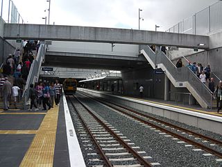
Grafton railway station is a station serving the inner-city suburb of Grafton in Auckland, New Zealand. It is located on the Western Line of Auckland's passenger rail network and consists of an island platform located in a trench near the intersection of Khyber Pass Road and Park Road. The station opened on 11 April 2010.

The City Rail Link (CRL) is a rail project currently under construction in Auckland, New Zealand. The project consists of a 3.5 km (2.2 mi) long double-track rail tunnel underneath Auckland's city centre, between Waitematā (Britomart) and Maungawhau railway stations. Two new underground stations will be constructed to serve the city centre: Te Waihorotiu near Aotea Square and Karanga-a-Hape near Karangahape Road. Waitematā will be converted from a terminus station into a through station, and Mount Eden station will be replaced by Maungawhau station, a new station with four platforms to serve as an interchange between the new CRL line and the existing Western Line.
The Auckland Airport Line is a proposed heavy rail line in Auckland, New Zealand, that would link Auckland Airport with the Auckland central business district via central isthmus suburbs.


