
New Brighton is a coastal suburb of Christchurch, New Zealand, 8 kilometres (5.0 mi) east of the city centre. It is one of eastern Christchurch's main entertainment and tourist centres, with its architecturally unique pier and scenic coastline. The 2011 Christchurch earthquakes caused significant damage in the area.

The Ashley River is in the Canterbury region of New Zealand. It flows generally southeastwards for 65 kilometres (40 mi) before entering the Pacific Ocean at Waikuku Beach, Pegasus Bay north of Christchurch. The town of Rangiora is close to the south bank of the Ashley River. The river's official name was changed from Ashley River to the dual name Ashley River / Rakahuri by the Ngāi Tahu Claims Settlement Act 1998.

The Christchurch City Council is the local government authority for Christchurch in New Zealand. It is a territorial authority elected to represent the 396,200 people of Christchurch. Since October 2022, the Mayor of Christchurch is Phil Mauger, who succeeded after the retirement of Lianne Dalziel. The council currently consists of 16 councillors elected from sixteen wards, and is presided over by the mayor, who is elected at large. The number of elected members and ward boundaries changed prior to the 2016 election.

The Cathedral of the Blessed Sacrament was a Catholic cathedral located on Barbadoes Street in the city centre of Christchurch, New Zealand. It was the mother church of the Roman Catholic Diocese of Christchurch and seat of the Bishop of Christchurch.

The Music Centre of Christchurch was a facility for music organisations in the central city of Christchurch, New Zealand. It was established in 1994 and provided office, rehearsal, tuition and performance space for a wide range of music groups. The centre was adjacent to the Cathedral of the Blessed Sacrament and consisted of a group of four heritage buildings formerly the convent of the Sisters of Our Lady of the Missions and Sacred Heart College, a Catholic secondary school for girls founded in 1881 which was amalgamated with Xavier College, a neighbouring Catholic boys' school to form Catholic Cathedral College in 1987.

John Anderson was the second Mayor of Christchurch in New Zealand 1868–1869, and a successful businessman. He had a close connection with three buildings that have later received Category I heritage registrations by Heritage New Zealand. Two of these buildings were demolished following the February 2011 Christchurch earthquake.

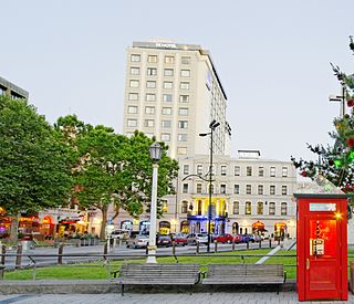
The Hotel Grand Chancellor was a major four-star hotel in the centre of Christchurch in New Zealand, one of eleven Hotel Grand Chancellor establishments across Australia and New Zealand. The hotel was located at 161 Cashel Street, close to the city's City Mall central shopping precinct.

The Lyttelton Timeball Station is a heritage-registered time ball station and prominent local landmark in Lyttelton, New Zealand. The original station was significantly damaged by a series of earthquakes and aftershocks in 2010 and 2011, and finally collapsed on 13 June 2011 after a magnitude 6.4 aftershock. The tower was subsequently reconstructed, reopening in November 2018.
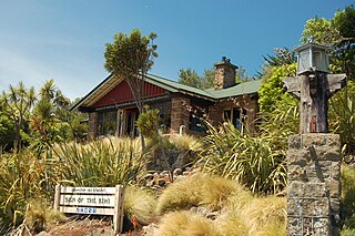
The Sign of the Kiwi, originally called Toll House, is a small café and shop at Dyers Pass on the road between Christchurch and Governors Bay. It was built in 1916–17 by Harry Ell as a staging post and opened as a tearoom and rest house. It has a Category I heritage classification by Heritage New Zealand and is a popular destination for tourists and locals alike. The building was closed some time after the 22 February 2011 Christchurch earthquake and did not open again until 23 January 2017, six years later. Although located within the burned area, the building was not damaged by the 2017 Port Hills fires a month later.
Warner's Hotel in 50 Cathedral Square, Christchurch is the site of a hotel established in 1863. The original building, extended on numerous occasions, burned down in 1900. A new building was built in 1901. Again, it underwent numerous alterations. A fourth storey was added in 1910 and the northern end of the building was demolished in 1917 and a theatre built in its place to create a noise buffer to the printing presses of the adjoining Lyttelton Times Building. The theatre was demolished in 1996 and patrons enjoyed a beer garden. In 2010, a high-rise Novotel hotel opened on the site of the beer garden and in the process, the historical and symmetrical 1901 façade was recreated.

The implosion of Radio Network House in 2012 was the first implosion used in New Zealand to demolish a building, and was a "test case" for the potential to use such a demolition method on similar buildings in Christchurch Central City that had been damaged in the 2011 earthquake. Like most other large buildings in central Christchurch, Radio Network House was damaged beyond repair in the 2011 earthquake, and the Canterbury Earthquake Recovery Authority (CERA) added it to the demolition list in August 2011. In July 2012, it was announced that the building was going to be imploded, involving a specialist company from the United States with considerable experience in this type of work.

The Westpac Canterbury Centre was a landmark tower on the corner of High Street and Cashel Street in the center of Christchurch, New Zealand. Prior to the February 2011 earthquake, it was considered the 9th tallest building in Christchurch, standing at 55 metres tall.

The Hornby Clocktower was an iconic Christchurch building, situated in the suburb of Hornby on New Zealand State Highway 1. It marked the southern entrance to Christchurch for over 50 years.

New Regent Street is a pedestrian mall in Christchurch. Built as a private development in the early 1930s with 40 shops in Spanish Mission architectural style, it is one of the city's major tourist attractions. Providing a number of small shops as a comprehensive development was an advanced idea at the time, and New Regent Street is regarded as a forerunner to modern shopping malls. Due to its coherent architectural character, the buildings in the streets are listed as Category I heritage items by Heritage New Zealand, and in addition, the entire street has a historic area listing. The street was pedestrianised in 1994 in preparation for the introduction of the Christchurch heritage tram, which began operation in February 1995. Damaged in the February 2011 Christchurch earthquake, the street and buildings reopened in April 2013, and the tram returned from November of that year. Following the 2016 Valentine's Day earthquake, five of the buildings that had not been repaired after the previous earthquakes had been cordoned off, which stopped the tram from operating on its original heritage loop until May.

The Christchurch Gondola is a tourist attraction service offered by Christchurch Attractions in Christchurch, New Zealand. The gondola base is located in Heathcote Valley, and it traverses the slopes of Mount Cavendish in the Port Hills. Also known as a cable car, the Christchurch Gondola's course is 1,000 metres (1,100 yd) in length, and from the summit it is possible to see across the city of Christchurch and the Canterbury Plains to the Southern Alps in the north and west, and down into Lyttelton Harbour and Banks Peninsula in the south and east. Sometimes used as a transport method for visitors who use the walking tracks on Mt Cavendish, the gondola is ranked as one of the top tourist attractions in Christchurch by TripAdvisor. The summit is 445 metres (1,460 ft) above sea level.

The 2016 Kaikōura earthquake was a 7.8 earthquake in the South Island of New Zealand that occurred two minutes after midnight on 14 November 2016 NZDT. Ruptures occurred on multiple faults and the earthquake has been described as the "most complex earthquake ever studied". It has been subsequently modelled as having a megathrust component set off by an adjacent rupture on the Humps Fault. It was the second largest earthquake in New Zealand since European settlement.

Riccarton House is an historic building in Christchurch, New Zealand. It is part of the Riccarton estate, the first area in Christchurch lived in by British settlers, after which the suburb of Riccarton is named. The house was commissioned by Jane Deans, the widow of Canterbury pioneer John Deans, and finished in 1856. It was twice extended; first in 1874, and the work carried out in 1900 more than doubled the size of the house. The Riccarton estate has in stages become the property of Christchurch City Council and Riccarton House itself was sold by the Deans family to the city in 1947. Damaged by the earthquakes in 2010 and 2011, the repaired and renovated building was reopened in June 2014. Riccarton House is used as a restaurant and for functions, and a popular market is held on Saturdays in front of it.
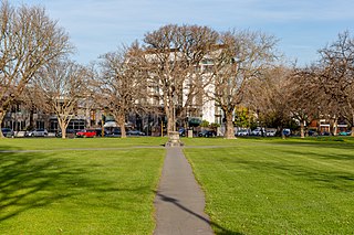
Latimer Square is an urban park in central Christchurch, New Zealand. It is located 400 metres (440 yd) east of the city's centre, Cathedral Square. Many commemorative events take place in Latimer Square. The square lies between the major urban thoroughfares of Gloucester Street and Worcester Street. Madras Street runs north and south to Latimer Square. The square is grassed and crossed by concrete paths and edged by mature trees. It covers an area of a little over 1.8 hectares.

The Christchurch Wastewater Treatment Plant (CWTP), also known as the Bromley sewage plant, is the main wastewater treatment plant of Christchurch, New Zealand. It is located in the suburb of Bromley, adjacent to the Avon Heathcote Estuary. Opened in 1962, it replaced an earlier sewage disposal farm that had operated since 1882. In late 2021, two trickling filters burned down and adjacent suburbs have since been subjected to a putrid smell.


