Canterbury is a region of New Zealand, located in the central-eastern South Island. The region covers an area of 44,503.88 square kilometres (17,183.04 sq mi), making it the largest region in the country by area. It is home to a population of 666,300.

Gerard Anthony Brownlee is a New Zealand politician and the 32nd speaker of the New Zealand House of Representatives. He was first elected as a member of the New Zealand House of Representatives for Ilam in 1996, representing the National Party. He became a list MP in 2020.

Christchurch is the largest city in the South Island and the second-largest city by urban area population in New Zealand. Christchurch has a population of 396,200 and is located in the Canterbury Region, near the centre of the east coast of the South Island, east of the Canterbury Plains. It is located near the southern end of Pegasus Bay, and is bounded to the east by the Pacific Ocean and to the south by the ancient volcanic complex of the Banks Peninsula. The Avon River (Ōtākoro) winds through the centre of the city, with a large urban park along its banks. With the exception of the Port Hills, it is a relatively flat city, on an average around 20 m (66 ft) above sea level. Christchurch has a reputation for being an English city, with its architectural identity and nickname the 'Garden City' due to similarities with garden cities in England. Christchurch has a temperate oceanic climate with regular moderate rainfall.
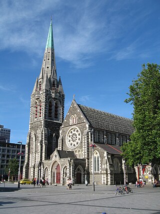
ChristChurch Cathedral, also called Christ Church Cathedral and (rarely) Cathedral Church of Christ, is a deconsecrated Anglican cathedral in the city of Christchurch, New Zealand. It was built between 1864 and 1904 in the centre of the city, surrounded by Cathedral Square. It became the cathedral seat of the Bishop of Christchurch, who is in the New Zealand tikanga of the Anglican Church in Aotearoa, New Zealand and Polynesia.

Nicola Joanne Wagner is a New Zealand teacher, businesswoman and politician. She represented the Christchurch Central electorate for the New Zealand National Party in the New Zealand Parliament.

Canterbury Television was an independent television station broadcasting in Canterbury, New Zealand.

Sir Robert John Parker is a former New Zealand broadcaster and politician. He served as Mayor of Christchurch from 2007 to 2013.
Natural Hazards Commission – Toka Tū Ake, also known as the Earthquake Commission Toka Tū Ake, is a New Zealand Crown entity that invests in natural disaster research and education as well as providing natural disaster insurance to residential property owners. The Natural Hazards Insurance Act 2023, which came into effect on 1 July 2024, made a number of changes, including changing the name of the Earthquake Commission to Natural Hazards Commission.
The following lists events that happened during 2011 in New Zealand.
The 2010 Canterbury earthquake struck the South Island of New Zealand with a moment magnitude of 7.1 at on 4 September, and had a maximum perceived intensity of X (Extreme) on the Mercalli intensity scale. Some damaging aftershocks followed the main event, the strongest of which was a magnitude 6.3 shock known as the Christchurch earthquake that occurred nearly six months later on 22 February 2011. Because this aftershock was centred very close to Christchurch, it was much more destructive and resulted in the deaths of 185 people.

Hororata is a village at the northwestern edge of the Canterbury Plains in the South Island of New Zealand. It is located 15 kilometres southwest of Darfield, five kilometres south of Glentunnel, and 50 kilometres west of Christchurch, on the banks of the Hororata River. Hororata, when translated from Maori means "drooping rata". There are a large number of rata growing in the district.
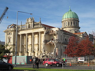
A major earthquake occurred in Christchurch on Tuesday 22 February 2011 at 12:51 p.m. local time. The 6.2 earthquake struck the Canterbury region in the South Island, centred 6.7 kilometres (4.2 mi) south-east of the central business district. It caused widespread damage across Christchurch, killing 185 people in New Zealand's fifth-deadliest disaster.

The Canterbury Earthquake Recovery Authority was the public service department of New Zealand charged with coordinating the rebuild of Christchurch and the surrounding areas following the 22 February 2011 earthquake. After it was disestablished on 18 April 2016, CERA's functions were taken over by a variety of other agencies.

The June 2011 Christchurch earthquake was a shallow magnitude 6.0 earthquake that occurred on 13 June 2011 at 14:20 NZST. It was centred at a depth of 7 km (4.3 mi), about 5 km (3 mi) south-east of Christchurch, which had previously been devastated by a magnitude 6.2 MW earthquake in February 2011. The June quake was preceded by a magnitude 5.9 ML tremor that struck the region at a slightly deeper 8.9 km (5.5 mi). The United States Geological Survey reported a magnitude of 6.0 Mw and a depth of 9 km (5.6 mi).

The Canterbury Earthquake National Memorial is the Crown's official memorial for those killed or seriously injured in the 22 February 2011 Christchurch earthquake. It is located on both sides of the Avon River downstream from the Montreal Street bridge. The memorial opened on 22 February 2017, the sixth anniversary of the earthquake.

The Canterbury Earthquake Commemoration Day Act 2011 is an Act of Parliament passed into law in New Zealand in 2011. It created a one-off public holiday in parts of Canterbury to commemorate the effects of the Canterbury earthquakes, starting with the first shock on 4 September 2010, but in particular the aftershock on 22 February 2011 that killed 185 people.
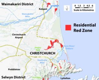
A residential red zone is any of several areas of land in and around Christchurch, New Zealand, that experienced severe damage in the 2010 and 2011 Christchurch earthquakes and were deemed infeasible to rebuild on. Through voluntary buyouts, the Crown acquired and demolished or removed over 8,000 properties. The majority were located in a broad swath of the eastern suburbs along the Avon River / Ōtākaro that had suffered damage from soil liquefaction.
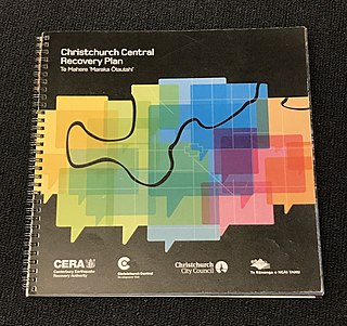
The Christchurch Central Recovery Plan, often referred to as the Blueprint, is the plan developed by the Fifth National Government of New Zealand for the recovery of the Christchurch Central City from a series of earthquakes, in particular the February 2011 Christchurch earthquake. The Canterbury Earthquake Response and Recovery Act 2010 required the Christchurch City Council to develop a recovery plan for the central city. The plan, known as Share an Idea, was presented to the Minister for Canterbury Earthquake Recovery, Gerry Brownlee, in December 2011. Brownlee rejected the city council's plan, established the Canterbury Earthquake Recovery Authority (CERA), and tasked that organisation with developing a plan based on the city council's draft. The Christchurch Central Recovery Plan was published in July 2012 and defined 17 anchor projects. All projects where a timeline was specified were to have been finished by 2017; none of the 17 projects have been delivered on time and some have not even been started yet.
On 26 December 2010 a Mw 4.7 earthquake occurred directly under the city centre of Christchurch, New Zealand, at a depth of 5 km (3.1 mi) or 4 km (2.5 mi). It caused "significant damage" to Christchurch and was part of the earthquake sequence beginning with the September 2010 Canterbury earthquake, and followed by the 2011 Christchurch earthquake.