
The 1999 Düzce earthquake occurred on 12 November at with a moment magnitude of 7.2 and a maximum Mercalli intensity of IX (Violent), causing damage and at least 845 fatalities in Düzce, Turkey. The epicenter was approximately 100 km (62 mi) to the east of the extremely destructive 1999 İzmit earthquake that happened nearly three months earlier. Both strike-slip earthquakes were caused by movement on the North Anatolian Fault.

The 2007 Gisborne earthquake occurred under the Pacific Ocean about 50 kilometres (31 mi) off the eastern coast of New Zealand's North Island at 8:55 pm NZDT on 20 December. With a moment magnitude of 6.7 and maximum Mercalli intensity of VII, the tremor affected the city of Gisborne and was felt widely throughout the country, from Auckland in the north to Dunedin in the south.
The 1888 North Canterbury earthquake occurred at 4:10 am on 1 September following a sequence of foreshocks that started the previous evening, and whose epicentre was in the North Canterbury region of the South Island of New Zealand. The epicentre was approximately 35 kilometres (22 mi) west of Hanmer.
The 1855 Wairarapa earthquake occurred on 23 January at about 9.17 p.m., affecting much of the Cook Strait area of New Zealand, including Marlborough in the South Island and Wellington and the Wairarapa in the North Island. In Wellington, close to the epicentre, shaking lasted for at least 50 seconds. The moment magnitude of the earthquake has been estimated as 8.2, the most powerful recorded in New Zealand since systematic European colonisation began in 1840. This earthquake was associated with the largest directly observed movement on a strike-slip fault, maximum 18 metres (59 ft). This was later revised upward to about 20 m (66 ft) slip, with a local peak of 8 m (26 ft) vertical displacement on lidar studies. It has been suggested that the surface rupture formed by this event helped influence Charles Lyell to link earthquakes with rapid movement on faults.
The 1848 Marlborough earthquake was a 7.5 earthquake that occurred at 1:40 a.m. on 16 October 1848 and whose epicentre was in the Marlborough region of the South Island of New Zealand.
The 1929 Arthur's Pass earthquake occurred at on 9 March. The sparsely settled region around Arthur's Pass of the Southern Alps shook for four minutes. Tremors continued almost continuously until midnight and sporadic strong aftershocks were felt for several days.

The Damghan earthquake or the Qumis earthquake occurred on 22 December 856. The earthquake had an estimated magnitude of 7.9, and a maximum intensity of X (Extreme) on the Mercalli intensity scale. The meizoseismal area extended for about 350 kilometres (220 mi) along the southern edge of the eastern Alborz mountains of present-day Iran including parts of Tabaristan and Gorgan. The earthquake's epicenter is estimated to be close to the city of Damghan, which was then the capital of the Persian province of Qumis. It caused approximately 200,000 deaths and is listed by the United States Geological Survey as the sixth deadliest earthquake in recorded history. This death toll has been debated.
The 1969 Yangjiang earthquake occurred on 26 July, at 6:49 am, Beijing local time. It had a magnitude of 6.4 on the moment magnitude scale and a maximum perceived intensity of VIII (Severe) on the Mercalli intensity scale. It struck the city of Yangjiang, causing over 10,700 houses to collapse and severely damaging a further 36,000. The earthquake also caused landslides and sandblows observed along the coast and along some rivers in the area of Yangjiang. The earthquake was also felt in Hong Kong. There were an unconfirmed total of 3,000 deaths.
The 1929 Murchison earthquake occurred at 10:17 am on 17 June. It struck the Murchison region of the South Island, with an estimated magnitude of 7.3, and was felt throughout New Zealand. There were 17 deaths, mostly as a result of landslides triggered by the earthquake. The rumbling sound of the earthquake was loud enough to be heard at New Plymouth, more than 250 km (155 mi) away.

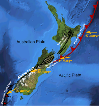
The Marlborough fault system is a set of four large dextral strike-slip faults and other related structures in the northern part of the South Island, New Zealand, which transfer displacement between the mainly transform plate boundary of the Alpine fault and the mainly destructive boundary of the Kermadec Trench, and together form the boundary between the Australian and Pacific plates.
The Clarence Fault is an active dextral strike-slip fault in the northeastern part of South Island, New Zealand. It forms part of the Marlborough fault system, which accommodates the transfer of displacement along the oblique convergent boundary between the Indo-Australian plate and Pacific plate, from the transform Alpine Fault to the Hikurangi Trough subduction zone.

The 1976 Çaldıran–Muradiye earthquake occurred at 14:22 local time on 24 November. The epicenter was located near Çaldıran, 20 km northeast of Muradiye, in the Van Province of eastern Turkey. The earthquake had a magnitude of 7.3 with a maximum intensity of X (Extreme) on the Mercalli intensity scale. The area of severe damage, where over 80% of the buildings were destroyed, covered an area of 2,000 square kilometres. There were between 4,000 and 5,000 casualties.
The North Island Fault System (NIFS) is a set of southwest–northeast trending seismically-active faults in the North Island of New Zealand that carry much of the dextral strike-slip component of the oblique convergence of the Pacific Plate with the Australian Plate. However despite at least 3 km (1.9 mi) of uplift of the axial ranges in the middle regions of the fault system during the last 10 million years most of the shortening on this part of the Hikurangi Margin is accommodated by subduction.
The 1762 Arakan earthquake occurred at about 17:00 local time on 2 April, with an epicentre somewhere along the coast from Chittagong to Arakan in modern Myanmar. It had an estimated moment magnitude between 8.5 and 8.8 and a maximum estimated intensity of XI (Extreme). It triggered a local tsunami in the Bay of Bengal and caused at least 200 deaths. The earthquake was associated with major areas of both uplift and subsidence. It is also associated with a change in course of the Brahmaputra River to from east of Dhaka to 150 kilometres (93 mi) to the west via the Jamuna River.
The 2014 Eketāhuna earthquake struck at 3:52 pm on 20 January, centred 15 km east of Eketāhuna in the south-east of New Zealand's North Island. It had a maximum perceived intensity of VII on the Mercalli intensity scale. The magnitude 6.2 earthquake was followed by a total of 1,112 recorded aftershocks, ranging between magnitudes 2.0 and 4.9.
The 1934 Pahiatua earthquake struck at 11:46 pm on 5 March, causing severe damage in much of the lower North Island. Wairarapa, Wellington and Hawke's Bay felt the strongest levels of shaking, with much of New Zealand feeling the tremor.
The 1904 Cape Turnagain earthquake struck 10 kilometres (6.2 mi) north of Cape Turnagain on the morning of 9 August with a magnitude estimated at 6.8 and 7.0–7.2 . It was felt throughout the North Island and upper South Island, with many communities within a 500 kilometres (310 mi) radius reporting noticeable ground shaking. Heavy damage occurred to the landscape and personal property and one man died. It was the largest to strike New Zealand since the 7.0 Mw North Canterbury earthquake in 1888.
The 1780 Tabriz earthquake occurred at 01:15 local time on 8 January. It had an estimated magnitude of 7.4 and a maximum felt intensity of IX on the Mercalli intensity scale. The city of Tabriz was almost completely destroyed. The number of reported casualties varies from 40,000 to as many as 200,000, with 50,000 being a more likely estimate.
In 1914, two earthquakes shook the upper North Island of New Zealand, on Wednesday 7 October and Wednesday 28 October. They were large and shallow, with their epicentres close together northwest of Ruatoria in the Gisborne District. The earthquakes were felt strongly throughout the East Cape area, most noticeably in areas east of the epicentre such as Waipiro Bay, with a large amount of damage occurring in Tokomaru Bay in particular. One person was killed by a landslide near Cape Runaway.
The 1983 Kaoiki earthquake struck southern Hawaii Island on the morning of November 16, 1983. Measuring Mw 6.7, it was the largest to hit the island since 1975. The epicenter was located 50 km (30 mi) southeast of Hilo with an approximated depth of 12 km (7 mi). The shallow strike-slip earthquake was assigned a maximum intensity of IX (Violent) on the Modified Mercalli scale. 6 people were injured, widespread damage and landslides were reported across the island.
