Marlborough fault system

Last updated
Marlborough fault system
Marlborough tectonic domain
MarlboroughFaultSystem.png
Map of the Marlborough fault system
Etymology Marlborough
Country New Zealand
Region Marlborough
Characteristics
Displacement Total strike-slip across system is up to 48 mm (1.9 in)/year. [1]
Tectonics
Plate Indo-Australian, Pacific
Status Active
Earthquakes 7.8 Mw 2016 Kaikōura earthquake [2]
Type Strike-slip faults
Movement Dextral/convergent, east side up
Age Albian-Meghalayan 105–0  Ma [2]
Orogeny Kaikōura
New Zealand geology database (includes faults)
Major active fault zones of New Zealand showing variation in displacement vector of Pacific Plate relative to Australian Plate along the boundary NZ faults.png
Major active fault zones of New Zealand showing variation in displacement vector of Pacific Plate relative to Australian Plate along the boundary

The Marlborough fault system (also known as Marlborough tectonic domain [2] ) is a set of four large dextral strike-slip faults and other related structures in the northern part of South Island, New Zealand, which transfer displacement between the mainly transform plate boundary of the Alpine fault and the mainly destructive boundary of the Kermadec Trench, and together form the boundary between the Australian and Pacific Plates. [3]

Contents

Geometry

The Marlborough fault system consists of four main dominantly strike-slip fault strands, which together carry almost all of the displacement associated with the plate boundary. Estimates of the rate of current displacement for total strike-slip across the system are between 39 mm (1.5 in)/year to 48 mm (1.9 in)/year. [1] This has meant up to 450 m (1,480 ft) of relative plate motion in less than 14,000 years. [4] Other smaller faults form as splays of these main faults or accommodate deformation of the crust between them, such as the Newton and Hura Faults at the western end of the Hope Fault and the Jordan Thrust that formed the Seaward Kaikōura Range. The dextral strike-slip across this zone has also involved clockwise rotation of the intervening fault blocks of about 20° since the early Pliocene. [5] The Hope Fault is the southern limit of the Marlborough fault system and faults to the south of it, even quite close by, are regarded as part of the Northern Canterbury domain. [6]

Development

It appears from the latest studies of the rupture complexity of the 2016 Kaikōura earthquake that the myriad of faults associated with deformation episodes over the past 100 million years are important to propagation of rupture in large events in the southern part of the Marlborough fault system as due to their reorientation they act as reactivated interconnections between the current major now dominant strike-slip faults. [2] Retrospective studies of the other large historic events in the Marlborough fault system show that this is not typical in the northeast or central parts of the system. [2] Such faults might include implicate reverse faults from a Gondwana subduction zone before 100 million years ago, but more definitely appear to relate to both low and high angle normal faults associated with Gondwana breakup and opening of the Tasman Sea between 105 and 60 million years ago [2] and the reverse faults associated with the uplift of the Inland Kaikōura Mountains between 35 million to 25 million years ago due to the start of convergence of the current plate boundary were created. [2]

Further analysis shows that the mutual plate movement has been all effectively accommodated in the region itself, over the last 14,000 odd years by ruptures in size, space and time of the four main fault strands. [4] Modelling the measured Hope, Clarence, Awatere and Wairau fault displacements show that they keep up, over periods of less than a 1000 years and a few tens of meters with the plate movement. [4] This was the first proof of a common assumption that had been made by some seismologists of the processes in tectonic related earthquake systems, as opposed to individual faults. [4]

An ancestral fault system formed between 25 and 8 million years ago with the full development of the Hikurangi subduction margin which was associated with marked vertical axis rotations. [2] There was progressive development of the modern Marlborough fault system after this from the north towards the south during the early Pliocene, with the Hope Fault complex forming no more than 2 million years ago and current formation to the south of the Hope Fault of a new fault complex, in response to a change in plate motions. [2] This new zone in Canterbury has been termed the Porters Pass–Amberley Fault Zone. [2] The new plate vector is significantly oblique to the Alpine Fault, causing an increased amount of convergence. A set of strike-slip faults formed to accommodate this change by taking up most of the strike-slip component. [7]

Faults

There are four main fault strands, being the Hope, Clarence, Awatere and Wairau faults, although many other smaller faults, of either strike-slip or thrust type are known.

Main faults

Hope Fault

The Hope Fault forms the southernmost part of the Marlborough fault system. The estimated slip-rate during the Holocene is 0.2–0.25 cm/year (0.079–0.098 in/year), just over half of the plate boundary displacement. At its northeastern end it links into the Jordan Thrust and most of the displacement is transferred onto that structure. It takes its name from the Hope River, which runs along one of the central fault segments. [3] The Kekerengu Fault and Jordan Thrust are closely associated with the Hope Fault. [8] It did not undergo significant rupture in the 2016 Kaikōura earthquake although there was minor motion on its seaward aspects, and some off fault uplift to its south except near the Northern Canterbury domain Conway-Charwell Fault which is parallel, and did rupture only a few hundreds of meters away. [6] After the main shock sequence there were aftershocks clustered to its south in the region of the Conway-Charwell Fault. [2]

Clarence Fault

The Clarence Fault runs from close to the Alpine Fault to about 10 km (6.2 mi) west of Ward, where it appears to terminate abruptly. A Holocene slip-rate of 0.35–0.5 cm/year (0.14–0.20 in/year) is estimated for this fault. At the surface the displacement appears to be nearly pure horizontal, but continuous uplift of the neighbouring Inner Kaikōura Range over the same period, suggests that some of the dip-slip component thought to be present at depth on the fault zone is transferred onto thrust or reverse faults under the range. [9] An extra 10° of clockwise rotation has been recognised within the block that lies northeast of the tip of the Clarence fault. [5] It takes its name from the Waiau Toa / Clarence River, which follows the fault trace in the northeastern section of the fault.

Awatere Fault

It is formed of two main segments; the Molesworth section to the southwest and the Eastern section to the northeast. The estimated recent slip-rate for the Molesworth section is 0.44 cm/year (0.17 in/year). [10] It takes its name from the Awatere River whose valley follows the fault trace along some of its length.

Wairau Fault

The Wairau Fault is sometimes regarded as a direct continuation of the Alpine Fault and may be referred to as the Alpine-Wairau Fault. It takes its name from the Wairau River, which follows the fault trace for most of its length. It has an estimated slip-rate of 0.3–0.5 cm/year (0.12–0.20 in/year). [8]

Smaller Faults

Kekerengu Fault

It is closely associated with the Hope Fault and Jordan Thrust at its south-easternmost edge and likely joins with the Clarence Fault to form the Wairarapa Fault offshore in Cook Strait. [8] [11] Before joining with the Clarence Fault, The offshore segment of the Kekerengu Fault is known as the Needles Fault. In the 7.8 (Mw ) 2016 Kaikōura earthquake [12] major rupture of both the Kekerengu Fault for 27 km (17 mi), [2] with maximum displacement 12.0 m (39.4 ft) ± 0.7 m (2 ft 4 in) [6] and the Needles Fault for 30 km (19 mi)) [2] occurred.

Elliott Fault

The dextral [13] Elliott Fault branches from the central portion of the Clarence Fault and then rejoins it. The Acheron and Dillon sinsteral faults also connect these two faults. [13]

Kelly Fault

The Kelly Fault forms a major fork of the Hope Fault from just west of Harper Pass; it forks again to the west into the Newton and Hura faults just before connecting to the Alpine Fault.

Jordan Thrust

The Jordan Thrust is a reverse fault that connects the southern end of the Kekerengu Fault to the Seaward Segment of the Hope Fault. It ruptured during the 7.8 (Mw ) 2016 Kaikōura earthquake with a component of dextral-normal displacement in contrast to its long-term reverse motion. [6] [2] This also resulted in major uplift to its coastal south east side as it approached the Papatea Fault. [6]

Fidget Fault

The dextral [13] Fidget Fault commences to the south of the Waiau Toa / Clarence River and runs along its valley initially before striking east to the south of the hill of Mackintosh Knob and intercepting the Jordan Thrust near the coast where the Jordan Thrust transitions to the Kekerengu Fault. Its eastern portion ruptured in the 2016 Kaikōura earthquake with some increased vertical displacement upwards to its north in the Seaward Kaikōura Range. [6] After the 2016 Kaikōura earthquake there was an aftershock cluster to its south. [2]

Papatea Fault

The Papatea Fault runs from the Jordan Thrust south east to Waipapa Bay where it historically was known to have a deep southeast plunge suggesting past dextral motion. In the 7.8 (Mw ) 2016 Kaikōura earthquake it had a sinistral component however and aftershocks grouped along its length and towards Kaikōura. [2] The size of the displacements were marked and second only to those along the Kekerengu Fault in this earthquake. There was up to 7.3 m (24 ft) of left-lateral displacement and 9 m (30 ft) of west side up vertical slip. [6]

Snowgrass Creek Fault

The Snowgrass Creek Fault was identified to be an active subsurface fault zone by optical displacement analysis (any surface rupture might be difficult to recognise due to mountainous location) [6] and was associated with a prominent group of aftershocks after 2016 Kaikoura earthquake. [2] It extends between the Kekerengu and Clarence faults northwest of Clarence. It trends northeast–southwest ( at about 210°) with displacement in this earthquake being mainly right lateral and it may lie within the hanging wall of a deeper fault structure. [6]

Barefell Pass Fault

This is an active dextral fault between the Clarence and Awatere faults. [13] It had a 4.8 ± 1.2 m dextral displacement in the 1848 Marlborough earthquake of the Awatere Fault. [2]

Fowlers Fault

This is an active dextral fault [13] that arises as a splay off the Alpine Fault south of where the Wairau Fault splays off, just south of the Blue Grey River and follows initially to the east its valley. The surface trace terminates to the east just beyond the Chimmney Stream before the Acheron River. There has been more recent upper crustal microseismicity in this fault than in the Clarence Fault to its south. [14]

Seismicity

All parts of the Marlborough fault system are currently seismically active. Historical earthquakes (since European settlement) have occurred on both the Hope and Awatere Faults and on the smaller Poulter Fault. Studies of the geomorphology and the use of trenching across fault strands, has identified many earthquakes that occurred during the Holocene on many parts of the fault system. [3] [9] [10] [8] The Hope Fault, which has the fastest slip rate is characterised by the shortest recurrence interval. The complexity of the 7.8 Mw 2016 Kaikōura earthquake completely redefined the understanding of the dynamics of the seismicity in the southern section of the fault system. [2] As the recent movements of all the main faults is now understood, future forecasting of major earthquakes in the area may improve. [4]

See also

Related Research Articles

<span class="mw-page-title-main">Alpine Fault</span> Right-lateral strike-slip fault, that runs almost the entire length of New Zealands South Island.

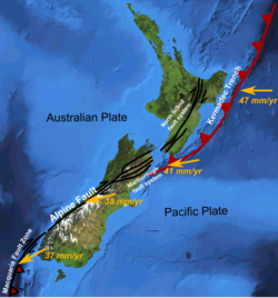
The Alpine Fault is a geological fault that runs almost the entire length of New Zealand's South Island, being about 600 km (370 mi). long, and forms the boundary between the Pacific Plate and the Australian Plate. The Southern Alps have been uplifted on the fault over the last 12 million years in a series of earthquakes. However, most of the motion on the fault is strike-slip, with the Tasman district and West Coast moving north and Canterbury and Otago moving south. The average slip rates in the fault's central region are about 38 mm (1.5 in) a year, very fast by global standards. The last major earthquake on the Alpine Fault was in about 1717 AD with a great earthquake magnitude of Mw8.1. The probability of another one occurring within the next 50 years is estimated at 75 percent.

<span class="mw-page-title-main">Hope Fault</span> Active fault in New Zealand

The Hope Fault is an active dextral strike-slip fault in the northeastern part of South Island, New Zealand. It forms part of the Marlborough Fault System, which accommodates the transfer of displacement along the oblique convergent boundary between the Indo-Australian Plate and Pacific Plate, from the transform Alpine Fault to the Hikurangi Trench subduction zone.

The 1888 North Canterbury earthquake occurred at 4:10 am on 1 September following a sequence of foreshocks that started the previous evening, and whose epicentre was in the North Canterbury region of the South Island of New Zealand. The epicentre was approximately 35 kilometres (22 mi) west of Hanmer.

The 1855 Wairarapa earthquake occurred on 23 January at about 9.17 p.m., affecting much of the Cook Strait area of New Zealand, including Marlborough in the South Island and Wellington and the Wairarapa in the North Island. In Wellington, close to the epicentre, shaking lasted for at least 50 seconds. The moment magnitude of the earthquake has been estimated as 8.2, the most powerful recorded in New Zealand since systematic European colonisation began in 1840. This earthquake was associated with the largest directly observed movement on a strike-slip fault, maximum 18 metres (59 ft). This was later revised upward to about 20 m (66 ft) slip, with a local peak of 8 m (26 ft) vertical displacement on lidar studies. It has been suggested that the surface rupture formed by this event helped influence Charles Lyell to link earthquakes with rapid movement on faults.

The 1848 Marlborough earthquake was a 7.5 earthquake that occurred at 1:40 a.m. on 16 October 1848 and whose epicentre was in the Marlborough region of the South Island of New Zealand.

The 1843 Whanganui earthquake occurred on 8 July at 16:45 local time with an estimated magnitude of 7.5 on the Mw scale. The maximum perceived intensity was IX (Violent) on the Mercalli intensity scale, and possibly reaching X (Extreme). The epicentre is estimated to have been within a zone extending 50 km northeast from Whanganui towards Taihape. GNS Science has this earthquake catalogued and places the epicentre 35 km east of Taihape, near the border of Hawke's Bay. This was the first earthquake in New Zealand over magnitude 7 for which written records exist, and the first for which deaths were recorded.

The 1929 Arthur's Pass earthquake occurred at 10:50 pm NZMT on 9 March. The sparsely settled region around Arthur's Pass of the Southern Alps shook for four minutes. Tremors continued almost continuously until midnight and sporadic strong aftershocks were felt for several days.

<span class="mw-page-title-main">Wairau Fault</span> Active fault in New Zealand

The Wairau Fault is an active dextral strike-slip fault in the northeastern part of South Island, New Zealand. It forms part of the Marlborough Fault System, which accommodates the transfer of displacement along the oblique convergent boundary between the Indo-Australian Plate and Pacific Plate, from the transform Alpine Fault to the Hikurangi Trench subduction zone.

<span class="mw-page-title-main">Awatere Fault</span>

The Awatere Fault is an active dextral strike-slip fault in the northeastern part of South Island, New Zealand. It forms part of the Marlborough Fault System, which accommodates the transfer of displacement along the oblique convergent boundary between the Indo-Australian Plate and Pacific Plate, from the transform Alpine Fault to the Hikurangi Trench subduction zone. The 1848 Marlborough earthquake was caused by rupture of the whole of the eastern section of the Awatere Fault.

<span class="mw-page-title-main">Clarence Fault</span> Active fault in New Zealand

The Clarence Fault is an active dextral strike-slip fault in the northeastern part of South Island, New Zealand. It forms part of the Marlborough Fault System, which accommodates the transfer of displacement along the oblique convergent boundary between the Indo-Australian Plate and Pacific Plate, from the transform Alpine Fault to the Hikurangi Trench subduction zone.

<span class="mw-page-title-main">North Island Fault System</span> Fault zone of the east coast of New Zealands North Island

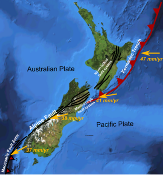
The North Island Fault System (NIFS) is a set of southwest–northeast trending seismically-active faults in the North Island of New Zealand that carry much of the dextral strike-slip component of the oblique convergence of the Pacific Plate with the Australian Plate. However despite at least 3 km (1.9 mi) of uplift of the axial ranges in the middle regions of the fault system during the last 10 million years most of the shortening on this part of the Hikurangi Margin is accommodated by subduction.

<span class="mw-page-title-main">Wairarapa Fault</span> Active seismic fault in New Zealand

The Wairarapa Fault is an active seismic fault in the southern part of the North Island of New Zealand. It is a dextral strike-slip fault with a component of uplift to the northwest as expressed by the Rimutaka Range. It forms part of the North Island Fault System, which accommodates the transfer of displacement along the oblique convergent boundary between the Indo-Australian Plate and Pacific Plate.

<span class="mw-page-title-main">Wellington Fault</span> Active seismic fault in New Zealand

The Wellington Fault is an active seismic fault in the southern part of the North Island of New Zealand. It is a dextral (right-lateral) strike-slip fault with variable amounts of vertical movement causing uplift to the northwest, as expressed by a series of ranges. It forms part of the North Island Fault System, which accommodates the transfer of displacement along the oblique convergent boundary between the Indo-Australian Plate and Pacific Plate.

<span class="mw-page-title-main">June 2011 Christchurch earthquake</span> June 2011 earthquake in New Zealand

The June 2011 Christchurch earthquake was a shallow magnitude 6.0 Mw earthquake that occurred on 13 June 2011 at 14:20 NZST. It was centred at a depth of 7 km (4.3 mi), about 5 km (3 mi) south-east of Christchurch, which had previously been devastated by a magnitude 6.2 MW earthquake in February 2011. The June quake was preceded by a magnitude 5.9 ML tremor that struck the region at a slightly deeper 8.9 km (5.5 mi). The United States Geological Survey reported a magnitude of 6.0 Mw and a depth of 9 km (5.6 mi).

In seismology, an earthquake rupture is the extent of slip that occurs during an earthquake in the Earth's crust. Earthquakes occur for many reasons that include: landslides, movement of magma in a volcano, the formation of a new fault, or, most commonly of all, a slip on an existing fault.

The 2014 Eketāhuna earthquake struck at 3:52 pm on 20 January, centred 15 km east of Eketāhuna in the south-east of New Zealand's North Island. It had a maximum perceived intensity of VII on the Mercalli intensity scale. Originally reported as magnitude 6.6 on the Richter Scale, the earthquake was later downgraded to a magnitude of 6.2. A total of 1112 aftershocks were recorded, ranging between magnitudes 2.0 and 4.9 on the Richter Scale.

The 1934 Pahiatua earthquake struck at 11:46 pm on 5 March, causing severe damage in much of the lower North Island. Wairarapa, Wellington and Hawke's Bay felt the strongest levels of shaking, with much of New Zealand feeling the tremor.

The 1863 Hawke's Bay earthquake was a devastating magnitude 7.5 Mw earthquake that struck near the town of Waipukurau on 23 February 1863. It remained the single largest earthquake to strike Hawke's Bay until 1931, where a magnitude 7.8 quake leveled much of Napier and Hastings, and killed 256 people.

<span class="mw-page-title-main">Kekerengu Fault</span> Active fault in New Zealand

The Kekerengu Fault is an active dextral strike-slip fault in the northeastern part of South Island, New Zealand. It is closely associated with the Hope Fault and Jordan Thrust at its south-easternmost edge and likely joins with the Clarence Fault to form the Wairarapa Fault offshore in Cook Strait.

The Hundalee Fault in northern coastal Canterbury, New Zealand had a significant rupture in the 7.8 Mw 2016 Kaikōura earthquake for a minimal length of 23 km (14 mi) and as such was a key linkage fault in this complex earthquake. It is located between Parnassus in the Hurunui District and runs off shore from near Oaro.

References

  1. 1 2 Khajavi, Narges; Nicol, Andrew; Quigley, Mark C.; Langridge, Robert M. (2018). "Temporal slip-rate stability and variations on the Hope Fault, New Zealand, during the late Quaternary". Tectonophysics. 738–739: 112–123. Bibcode:2018Tectp.738..112K. doi:10.1016/j.tecto.2018.05.001. ISSN   0040-1951. S2CID   135144626.
  2. 1 2 3 4 5 6 7 8 9 10 11 12 13 14 15 16 17 18 19 Berryman, K.; Rattenbury, M.; Bannister, S.; Ellis, S.; Villamor, P.; Eberhart-Phillips, D.O.; Upton, P.; Howell, A. (2023). "Geological structure informs rupture propagation and surface rupture complexity during the 2016 Kaikōura earthquake, New Zealand: insights for future large earthquake hazard". Turkish Journal of Earth Sciences. 32 (3): 330–50. doi: 10.55730/1300-0985.1848 .
  3. 1 2 3 Langridge, R.; Campbell J.; Hill N.; Pere V.; Pope J.; Pettinga J.; Estrada B.; Berryman K. (2003). "Paleoseismology and slip rate of the Conway Segment of the Hope Fault at Greenburn Stream, South Island, New Zealand" (PDF). Annals of Geophysics. 46 (5). Retrieved 27 June 2010.
  4. 1 2 3 4 5 Dolan, J.F.; Van Dissen, R.J.; Rhodes, E.J.; Zinke, R.; Hatem, A.E.; McGuire, C.; Langridge, R.M.; Grenader, J.R. (2024). "One tune, many tempos: Faults trade off slip in time and space to accommodate relative plate motions". Earth and Planetary Science Letters. 625: 118484. doi:10.1016/j.epsl.2023.118484. ISSN   0012-821X.
  5. 1 2 Roberts, A.P. (1995). "Tectonic rotation about the termination of a major strike‐slip fault, Marlborough Fault System, New Zealand". Geophysical Research Letters. 22 (3): 187–190. Bibcode:1995GeoRL..22..187R. doi:10.1029/94GL02582 . Retrieved June 27, 2010.
  6. 1 2 3 4 5 6 7 8 9 Zinke, Robert; Hollingsworth, James; Dolan, James F.; Van Dissen, Russ (2019). "Three-Dimensional Surface Deformation in the 2016 MW 7.8 Kaikōura, New Zealand, Earthquake From Optical Image Correlation: Implications for Strain Localization and Long-Term Evolution of the Pacific-Australian Plate Boundary". Geochemistry, Geophysics, Geosystems. 20 (3): 1609–1628. Bibcode:2019GGG....20.1609Z. doi: 10.1029/2018GC007951 .
  7. Musgrave, R.J. (2003). "Early to Middle Miocene Pacific-Australia plate boundary in New Zealand: an alternative transcurrent-fault system". In Hillis R.R. & Müller R.D. (ed.). Evolution and dynamics of the Australian plate. Geological Society of Australia Special Publications. Vol. 22. Geological Society of America. pp. 333–341. ISBN   978-0-8137-2372-3 . Retrieved 3 July 2010.
  8. 1 2 3 4 Zachariasen, J.; Berryman K.; Langridge R.; Prentice C.; Rymer M.; Striling M.; Villamor P. (2006). "Timing of late Holocene surface rupture of the Wairau Fault, Marlborough, New Zealand". New Zealand Journal of Geology and Geophysics. 49 (1): 159–174. Bibcode:2006NZJGG..49..159Z. doi:10.1080/00288306.2006.9515156. S2CID   131143751.
  9. 1 2 Nicol, A.; Van Dissen R. (2002). "Up-dip partitioning of displacement components on the oblique-slip Clarence Fault, New Zealand". Journal of Structural Geology. 24 (9): 1521–1535. Bibcode:2002JSG....24.1521N. doi:10.1016/S0191-8141(01)00141-9.
  10. 1 2 Mason, D.P.M.; Little T.A.; Van Dissen R.J. (2006). "Rates of active faulting during late Quaternary fluvial terrace formation at Saxton River, Awatere fault, New Zealand". Geological Society of America Bulletin. 118 (11–12): 1431–1446. Bibcode:2006GSAB..118.1431M. doi:10.1130/B25961.1 . Retrieved 27 June 2010.
  11. Lensen, G.J. (2016-11-14). "Note on fault correlations across cook strait". New Zealand Journal of Geology and Geophysics (published 2012-02-09). 1 (2): 263. doi:10.1080/00288306.1958.10423182.
  12. "Huge fault rupture stretches 34km offshore from Kaikoura". Stuff.co.nz: Stuff.co.nz. 23 November 2016. Retrieved 24 November 2016.
  13. 1 2 3 4 5 "New Zealand Active Fault database" . Retrieved 2023-05-13.
  14. Kieckhefer, R. M. (1977). "Microseismicity in the vicinity of the clarence fault, New Zealand". New Zealand Journal of Geology and Geophysics. 20 (1): 165–177. Bibcode:1977NZJGG..20..165K. doi:10.1080/00288306.1977.10431598.