Wairau Fault

Last updated
Wairau Fault
MarlboroughFaultSystem.png
Map of the Marlborough Fault System with Wairau Fault in light purple
Etymology Wairau River
Country New Zealand
Region Marlborough
Characteristics
Rangeup to 7.7 MW [1]
Length200 km (120 mi) [1]
Displacement 3.5 mm (0.14 in)/year [2]
Tectonics
Plate Indo-Australian, Pacific
Status Active
Earthquakes prehistoric
Type Strike-slip fault
Movement Dextral/convergent, east side up
Age Miocene-Holocene
Orogeny Kaikoura
New Zealand geology database (includes faults)
The eastern end of the Wairau Fault reaches the sea at the outlet of the Wairau River in Cloudy Bay in this view from the north east. The hills beyond the fault line that runs along the Wairau River (middle of photo) are the Richmond Range. ISS008-E-6428 - View of the South Island of New Zealand.jpg
The eastern end of the Wairau Fault reaches the sea at the outlet of the Wairau River in Cloudy Bay in this view from the north east. The hills beyond the fault line that runs along the Wairau River (middle of photo) are the Richmond Range.

The Wairau Fault is an active dextral (right lateral) strike-slip fault in the northeastern part of South Island, New Zealand. It forms part of the Marlborough Fault System, which accommodates the transfer of displacement along the oblique convergent boundary between the Indo-Australian Plate and Pacific Plate, from the transform Alpine Fault to the Hikurangi Trench subduction zone. [3]

Contents

Extent

Depending on the precise definition used, the Wairau Fault runs either from southern or northern end of 'The Bends' region. In the former case it is regarded as the Wairau segment of the Alpine Fault which means the Alpine Fault is about 800 km (500 mi) long. [4] In the latter case it is regarded as a separate fault and runs about 200 km (120 mi) [1] from near Lake Rotoiti to the edge of the continental shelf in Cook Strait near Cloudy Bay in the east. [1] To the west, the fault is a single strand but near Wairau Valley township, the fault splits into two strands. These two strands continue to within about 15 km of the coast near Renwick. Further to the east only the southernmost strand can be detected [5] intermittently by lidar [2] and with offshore mapping. [2] It takes its name from the Wairau River, which follows the fault trace for most of its length on land.

Geology

The fault follows a valley where Pleistocene and Holocene deposits have been laid down over bedrock during the last two million years and where the river often obscures recent fault traces. [2] The underlying bedrock which is very rarely exposed along the fault line itself is to the fault's north the Dun Mountain, Maitai and Caples terranest and Triassic and Cretaceous greywacke otherwise. [2] The western fault zone width is about 300 m (980 ft) and contains several fault scarps up to 5 m (16 ft) high. [2]

Relationship to Alpine Fault

As said above, some have regarded it as a segment of the Alpine Fault. This does not concord with the rest of the Alpine Fault having a fairly predictable relatively short recurrence interval for major earthquakes of 291 ± 21 years [6] with good evidence for multi-segment rupture on many of these events over the last 2000 years. [7] The last rupture that may also have involved the Alpine Fault is about 2000 years ago which does not apply to the other active segments of the Alpine Fault (see timeline).

Wairau Fault

It has been stated that "Co-rupture of the Wairau and Alpine faults during great earthquakes occurs rarely (if at all) on millennial or longer timescales." [1]

Recent seismicity

There was an event confined to the coastal and off shore portions of the fault that is poorly constrained in time but is between 970 and 1750 BP, and was about 6 MW. [1] From the offset of dated river terraces a displacement of 23 m (75 ft) has been estimated along the Wairau Fault since about 5610 years BP. Trenching studies along the trace of the Wairau Fault have identified four dateable slip events within this interval, the age of latest event now on redating and further trench work at two other locations falls in the range 1930 to 2110 BP and was about 7.4 MW. [1] The average recurrence interval for surface disrupting earthquakes along the land portion of the fault is about 1000 years. [1] The estimated average slip for each land event is about 6 m (20 ft) [5] and the maximum is 10 m (33 ft). [1] However it is noted that the offshore fault record extends back 18,000 years and this has a longer recurrence interval of 2200 years, possibly because the fault has been more active in the last 6000 years. [1]

Seismic hazard

The recurrence interval of slip events estimated for the fault combined with the estimated time since the last event suggest "that the Wairau Fault is nearing the end of its interseismic period". [5] The current estimated seismic hazard from the Wairau Fault is considered to be relatively high with a current slip rate of up to 3.5 mm (0.14 in)/year to accommodate. [1] The magnitude of such an earthquake could be up to 7.7 MW. [1] The fault runs alongside State Highway 63 to its end at the township of Renwick and presumably with full rupture would be disruptive to the town of Blenheim which is within 5 km (3.1 mi) of the fault and the port facilities of Picton less than 20 km (12 mi) away. [2]

Related Research Articles

<span class="mw-page-title-main">Alpine Fault</span> Right-lateral strike-slip fault, that runs almost the entire length of New Zealands South Island.

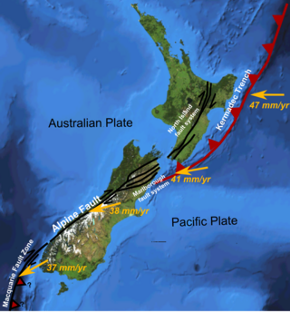
The Alpine Fault is a geological fault that runs almost the entire length of New Zealand's South Island, being about 600 km (370 mi). long, and forms the boundary between the Pacific Plate and the Australian Plate. The Southern Alps have been uplifted on the fault over the last 12 million years in a series of earthquakes. However, most of the motion on the fault is strike-slip, with the Tasman district and West Coast moving north and Canterbury and Otago moving south. The average slip rates in the fault's central region are about 38 mm (1.5 in) a year, very fast by global standards. The last major earthquake on the Alpine Fault was in about 1717 AD with a great earthquake magnitude of Mw8.1. The probability of another one occurring within the next 50 years is estimated at 75 percent.

<span class="mw-page-title-main">Hope Fault</span> Active fault in New Zealand

The Hope Fault is an active dextral strike-slip fault in the northeastern part of South Island, New Zealand. It forms part of the Marlborough Fault System, which accommodates the transfer of displacement along the oblique convergent boundary between the Indo-Australian Plate and Pacific Plate, from the transform Alpine Fault to the Hikurangi Trench subduction zone.

The 1855 Wairarapa earthquake occurred on 23 January at about 9.17 p.m., affecting much of the Cook Strait area of New Zealand, including Marlborough in the South Island and Wellington and the Wairarapa in the North Island. In Wellington, close to the epicentre, shaking lasted for at least 50 seconds. The moment magnitude of the earthquake has been estimated as 8.2, the most powerful recorded in New Zealand since systematic European colonisation began in 1840. This earthquake was associated with the largest directly observed movement on a strike-slip fault, maximum 18 metres (59 ft). This was later revised upward to about 20 m (66 ft) slip, with a local peak of 8 m (26 ft) vertical displacement on lidar studies. It has been suggested that the surface rupture formed by this event helped influence Charles Lyell to link earthquakes with rapid movement on faults.

<span class="mw-page-title-main">Marlborough fault system</span> Active fault system in New Zealand

The Marlborough fault system is a set of four large dextral strike-slip faults and other related structures in the northern part of South Island, New Zealand, which transfer displacement between the mainly transform plate boundary of the Alpine fault and the mainly destructive boundary of the Kermadec Trench, and together form the boundary between the Australian and Pacific Plates.

<span class="mw-page-title-main">Awatere Fault</span>

The Awatere Fault is an active dextral strike-slip fault in the northeastern part of South Island, New Zealand. It forms part of the Marlborough Fault System, which accommodates the transfer of displacement along the oblique convergent boundary between the Indo-Australian Plate and Pacific Plate, from the transform Alpine Fault to the Hikurangi Trench subduction zone. The 1848 Marlborough earthquake was caused by rupture of the whole of the eastern section of the Awatere Fault.

<span class="mw-page-title-main">Clarence Fault</span> Active fault in New Zealand

The Clarence Fault is an active dextral strike-slip fault in the northeastern part of South Island, New Zealand. It forms part of the Marlborough Fault System, which accommodates the transfer of displacement along the oblique convergent boundary between the Indo-Australian Plate and Pacific Plate, from the transform Alpine Fault to the Hikurangi Trench subduction zone.

<span class="mw-page-title-main">North Island Fault System</span> Fault zone of the east coast of New Zealands North Island

The North Island Fault System (NIFS) is a set of southwest–northeast trending seismically-active faults in the North Island of New Zealand that carry much of the dextral strike-slip component of the oblique convergence of the Pacific Plate with the Australian Plate. However despite at least 3 km (1.9 mi) of uplift of the axial ranges in the middle regions of the fault system during the last 10 million years most of the shortening on this part of the Hikurangi Margin is accommodated by subduction.

<span class="mw-page-title-main">Wairarapa Fault</span> Active seismic fault in New Zealand

The Wairarapa Fault is an active seismic fault in the southern part of the North Island of New Zealand. It is a dextral strike-slip fault with a component of uplift to the northwest as expressed by the Rimutaka Range. It forms part of the North Island Fault System, which accommodates the transfer of displacement along the oblique convergent boundary between the Indo-Australian Plate and Pacific Plate.

<span class="mw-page-title-main">Wellington Fault</span> Active seismic fault in New Zealand

The Wellington Fault is an active seismic fault in the southern part of the North Island of New Zealand. It is a dextral (right-lateral) strike-slip fault with variable amounts of vertical movement causing uplift to the northwest, as expressed by a series of ranges. It forms part of the North Island Fault System, which accommodates the transfer of displacement along the oblique convergent boundary between the Indo-Australian Plate and Pacific Plate.

The 1934 Pahiatua earthquake struck at 11:46 pm on 5 March, causing severe damage in much of the lower North Island. Wairarapa, Wellington and Hawke's Bay felt the strongest levels of shaking, with much of New Zealand feeling the tremor.

<span class="mw-page-title-main">Kekerengu Fault</span> Active fault in New Zealand

The Kekerengu Fault is an active dextral strike-slip fault in the northeastern part of South Island, New Zealand. It is closely associated with the Hope Fault and Jordan Thrust at its south-easternmost edge and likely joins with the Clarence Fault to form the Wairarapa Fault offshore in Cook Strait.

<span class="mw-page-title-main">Paeroa Fault</span> Active fault in New Zealand

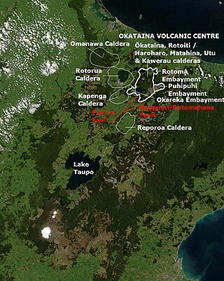
The Paeroa Fault is a seismically active area in the Taupō District, Waikato Region of the central North Island of New Zealand.

<span class="mw-page-title-main">Taupō Rift</span> A continental rift valley in New Zealand

The Taupō Rift is the seismically active rift valley containing the Taupō Volcanic Zone, central North Island of New Zealand.

<span class="mw-page-title-main">Ngapouri-Rotomahana Fault</span>

The Ngapouri-Rotomahana Fault is a seismically and volcanically active area of the central North Island of New Zealand.

The Taupō Fault Belt contains many almost parallel active faults, and is located in the Taupō Rift of the central North Island of New Zealand geographically between Lake Taupō and the lakes of Rotorua, Tarawera, Rotomahana and Rerewhakaaitu. The potential active fault density is very high, with only 0.1 to 1 km separating the north-east to south-west orientated normal fault strands on detailed mapping of part of the belt. The Waikato River bisects the western region of the belt.

The seismically active southern end of the Taupō Rift beyond Mount Ruapehu has a number of mainly east to west orientated termination faults where the western wall Raurimu Fault and eastern wall Rangipo Fault terminate in the Ruapehu Graben, of the central North Island of New Zealand. In a multi-fault rupture event there is the potential for the earthquake being of Mw7.1 magnitude.

The Rangipo Fault is the eastern Taupō rift-bounding north–south striking normal fault complex of the Ruapehu Graben, a seismically active area of the central North Island of New Zealand to the west of Mount Ruapehu. It could be part of a Mw7.1 potential rupture.

The Upper Waikato Stream Fault is an eastern Taupō rift-bounding north–south striking normal fault in the Ruapehu Graben, a seismically active area of the central North Island of New Zealand to the west of Mount Ruapehu. While its own whole fault rupture potential is Mw6.5, such a rupture could be part of a Mw 7.1 multi-fault rupture.

<span class="mw-page-title-main">Ostler Fault Zone</span> Fault zone in New Zealand

The Ostler Fault Zone is an active fault zone, to the east of the Alpine Fault in South Canterbury, South Island of New Zealand. It has had multiple recent rupture events greater than ML6.5 in magnitude, with a recent 6.9 to 7.0 event, and has recently accommodated 1.9 mm (0.075 in)/year of compression and thus land contraction.

The Hundalee Fault in northern coastal Canterbury, New Zealand had a significant rupture in the 7.8 Mw 2016 Kaikōura earthquake for a minimal length of 23 km (14 mi) and as such was a key linkage fault in this complex earthquake. It is located between Parnassus in the Hurunui District and runs off shore from near Oaro.

References

  1. 1 2 3 4 5 6 7 8 9 10 11 12 Nicol, Andrew; Van Dissen, Russ (2018). "A 6000-year record of surface-rupturing paleoearthquakes on the Wairau Fault, New Zealand". New Zealand Journal of Geology and Geophysics. 61 (3): 341–358. doi:10.1080/00288306.2018.1498360. S2CID   135174507.
  2. 1 2 3 4 5 6 7 Langridge, R.M.; Ries, W.F. (2016). "Active Fault Mapping and Fault Avoidance Zones for the Wairau Fault, Marlborough District GNS Science Consultancy Report 2016/25" (PDF). Retrieved 2023-05-10.
  3. Langridge, R.; Campbell J.; Hill N.; Pere V.; Pope J.; Pettinga J.; Estrada B.; Berryman K. (2003). "Paleoseismology and slip rate of the Conway Segment of the Hope Fault at Greenburn Stream, South Island, New Zealand" (PDF). Annals of Geophysics. 46 (5). Retrieved 27 June 2010.
  4. Berryman, K.; Cooper, A.F.; Norris, R.J.; Villamor, P.; Sutherland, R.; Wright, T.; Schermer, E.R.; Langridge, R.; Biasi, G. (2012). "Late Holocene Rupture History of the Alpine Fault in South Westland, New Zealand". Bulletin of the Seismological Society of America. 102 (2): 620–638. Bibcode:2012BuSSA.102..620B. doi:10.1785/0120110177.
  5. 1 2 3 Zachariasen, J.; Berryman K.; Langridge R.; Prentice C.; Rymer M.; Striling M.; Villamor P. (2006). "Timing of late Holocene surface rupture of the Wairau Fault, Marlborough, New Zealand". New Zealand Journal of Geology and Geophysics. 49 (1): 159–174. doi:10.1080/00288306.2006.9515156.
  6. Cochran, U.A.; Clark, K.J.; Howarth, J.D.; Biasi, G.P.; Langridge, R.M.; Villamor, P.; Berryman, K.R.; Vandergoes, M.J. (2017). "A plate boundary earthquake record from a wetland adjacent to the Alpine fault in New Zealand refines hazard estimates". Earth and Planetary Science Letters. 464: 175–188. Bibcode:2017E&PSL.464..175C. doi:10.1016/j.epsl.2017.02.026. ISSN   0012-821X.
  7. Howarth, Jamie D.; Cochran, Ursula A.; Langridge, Robert M.; Clark, Kate; Fitzsimons, Sean J.; Berryman, Kelvin; Villamor, Pilar; Strong, Delia T. (2018). "Past large earthquakes on the Alpine Fault: paleoseismological progress and future directions". New Zealand Journal of Geology and Geophysics. 61 (3): 309–328. doi:10.1080/00288306.2018.1464658. S2CID   134211005.