
The Clarence River is a major river which flows through the Kaikōura Ranges in the northeast of New Zealand's South Island. At roughly 209 kilometres (130 mi) long, it is the longest river in Canterbury and the eighth longest in New Zealand.

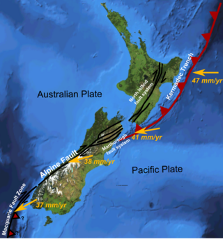
The Alpine Fault is a geological fault that runs almost the entire length of New Zealand's South Island, being about 600 km (370 mi). long, and forms the boundary between the Pacific plate and the Australian plate. The Southern Alps have been uplifted on the fault over the last 12 million years in a series of earthquakes. However, most of the motion on the fault is strike-slip, with the Tasman district and West Coast moving north and Canterbury and Otago moving south. The average slip rates in the fault's central region are about 38 mm (1.5 in) a year, very fast by global standards. The last major earthquake on the Alpine Fault was in about 1717 AD with a great earthquake magnitude of 8.1± 0.1. The probability of another one occurring before 2068 was estimated at 75 percent in 2021.
Strike-slip tectonics or wrench tectonics is a type of tectonics that is dominated by lateral (horizontal) movements within the Earth's crust. Where a zone of strike-slip tectonics forms the boundary between two tectonic plates, this is known as a transform or conservative plate boundary. Areas of strike-slip tectonics are characterised by particular deformation styles including: stepovers, Riedel shears, flower structures and strike-slip duplexes. Where the displacement along a zone of strike-slip deviates from parallelism with the zone itself, the style becomes either transpressional or transtensional depending on the sense of deviation. Strike-slip tectonics is characteristic of several geological environments, including oceanic and continental transform faults, zones of oblique collision and the deforming foreland of zones of continental collision.
The 1888 North Canterbury earthquake occurred at 4:10 am on 1 September following a sequence of foreshocks that started the previous evening, and whose epicentre was in the North Canterbury region of the South Island of New Zealand. The epicentre was approximately 35 kilometres (22 mi) west of Hanmer.
The 1855 Wairarapa earthquake occurred on 23 January at about 9.17 p.m., affecting much of the Cook Strait area of New Zealand, including Marlborough in the South Island and Wellington and the Wairarapa in the North Island. In Wellington, close to the epicentre, shaking lasted for at least 50 seconds. The moment magnitude of the earthquake has been estimated as 8.2, the most powerful recorded in New Zealand since systematic European colonisation began in 1840. This earthquake was associated with the largest directly observed movement on a strike-slip fault, maximum 18 metres (59 ft). This was later revised upward to about 20 m (66 ft) slip, with a local peak of 8 m (26 ft) vertical displacement on lidar studies. It has been suggested that the surface rupture formed by this event helped influence Charles Lyell to link earthquakes with rapid movement on faults.
The 1848 Marlborough earthquake was a 7.5 earthquake that occurred at 1:40 a.m. on 16 October 1848 and whose epicentre was in the Marlborough region of the South Island of New Zealand.
The 1843 Whanganui earthquake occurred on 8 July at 16:45 local time with an estimated magnitude of 7.5 on the scale. The maximum perceived intensity was IX (Violent) on the Mercalli intensity scale, and possibly reaching X (Extreme). The epicentre is estimated to have been within a zone extending 50 km northeast from Whanganui towards Taihape. GNS Science has this earthquake catalogued and places the epicentre 35 km east of Taihape, near the border of Hawke's Bay. This was the first earthquake in New Zealand over magnitude 7 for which written records exist, and the first for which deaths were recorded.
The 1929 Arthur's Pass earthquake occurred at on 9 March. The sparsely settled region around Arthur's Pass of the Southern Alps shook for four minutes. Tremors continued almost continuously until midnight and sporadic strong aftershocks were felt for several days.

The Marlborough fault system is a set of four large dextral strike-slip faults and other related structures in the northern part of the South Island, New Zealand, which transfer displacement between the mainly transform plate boundary of the Alpine fault and the mainly destructive boundary of the Kermadec Trench, and together form the boundary between the Australian and Pacific Plates.
The Wairau Fault is an active dextral strike-slip fault in the northeastern part of South Island, New Zealand. It forms part of the Marlborough Fault System, which accommodates the transfer of displacement along the oblique convergent boundary between the Indo-Australian Plate and Pacific Plate, from the transform Alpine Fault to the Hikurangi Trough subduction zone.
The Awatere Fault is an active dextral strike-slip fault in the northeastern part of South Island, New Zealand. It forms part of the Marlborough fault system, which accommodates the transfer of displacement along the oblique convergent boundary between the Indo-Australian plate and Pacific plate, from the transform Alpine Fault to the Hikurangi Trough subduction zone. The 1848 Marlborough earthquake was caused by rupture of the whole of the eastern section of the Awatere Fault. The 175 km (109 mi) long Awatere Fault is formed of two main segments; the Molesworth section to the southwest and the Eastern section to the northeast. A further strand links the southwestern end of the Eastern section to the Clarence Fault, passing through Barefell Pass.
The Clarence Fault is an active dextral strike-slip fault in the northeastern part of South Island, New Zealand. It forms part of the Marlborough fault system, which accommodates the transfer of displacement along the oblique convergent boundary between the Indo-Australian plate and Pacific plate, from the transform Alpine Fault to the Hikurangi Trough subduction zone.
The North Island Fault System (NIFS) is a set of southwest–northeast trending seismically-active faults in the North Island of New Zealand that carry much of the dextral strike-slip component of the oblique convergence of the Pacific Plate with the Australian Plate. However despite at least 3 km (1.9 mi) of uplift of the axial ranges in the middle regions of the fault system during the last 10 million years most of the shortening on this part of the Hikurangi Margin is accommodated by subduction.

The Wairarapa Fault is an active seismic fault in the southern part of the North Island of New Zealand. It is a dextral strike-slip fault with a component of uplift to the northwest as expressed by the Rimutaka Range. It forms part of the North Island Fault System, which accommodates the transfer of displacement along the oblique convergent boundary between the Indo-Australian Plate and Pacific Plate.

The Wellington Fault is an active seismic fault in the southern part of the North Island of New Zealand. It is a dextral (right-lateral) strike-slip fault with variable amounts of vertical movement causing uplift to the northwest, as expressed by a series of ranges. It forms part of the North Island Fault System, which accommodates the transfer of displacement along the oblique convergent boundary between the Indo-Australian Plate and Pacific Plate.

The Kekerengu Fault is an active dextral strike-slip fault in the northeastern part of South Island, New Zealand. It is closely associated with the Hope Fault and Jordan Thrust at its south-easternmost edge and likely joins with the Clarence Fault to form the Wairarapa Fault offshore in Cook Strait.
The Buesaco-Aranda Fault is a dextral strike-slip fault in the department of Nariño in southwestern Colombia. The fault has a total length of 29 kilometres (18 mi) and runs along an average northeast to southwest strike in the Central Ranges of the Colombian Andes. The 1995 Pasto earthquake is associated with the active fault showing high amounts of displacement. The earthquake caused seven fatalities.

The Kyaukkyan Fault Zone is a large complex strike-slip fault that extends for about 510 km from Shan state, Myanmar to Thailand. It was the source of the 1912 Shan state earthquake when it ruptured for a length of 160 km along the northernmost segment. The fault is not very well studied, unlike the Sagaing Fault. The fault runs through the Shan hills nearly parallel to the Sagaing Fault. It is highly segmented, characterized by a broad array of splaying segments and basins, dominated by releasing bends and associated extensional fault systems. The slip rate for this fault is about 1 mm/yr.
The Kaikōura Canyon is a geologically active submarine canyon located southwest of the Kaikōura Peninsula off the northeastern coast of the South Island of New Zealand. It is 60 kilometres (37 mi) long, and is generally U-shaped. The canyon descends into deep water and merges into an ocean channel system that can be traced for hundreds of kilometres across the deep ocean floor. At the head of the Kaikōura Canyon, the depth of water is around 30 metres (98 ft), but it drops rapidly to 600 metres (2,000 ft) and continues down to around 2,000 metres (6,600 ft) deep where it meets the Hikurangi Channel. Sperm whales can be seen close to the coast south of Goose Bay, because the deep water of the Kaikōura Canyon is only one kilometre (0.62 mi) off the shoreline in this area.
The Hundalee Fault in northern coastal Canterbury, New Zealand had a significant rupture in the 7.8 2016 Kaikōura earthquake for a minimal length of 23 km (14 mi) and as such was a key linkage fault in this complex earthquake. It is located between Parnassus in the Hurunui District and runs off shore from near Oaro.


