Related Research Articles
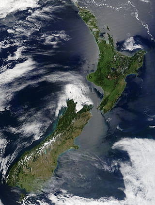
New Zealand is an island country located in the southwestern Pacific Ocean, near the centre of the water hemisphere. It consists of a large number of islands, estimated around 700, mainly remnants of a larger landmass now beneath the sea. The land masses by size are the South Island and the North Island, separated by the Cook Strait. The third-largest is Stewart Island / Rakiura, located 30 kilometres off the tip of the South Island across Foveaux Strait. Other islands are significantly smaller in area. The three largest islands stretch 1,600 kilometres across latitudes 35° to 47° south. New Zealand is the sixth-largest island country in the world, with a land size of 268,680 km2 (103,740 sq mi).

Canterbury is a region of New Zealand, located in the central-eastern South Island. The region covers an area of 44,503.88 square kilometres (17,183.04 sq mi), making it the largest region in the country by area. It is home to a population of 694,400.

Christchurch is the largest city in the South Island and the second-largest city by urban area population in New Zealand. Christchurch has an urban population of 415,100, and a metropolitan population of over half a million. It is located in the Canterbury Region, near the centre of the east coast of the South Island, east of the Canterbury Plains. It is located near the southern end of Pegasus Bay, and is bounded to the east by the Pacific Ocean and to the south by the ancient volcanic complex of the Banks Peninsula. The Avon River (Ōtākoro) winds through the centre of the city, with a large urban park along its banks. With the exception of the Port Hills, it is a relatively flat city, on an average around 20 m (66 ft) above sea level. Christchurch has a reputation for being an English city, with its architectural identity and nickname the 'Garden City' due to similarities with garden cities in England, but also has a historic Māori heritage. Christchurch has a temperate oceanic climate with regular moderate rainfall.
Edgecumbe is a town in the Bay of Plenty Region of the North Island of New Zealand, 15 kilometres (9.3 mi) to the west of Whakatāne and 8 kilometres (5.0 mi) south of the Bay's coast.

Cashmere is a suburb which rises above the southern end of the city of Christchurch in New Zealand's South Island, on the north side of the Port Hills. It covers an area of 4.71 km2 (1.82 sq mi) and has a population of 6,453 as at 2018.

The 1987 Edgecumbe earthquake measured 6.5 on the moment magnitude scale and struck the Bay of Plenty region of New Zealand at 1.42 pm on 2 March. The hypocentre was at a shallow depth of 8 km. The epicentre was 2.24 kilometres (1.39 mi) south-south-east of the town of Matata, and 15 kilometres (9.3 mi) north-north-west of Edgecumbe, on the Rangitaiki Plains. It was the most damaging earthquake New Zealand had experienced since the 1968 Inangahua earthquake.

The Aleutian Trench is an oceanic trench along a convergent plate boundary which runs along the southern coastline of Alaska and the Aleutian islands. The trench extends for 3,400 kilometres (2,100 mi) from a triple junction in the west with the Ulakhan Fault and the northern end of the Kuril–Kamchatka Trench, to a junction with the northern end of the Queen Charlotte Fault system in the east. It is classified as a "marginal trench" in the east as it runs along the margin of the continent. The subduction along the trench gives rise to the Aleutian Arc, a volcanic island arc, where it runs through the open sea west of the Alaska Peninsula. As a convergent plate boundary, the trench forms part of the boundary between two tectonic plates. Here, the Pacific plate is being subducted under the North American plate at a dip angle of nearly 45°. The rate of closure is 7.5 centimetres (3 in) per year.

The 2007 Gisborne earthquake occurred under the Pacific Ocean about 50 kilometres (31 mi) off the eastern coast of New Zealand's North Island at 8:55 pm NZDT on 20 December. With a moment magnitude of 6.7 and maximum Mercalli intensity of VII, the tremor affected the city of Gisborne and was felt widely throughout the country, from Auckland in the north to Dunedin in the south.
The 1888 North Canterbury earthquake occurred at 4:10 am on 1 September following a sequence of foreshocks that started the previous evening, and whose epicentre was in the North Canterbury region of the South Island of New Zealand. The epicentre was approximately 35 kilometres (22 mi) west of Hanmer.
The 2009 Swan Islands earthquake occurred on May 28 at 02:24:45 AM local time with a moment magnitude of 7.3 and a maximum Mercalli intensity of VII. The epicenter was located in the Caribbean Sea, 64 kilometres (40 mi) northeast of the island of Roatán, 19 miles northeast of Port Royal, Isla de Bahias, 15 miles northwest of Isla Barbaretta, and 130 kilometres (81 mi) north-northeast of La Ceiba. Three aftershocks followed the earthquake within magnitude 4 range.

The 2009 Dusky Sound earthquake was a Mw 7.8 earthquake that struck a remote region of Fiordland, New Zealand, on 15 July at 21:22 local time. It had an initially–reported depth of 12 km (7.5 mi), and an epicentre near Dusky Sound in Fiordland National Park, which is 160 km (99 mi) north-west of Invercargill. It was the country's largest earthquake magnitude since the 1931 Hawke's Bay earthquake, but caused only minor damage and there were no casualties. A tsunami accompanied the event and had a maximum measured run-up of 230 cm (91 in).
The 2010 Canterbury earthquake struck the South Island of New Zealand with a moment magnitude of 7.1 at 4:35 am local time on 4 September, and had a maximum perceived intensity of X (Extreme) on the Mercalli intensity scale. Some damaging aftershocks followed the main event, the strongest of which was a magnitude 6.3 shock known as the Christchurch earthquake that occurred nearly six months later on 22 February 2011. Because this aftershock was centred very close to Christchurch, it was much more destructive and resulted in the deaths of 185 people.
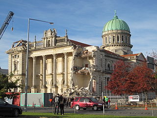
A major earthquake occurred in Christchurch on Tuesday 22 February 2011 at 12:51 p.m. local time. The Mw6.2 earthquake struck the Canterbury region in the South Island, centred 6.7 kilometres (4.2 mi) south-east of the central business district. It caused widespread damage across Christchurch, killing 185 people in New Zealand's fifth-deadliest disaster. Scientists classified it as an intraplate earthquake and potentially an aftershock of the 2010 Canterbury earthquake.

The June 2011 Christchurch earthquake was a shallow magnitude 6.0 Mw earthquake that occurred on 13 June 2011 at 14:20 NZST. It was centred at a depth of 7 km (4.3 mi), about 5 km (3 mi) south-east of Christchurch, which had previously been devastated by a magnitude 6.2 MW earthquake in February 2011. The June quake was preceded by a magnitude 5.9 ML tremor that struck the region at a slightly deeper 8.9 km (5.5 mi). The United States Geological Survey reported a magnitude of 6.0 Mw and a depth of 9 km (5.6 mi).
The 2013 Seddon earthquake measured 6.5 on the Mww scale and was centred in New Zealand's Cook Strait, around 20 kilometres (12 mi) east of the town of Seddon in Marlborough. The earthquake struck at 5:09 pm on Sunday 21 July 2013 at a depth of 13 kilometres (8 mi), according to GeoNet. The United States Geological Survey also measured the quake at 6.5, at a depth of 17 kilometres (11 mi). The quake caused moderate damage in the wider Marlborough area and Wellington, the nation's capital city 55 kilometres (34 mi) north of the epicentre. Only minor injuries were reported. Several aftershocks occurred during 21–29 July.

The 2016 Kaikōura earthquake was a Mw 7.8 earthquake in the South Island of New Zealand that occurred two minutes after midnight on 14 November 2016 NZDT. Ruptures occurred on multiple faults and the earthquake has been described as the "most complex earthquake ever studied". It has been subsequently modelled as having a megathrust component set off by an adjacent rupture on the Humps Fault. It was the second largest earthquake in New Zealand since European settlement.

The Canterbury Earthquake Recovery Act 2011 was a New Zealand statute that repealed the Canterbury Earthquake Response and Recovery Act 2010 and set out measures to respond to the impact of the Canterbury earthquakes, and in particular the February 2011 Christchurch earthquake.
The 2003 Fiordland earthquake struck the remote region of Fiordland in the South Island of New Zealand on 22 August 2003, at 12:12 am NZST. The epicentre was 12 kilometres (7.5 mi) deep, and was thought to be near Secretary Island at the entrance to Doubtful Sound. At 7.2 Ms magnitude, it was one of the largest quakes in the country for some time, and was the largest shallow quake since the 1968 Inangahua earthquake. There was an aftershock two hours later at 2:12 am, followed over several days by frequent small tremors; two months after the earthquake, there had been 8,000 aftershocks.
In 1914, two earthquakes shook the upper North Island of New Zealand, on Wednesday 7 October and Wednesday 28 October. They were large and shallow, with their epicentres close together northwest of Ruatoria in the Gisborne District. The earthquakes were felt strongly throughout the East Cape area, most noticeably in areas east of the epicentre such as Waipiro Bay, with a large amount of damage occurring in Tokomaru Bay in particular. One person was killed by a landslide near Cape Runaway.
References
- 1 2 3 "New Zealand Earthquake Report – 22 February 2011 at 12:51 pm (NZDT)". GeoNeturl=http://www.geonet.org.nz/earthquake/quakes/3468575g.html. 22 February 2011. Archived from the original on 23 February 2011.
- ↑ M6.3 – South Island of New Zealand Archived 6 September 2013 at the Wayback Machine , USGS