Otago fault system

Last updated
Otago fault system
Otago reverse fault province
Otago Map Physical New Zealand.jpg
The physical land features of Otago, in particular the orientation of the main mountain or hill ranges are related to the orentation of the Otago fault system.
Otago fault system
Map of approximate active surface faults (red) and potentially active faults and fault zones (pink shading) associated with Otago fault system. The Alpine Fault is also shown. Click on the map to enable mouse over of fault features.'"`UNIQ--ref-00000000-QINU`"'
Etymology Otago
Year defined2000
Country New Zealand
Region Otago Region
Characteristics
Range Mw 7+ [1] [2]
Segmentsmany
Length100 km (62 mi) [2]
Tectonics
Plate Indo-Australian
Status Active
Type Multiple but mainly reverse
Age Miocene-Holocene
Volcanic arc/belt Dunedin volcanic group
New Zealand geology database (includes faults)

The Otago fault system (also known as Otago reverse fault province) contains multiple faults with the potential to have rupture events greater than Mw 7 in magnitude. [1] [2] These are parallel to, and to the east of the Alpine Fault in the south eastern part of the South Island of New Zealand. It accommodates about 2 mm (0.079 in)/year of contraction. [1]

Contents

Geography

East of the Southern Alps, Central Otago has a number of parallel, northeast trending ranges separating broad, flat-bottomed valleys which extend to the coast of Otago. These ranges are associated with the main reverse faults of the system. [1] Near the Southern Alps the faults with this north-east trend continue through Lindis Pass into South Canterbury and so the Dalrachney/Lindis Pass Fault and the Ostler Fault Zone in South Canterbury are geologically related to the Otago fault system. [3] Otago, towards the coast, is separated from South Canterbury by the Waitaki River and the south western aspect of this river valley is defined by mainly normal north-northwest striking faults such as the Hawkdun Fault, and Waihemo fault zone. [3] The south eastern part of the zone is limited by Fiordland and the Hillfoot Fault in Southland which is a reverse fault [4] on the Otago side of the Hokonui Hills and The Catlins. Just off the coast from Dunedin towards the south are several active northeast-trending faults of the system. [1]

Geology

Tectonics

The boundary between the Australian and Pacific plates passes through the west of the South Island of New Zealand, as the very active by world standards, Alpine Fault. While this takes up a major part of the movement across these plate boundaries, a fifth of the currently 10 mm (0.39 in) /year compression element is taken up by the Otago fault system in mainly the Permian Ophiolite Belt and Otago schists in the Otago range and basin province. This Otago peneplain lies between the Southland Syncline and the Canterbury Plains. [1] The consequence appears to be long periods of inactivity on individual reverse faults, perhaps 100,000 years and then multiple release events over a few thousand years before moving on to another fault system. [5] Such episodic earthquake activity is thought to be the result of strain sharing between faults within the system. [6] There is now good evidence for this. [7]

Activity

The most recent active faults moving from the north east towards the south are the Ostler Fault Zone and Lewis Pass faults, although these are mainly in Canterbury, the NW Cardrona Fault (and its northern continuation of the Hunter Valley Fault and southern continuation as the Nevis and West Nokomai faults. [3] [2] At the coast the Settlement Fault (essentially in Southland but part of the Otago fault system) and Akatore Fault are the most recently active. The expectation over the whole fault system is a rupture every 100 to 200 years of an earthquake between magnitude 6.5 to 7. [1] Because of the good evidence that some of the faults in the system can have large periods of quiescence, [5] the information that follows should be supplemented by drill down on the map on this page or referral to original references as not all faults that may be significant can be mentioned.

Definitely active faults, in last 10,000 years of the Otago fault system
NameSurface lengthMaximum Slip rateReoccurrenceNotes
Akatore Fault37 km (23 mi)6 mm (0.24 in)/year1700 years [4]
Dunstan Fault Zone63 km (39 mi)0.16 mm (0.0063 in)/year7000 years [7] [3]
Gimmerburn Fault Zone42 km (26 mi)0.4 mm (0.016 in)/year7400 years [3]
Highland Fault12 km (7.5 mi)0.32 mm (0.013 in)/year6500 years [3]
Lindis Pass Fault Zone38 km (24 mi)0.47 mm (0.019 in)/year5600 years [3]
Livingstone Fault6.5 km (4.0 mi)1 mm (0.039 in)/year6400 years [3]
Long Valley Fault13 km (8.1 mi)0.18 mm (0.0071 in)/year7900 years [3]
Motatapu Fault30 km (19 mi)0.32 mm (0.013 in)/year6500 years [3]
Nevis Fault Zone52 km (32 mi)0.4 mm (0.016 in)/year9000 years [3]
NW Cardrona Fault30 km (19 mi)0.38 mm (0.015 in)/year5500 years [3]
Settlement Fault23 km (14 mi)0.79 mm (0.031 in)/year1800 years [4]
Timaru Creek Fault13 km (8.1 mi)0.32 mm (0.013 in)/year6100 years [3]

Akatore Fault

The Akatore Fault is of potential significance as it is the most active fault close to the city of Dunedin and full rupture would be associated with coastal tsunami risk. There have been two ruptures within the last 1300 years. [4] It is unknown if the offshore Green Island Fault is related. [4] If it is, the potential for significant human and property hazard from a whole fault rupture is considerably increased. The onland 23 km (14 mi) fault has at least a 5 km (3.1 mi) offshore extension to the south, and a 9 km (5.6 mi) offshore extension towards Dunedin's coastal suburbs. [4] One recent rupture caused 7.4 m (24 ft) of slip. [4] Before recent activity in the last 15,000 years it had been quiescent for over 100,000 years. The recent activity implies an slip rate of 6 mm (0.24 in)/year with recurrence average of 1700 years. [4] The fault is named for the Akatore Creek, a small stream which flows to the Pacific south of Taieri Mouth.

Titri Fault

The Titri Fault (also known as Titri fault system or Titri fault zone) passes through the western suburbs of Dunedin, often along the course of the railway line south, and is associated with the coastal hills to its east and the Titri anticline. [4] Some[ who? ] believe it may extend all the way to the Water of Leith. [4] It was originally a normal fault with displacement to the southeast over 100 million years ago. [4] It was reactivated perhaps 40,000 years ago with reversal of movement which has formed the coastal hills in the typical northeast orientation of the Otago fault system. The last partial rupture was about 18,000 years ago and single event displacements are about 3.5 m (11 ft). [4] The recent activity implies an slip rate of 0.15 mm (0.0059 in)/year with recurrence average of 19,000 years. [4] The fault is named for the rural locality of Titri, close to the eastern shore of Lake Waihola.

Kaikorai Fault

The Kaikorai Fault is well mapped through the western suburbs of Dunedin and some[ who? ] have considered it a splay of the Titri Fault. If defined as a separate fault it has not been active for at least 20,000 years. It is 16 km (9.9 mi) long and has a long term slip rate of 0.05 mm (0.0020 in)/year and a reoccurrence interval of about 22,000 years. [4] The valley of the Kaikorai Stream runs along the fault.

Hyde Fault

A typical fault induced ridge in Central Otago - in this case the Rock and Pillar Range Maniototo.jpg
A typical fault induced ridge in Central Otago - in this case the Rock and Pillar Range

The 55 km (34 mi) long [6] Hyde Fault is close to the small towns of Hyde and Middlemarch. The last four surface-rupturing earthquakes occurred about 47,000 years ago, 39,000 years ago, 23,000 years ago and 10,300 years ago. [7] Movement along it has built up the Rock and Pillar Range to 1,200 m (3,900 ft) above the valley floor. Its current slip rate has been recently updated to be 0.24 mm (0.0094 in)/year. [7]

Related Research Articles

<span class="mw-page-title-main">Alpine Fault</span> Right-lateral strike-slip fault, that runs almost the entire length of New Zealands South Island.

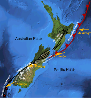
The Alpine Fault is a geological fault that runs almost the entire length of New Zealand's South Island, being about 600 km (370 mi). long, and forms the boundary between the Pacific Plate and the Australian Plate. The Southern Alps have been uplifted on the fault over the last 12 million years in a series of earthquakes. However, most of the motion on the fault is strike-slip, with the Tasman district and West Coast moving north and Canterbury and Otago moving south. The average slip rates in the fault's central region are about 38 mm (1.5 in) a year, very fast by global standards. The last major earthquake on the Alpine Fault was in about 1717 AD with a great earthquake magnitude of Mw8.1. The probability of another one occurring within the next 50 years is estimated at 75 percent.

<span class="mw-page-title-main">Hope Fault</span> Active fault in New Zealand

The Hope Fault is an active dextral strike-slip fault in the northeastern part of South Island, New Zealand. It forms part of the Marlborough Fault System, which accommodates the transfer of displacement along the oblique convergent boundary between the Indo-Australian Plate and Pacific Plate, from the transform Alpine Fault to the Hikurangi Trench subduction zone.

The 1888 North Canterbury earthquake occurred at 4:10 am on 1 September following a sequence of foreshocks that started the previous evening, and whose epicentre was in the North Canterbury region of the South Island of New Zealand. The epicentre was approximately 35 kilometres (22 mi) west of Hanmer.

<span class="mw-page-title-main">Geology of New Zealand</span> Overview of the geology of New Zealand

The geology of New Zealand is noted for its volcanic activity, earthquakes and geothermal areas because of its position on the boundary of the Australian Plate and Pacific Plates. New Zealand is part of Zealandia, a microcontinent nearly half the size of Australia that broke away from the Gondwanan supercontinent about 83 million years ago. New Zealand's early separation from other landmasses and subsequent evolution have created a unique fossil record and modern ecology.

The Wellington Region of New Zealand has a foundation of Torlesse Greywacke rocks, that make up the Tararua and Rimutaka Ranges, that go from Wellington in the south to the Manawatū Gorge, where they are renamed as the Ruahine Ranges, and continue further north-northeast, towards East Cape. To the west of the Tararua Ranges are the Manawatū coastal plains. To the east of the Ruahine Ranges is the Wairarapa-Masterton Basin, then the Eastern Uplands that border the eastern coast of the North Island from Cape Palliser to Napier.

<span class="mw-page-title-main">Geology of the Canterbury Region</span> Overview of the geology of Canterbury, New Zealand

Canterbury in New Zealand is the portion of the South Island to the east of the Southern Alps / Kā Tiritiri o te Moana, from the Waiau Uwha River in the north, to the Waitaki River in the south.

<span class="mw-page-title-main">Marlborough fault system</span> Active fault system in New Zealand

The Marlborough fault system is a set of four large dextral strike-slip faults and other related structures in the northern part of South Island, New Zealand, which transfer displacement between the mainly transform plate boundary of the Alpine fault and the mainly destructive boundary of the Kermadec Trench, and together form the boundary between the Australian and Pacific Plates.

<span class="mw-page-title-main">Wairau Fault</span> Active fault in New Zealand

The Wairau Fault is an active dextral strike-slip fault in the northeastern part of South Island, New Zealand. It forms part of the Marlborough Fault System, which accommodates the transfer of displacement along the oblique convergent boundary between the Indo-Australian Plate and Pacific Plate, from the transform Alpine Fault to the Hikurangi Trench subduction zone.

<span class="mw-page-title-main">Clarence Fault</span> Active fault in New Zealand

The Clarence Fault is an active dextral strike-slip fault in the northeastern part of South Island, New Zealand. It forms part of the Marlborough Fault System, which accommodates the transfer of displacement along the oblique convergent boundary between the Indo-Australian Plate and Pacific Plate, from the transform Alpine Fault to the Hikurangi Trench subduction zone.

<span class="mw-page-title-main">North Island Fault System</span> Fault zone of the east coast of New Zealands North Island

The North Island Fault System (NIFS) is a set of southwest–northeast trending seismically-active faults in the North Island of New Zealand that carry much of the dextral strike-slip component of the oblique convergence of the Pacific Plate with the Australian Plate. However despite at least 3 km (1.9 mi) of uplift of the axial ranges in the middle regions of the fault system during the last 10 million years most of the shortening on this part of the Hikurangi Margin is accommodated by subduction.

<span class="mw-page-title-main">Wellington Fault</span> Active seismic fault in New Zealand

The Wellington Fault is an active seismic fault in the southern part of the North Island of New Zealand. It is a dextral (right-lateral) strike-slip fault with variable amounts of vertical movement causing uplift to the northwest, as expressed by a series of ranges. It forms part of the North Island Fault System, which accommodates the transfer of displacement along the oblique convergent boundary between the Indo-Australian Plate and Pacific Plate.

<span class="mw-page-title-main">Greendale Fault</span> Active seismic fault in New Zealands South Island

The Greendale Fault is an active seismic fault situated in the Canterbury Plains in New Zealand's South Island.

<span class="mw-page-title-main">June 2011 Christchurch earthquake</span> June 2011 earthquake in New Zealand

The June 2011 Christchurch earthquake was a shallow magnitude 6.0 Mw earthquake that occurred on 13 June 2011 at 14:20 NZST. It was centred at a depth of 7 km (4.3 mi), about 5 km (3 mi) south-east of Christchurch, which had previously been devastated by a magnitude 6.2 MW earthquake in February 2011. The June quake was preceded by a magnitude 5.9 ML tremor that struck the region at a slightly deeper 8.9 km (5.5 mi). The United States Geological Survey reported a magnitude of 6.0 Mw and a depth of 9 km (5.6 mi).

The 2014 Eketāhuna earthquake struck at 3:52 pm on 20 January, centred 15 km east of Eketāhuna in the south-east of New Zealand's North Island. It had a maximum perceived intensity of VII on the Mercalli intensity scale. Originally reported as magnitude 6.6 on the Richter Scale, the earthquake was later downgraded to a magnitude of 6.2. A total of 1112 aftershocks were recorded, ranging between magnitudes 2.0 and 4.9 on the Richter Scale.

<span class="mw-page-title-main">Hikurangi Margin</span> Subduction zone off the east coast of New Zealands North Island

The Hikurangi Margin is New Zealand's largest subduction zone and fault.

<span class="mw-page-title-main">Paeroa Fault</span> Active fault in New Zealand

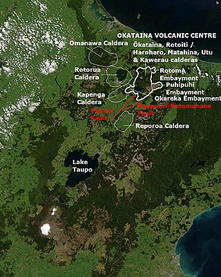
The Paeroa Fault is a seismically active area in the Taupō District, Waikato Region of the central North Island of New Zealand.

The Taupō Fault Belt contains many almost parallel active faults, and is located in the Taupō Rift of the central North Island of New Zealand geographically between Lake Taupō and the lakes of Rotorua, Tarawera, Rotomahana and Rerewhakaaitu. The potential active fault density is very high, with only 0.1 to 1 km separating the north-east to south-west orientated normal fault strands on detailed mapping of part of the belt. The Waikato River bisects the western region of the belt.

<span class="mw-page-title-main">San Diego Trough Fault Zone</span> Group of strike-slip faults along the coast of California, US

The San Diego Trough Fault Zone is a group of connected right-lateral strike-slip faults that run parallel to the coast of Southern California, United States, for 150–166 km (93–103 mi). The fault zone takes up 25% of the slip within the Inner Continental Borderlands. Portions of the fault get within 30 km (19 mi) of populated cities, however the faults never reach shore. The north of the fault zone begins where the San Pedro Basin Fault Zone and the Santa Catalina Fault Zone meet, and the southern section terminates where it reaches the Bahía Soledad Fault. Seismic risk along the fault is high, with potential earthquake scenarios reaching up to magnitude 7.9 in the worst case. An earthquake of this size would devastate coastal areas.

<span class="mw-page-title-main">Ostler Fault Zone</span> Fault zone in New Zealand

The Ostler Fault Zone is an active fault zone, to the east of the Alpine Fault in South Canterbury, South Island of New Zealand. It has had multiple recent rupture events greater than ML6.5 in magnitude, with a recent 6.9 to 7.0 event, and has recently accommodated 1.9 mm (0.075 in)/year of compression and thus land contraction.

The Hundalee Fault in northern coastal Canterbury, New Zealand had a significant rupture in the 7.8 Mw 2016 Kaikōura earthquake for a minimal length of 23 km (14 mi) and as such was a key linkage fault in this complex earthquake. It is located between Parnassus in the Hurunui District and runs off shore from near Oaro.

References

  1. 1 2 3 4 5 6 7 Norris, Richard J. (2004). "Strain localisation within ductile shear zones beneath active faults: The Alpine Fault contrasted with the adjacent Otago fault system, New Zealand" (PDF). Earth, Planets and Space. 56 (12): 1095–1101. Bibcode:2004EP&S...56.1095N. doi: 10.1186/BF03353328 .
  2. 1 2 3 4 "New seismic research on the Nevis Fault in western Otago has found there is potential it could produce a similarly-sized earthquake to the 2010 Christchurch quake" . Retrieved 2023-05-06.
  3. 1 2 3 4 5 6 7 8 9 10 11 12 13 Barrell, DJA (2018). "General distribution and characteristics of active faults and folds in the Queenstown Lakes and Central districts, Otago:GNS Science Consultancy Report 2018/207" (PDF). Retrieved 2023-05-06.
  4. 1 2 3 4 5 6 7 8 9 10 11 12 13 14 Barrell, DJA (2021). "General distribution and characteristics of active faults and folds in the Clutha and Dunedin City districts, Otago:GNS Science Consultancy Report 2020/88" (PDF). Retrieved 2023-05-06.
  5. 1 2 Norris, Richard J.; Nicolls, Ross (2004). "STRAIN ACCUMULATION AND EPISODICITY OF FAULT MOVEMENTS IN OTAGO. EQC RESEARCH REPORT 01/445" (PDF). Retrieved 2023-05-06.
  6. 1 2 Griffin, Jonathan D.; Stirling, Mark W.; Barrell, David J.A.; van den Berg, Ella J.; Todd, Erin K.; Nicolls, Ross; Wang, Ningsheng (2022). "Paleoseismology of the Hyde Fault, Otago, New Zealand". New Zealand Journal of Geology and Geophysics. 65 (4): 613–637. Bibcode:2022NZJGG..65..613G. doi: 10.1080/00288306.2021.1995007 .
  7. 1 2 3 4 Griffin, Jonathan D.; Stirling, Mark W.; Wilcken, Klaus M.; Barrell, David J. A. (2022). "Late Quaternary Slip Rates for the Hyde and Dunstan Faults, Southern New Zealand: Implications for Strain Migration in a Slowly Deforming Continental Plate Margin". Tectonics. 41 (9). Bibcode:2022Tecto..4107250G. doi: 10.1029/2022TC007250 .