Taieri Mouth

Last updated

Taieri Mouth
Rural settlement
TaieriMouth.jpg
Fishing boats moored at Taieri Mouth
Taieri Mouth
Coordinates: 46°03′15″S170°11′32″E / 46.05417°S 170.19222°E / -46.05417; 170.19222
CountryNew Zealand
Region Otago
Territorial authority Clutha District
WardBruce
Electorates
Government
  Territorial authority Clutha District Council
  Regional council Otago Regional Council
   Mayor of Clutha Bryan Cadogan
   Taieri MP Ingrid Leary
   Te Tai Tonga MP Tākuta Ferris
Area
[1]
  Total3.25 km2 (1.25 sq mi)
Population
 (June 2023) [2]
  Total280
  Density86/km2 (220/sq mi)
Time zone UTC+12 (New Zealand Standard Time)
  Summer (DST) UTC+13 (New Zealand Daylight Time)
Postcode
9091
Local iwi Ngāi Tahu

Taieri Mouth is a small fishing village at the mouth of the Taieri River, New Zealand. Taieri Island (Moturata) lies in the ocean several hundred metres off the river's mouth.

Contents

It has a white sand beach for swimming and several picnic areas. Moturata is a distinctive landmark which can be walked to at low-tide. Caution is advised as the tides can change quickly. Another feature is the millennium walking track that follows the Taieri River from the mouth through the lower gorge to Henley.

The village is located 40 km southwest of central Dunedin on the Southern Scenic Route. It is located in the Clutha District on the boundary of Dunedin City and 10 km east of Lake Waihola. Immediately to its south is the smaller settlement of Taieri Beach, and the two are often considered parts of the same settlement.

It gained a little notoriety or sadness in the 1990s as the place where the father of murder suspect David Bain worked.

History

Colourful shed at Taieri Mouth TaieriMouthShed.jpg
Colourful shed at Taieri Mouth

There was a Māori occupation site at Taieri Mouth, with moa bones, indicating it was from the Moa Hunter (early) period of Māori culture.

According to oral tradition in the early 18th century Tuwiriroa moved from Tititea on the Kawarau River near modern Queenstown and built a pa, Motupara, near Taieri Mouth. A rival, Tukiauau, had already built a pa, Whakaraupuka, inland on the Taieri Plain by Lake Waihola. Tuwiriroa had a daughter Haki Te Kura, famous for swimming across Lake Wakatipu. Tukiauau had a handsome son Korokiwhiti. The daughter and son now fell in love but the woman's father, the chief of the Taieri Mouth pa, disapproved. The young man's father was a hunted man. Hearing his enemies had discovered his whereabouts he decided to abandon the upriver settlement and move his people further south. As they came down the river in their canoes the distraught young woman attempted to jump from a rock into her lover's craft but struck the prow and was killed. Adding insult to injury her head was severed and held up angrily to her people on the shore as the flotilla passed by to the sea. There were repercussions and Tukiauau and his son were pursued and eventually killed. [3]

Bridge across the estuary of the Taieri River, Taieri Mouth Taieri Mouth Bridge.jpg
Bridge across the estuary of the Taieri River, Taieri Mouth

Maori occupation continued and Edward Shortland recorded a small settlement on the site in 1843 and Maori were still living here in 1850. [4] An early European settler was a former whaler, 'The Hermit of Taieri Mouth' (also known as John Bull) whose real name was John Edward O'Neil. He is remembered for his boisterous ways and prodigious strength. [5]

Demographics

Taieri Mouth is described by Statistics New Zealand as a rural settlement. It covers 3.25 km2 (1.25 sq mi), [1] and had an estimated population of 280 as of June 2023, [2] with a population density of 86 people per km2. It is part of the much larger Bruce statistical area. [6]

Historical population
YearPop.±% p.a.
2006189    
2013195+0.45%
2018252+5.26%
Source: [7]

Taieri Mouth had a population of 252 at the 2018 New Zealand census, an increase of 57 people (29.2%) since the 2013 census, and an increase of 63 people (33.3%) since the 2006 census. There were 108 households, comprising 132 males and 123 females, giving a sex ratio of 1.07 males per female. The median age was 52.8 years (compared with 37.4 years nationally), with 39 people (15.5%) aged under 15 years, 18 (7.1%) aged 15 to 29, 123 (48.8%) aged 30 to 64, and 72 (28.6%) aged 65 or older.

Ethnicities were 95.2% European/Pākehā, 10.7% Māori, 1.2% Pasifika, and 3.6% other ethnicities. People may identify with more than one ethnicity.

Although some people chose not to answer the census's question about religious affiliation, 54.8% had no religion, 29.8% were Christian, 1.2% had Māori religious beliefs and 1.2% had other religions.

Of those at least 15 years old, 36 (16.9%) people had a bachelor's or higher degree, and 57 (26.8%) people had no formal qualifications. The median income was $28,000, compared with $31,800 nationally. 15 people (7.0%) earned over $70,000 compared to 17.2% nationally. The employment status of those at least 15 was that 81 (38.0%) people were employed full-time, 45 (21.1%) were part-time, and 3 (1.4%) were unemployed. [7]

Education

Taieri Beach School is a co-educational state primary school for Year 1 to 8 students, [8] with a roll of 2 as of February 2024. [9] The school opened in 1862. [10]

Related Research Articles

<span class="mw-page-title-main">Otago</span> Region of New Zealand

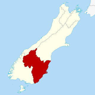
Otago is a region of New Zealand located in the southern half of the South Island administered by the Otago Regional Council. It has an area of approximately 32,000 square kilometres (12,000 sq mi), making it the country's second largest local government region. Its population was 254,600 in June 2023.

<span class="mw-page-title-main">Waikouaiti</span> Town in Otago, New Zealand

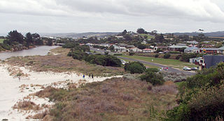
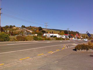
Waikouaiti is a small town in East Otago, New Zealand, within the city limits of Dunedin. The town is close to the coast and the mouth of the Waikouaiti River.

<span class="mw-page-title-main">Middlemarch, New Zealand</span> Human settlement in Dunedin City, Otago Region, New Zealand

Middlemarch is a small town in the Otago region of New Zealand's South Island. It lies at the foot of the Rock and Pillar Range of hills in the broad Strath-Taieri valley, through which flows the middle reaches of the Taieri River. Since local government reorganisation in the late 1980s, Middlemarch and much of the Strath-Taieri has been administered as part of Dunedin city, the centre of which lies some 80 km to the southeast. Middlemarch is part of the Taieri electorate, and is currently represented in parliament by Ingrid Leary. Middlemarch has reticulated sewerage but no reticulated water supply. A description of 1903, that "[T]he summer seasons are warm, but not enervating, and the winters cold, but dry" is still true today.

<span class="mw-page-title-main">Mosgiel</span> Town in Otago, New Zealand

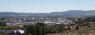
Mosgiel is an urban satellite of Dunedin in Otago, New Zealand, fifteen kilometres west of the city's centre. Since the re-organisation of New Zealand local government in 1989 it has been inside the Dunedin City Council area. Mosgiel has a population of approximately 14,800 as of June 2023. A nickname for Mosgiel is "The pearl of the plain". Its low-lying nature does pose problems, making it prone to flooding after heavy rains. Mosgiel takes its name from Mossgiel Farm, Ayrshire, the farm of the poet Robert Burns, the uncle of the co-founder in 1848 of the Otago settlement, the Reverend Thomas Burns.

<span class="mw-page-title-main">Brighton, New Zealand</span> Settlement in New Zealand

Brighton is a small seaside town within the city limits of Dunedin on New Zealand's South Island. It is located 20 kilometres southwest from the city centre on the Southern Scenic Route.

<span class="mw-page-title-main">Otakou</span> Place in Otago, New Zealand

Otakou is a settlement within the boundaries of the city of Dunedin, New Zealand. It is located 25 kilometres from the city centre at the eastern end of Otago Peninsula, close to the entrance of Otago Harbour. Though a small fishing village, Otakou is important in the history of Otago for several reasons. The settlement is the modern centre and traditional home of the Ōtākou rūnanga (assembly) of Ngāi Tahu. In 1946 Otakou Fisheries was founded in the township; this was later to become a major part of the Otago fishing industry.

<span class="mw-page-title-main">Ranfurly, New Zealand</span> Settlement in Otago, New Zealand

Ranfurly is a town in the Central Otago District of Otago, New Zealand. Located 110 kilometres north of Dunedin, it lies in the dry rough plain of Maniototo at a moderately high altitude close to a small tributary of the Taieri River. It operates as a service town for the local farming community. The town was formerly known as Eweburn, one of the "farmyard" names bestowed by former Otago Chief Surveyor John Turnbull Thomson on many small streams and locations in the district. The modern name honours the Fifth Earl of Ranfurly, who served as Governor of New Zealand (1897–1904) at the time of the extension of the Otago Central Railway to the area. Ranfurly is well known for its Art Deco buildings, such as its hotel and the milk bar.

<span class="mw-page-title-main">Karitane</span> Town in Otago, New Zealand

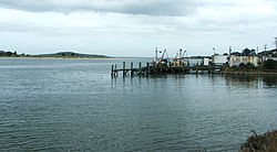
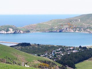
The small town of Karitane is located within the limits of the city of Dunedin in New Zealand, 35 kilometres to the north of the city centre.

<span class="mw-page-title-main">Aramoana</span> Coastal settlement in Otago, New Zealand

Aramoana is a small coastal settlement 27 kilometres (17 mi) north of Dunedin on the South Island of New Zealand. The settlement's permanent population in the 2001 Census was 261. Supplementing this are seasonal visitors from the city who occupy cribs. The name Aramoana is Māori for "pathway of the sea".

<span class="mw-page-title-main">Clutha District</span> Territorial authority district in Otago, New Zealand

Clutha District is a local government district of southern New Zealand, with its headquarters in the Otago town of Balclutha. Clutha District has a land area of 6,334.47 km2 (2,445.75 sq mi) and an estimated population of 18,900 as of June 2023. Clutha District occupies the majority of the geographical area known as South Otago.

<span class="mw-page-title-main">Outram, New Zealand</span> Town in the South Island of New Zealand

Outram is a rural suburb of Dunedin, New Zealand, with a population of 880 as of June 2023. It is located 28 kilometres west of the central city at the edge of the Taieri Plains, close to the foot of Maungatua. The Taieri River flows close to the southeast of the town. Outram lies on State Highway 87 between Mosgiel and Middlemarch.

<span class="mw-page-title-main">Coopers Beach</span> Place in Northland Region, New Zealand

Coopers Beach is a settlement on the southern side of Doubtless Bay in Northland, New Zealand. State Highway 10 runs through it. It is one of the Taipa-Mangonui string of settlements, separated from Cable Bay on the west by Otanenui Stream and from Mangōnui on the east by Mill Bay Road.

<span class="mw-page-title-main">Clinton, New Zealand</span> Town in Otago, New Zealand

Clinton is a small town in South Otago, in New Zealand's South Island. Handy to the Catlins, Dunedin, Lawrence, Central Otago and Tapanui. It is located on State Highway 1 approximately halfway between Balclutha and Gore, and the Main South Line railway passes through the town.

Allanton is a small town in Otago, New Zealand, located some 20 kilometres southwest of Dunedin on State Highway 1. The settlement lies at the eastern edge of the Taieri Plains close to the Taieri River at the junction of the main road to Dunedin International Airport at Momona.

Waitati, from the Māori Waitete, is a small seaside settlement in Otago, New Zealand, within the city limits of Dunedin. It is located close to the tidal mudflats of Blueskin Bay, 19 kilometres north of the Dunedin city centre. The small Waitati River flows through the bay to the sea.

<span class="mw-page-title-main">Warrington, New Zealand</span> Town in South Island, New Zealand

Warrington, known in Māori as Ōkāhau, is a small settlement on the coast of Otago, in the South Island of New Zealand. It is situated close to the northern shore of Blueskin Bay, an area of mudflats north of Dunedin, and is administered as part of Dunedin City. Warrington is 3 km (1.9 mi) from State Highway 1 linked by Coast Road. The Main South Line railway passes through the township and a tourist train, the Seasider passes through the settlement once or twice a week between Dunedin and Palmerston.

<span class="mw-page-title-main">Dunedin City Council</span>

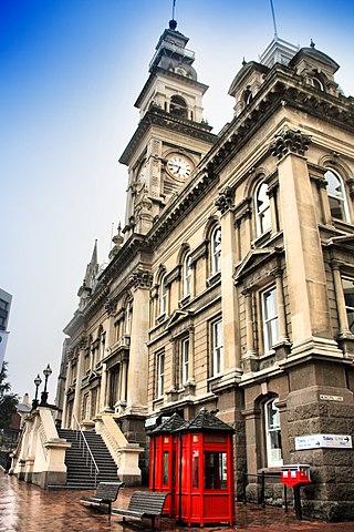
The Dunedin City Council is the local government authority for Dunedin in New Zealand. It is a territorial authority elected to represent the 134,600 people of Dunedin. Since October 2022, the Mayor of Dunedin is Jules Radich, who succeeded Aaron Hawkins. The council consists of a mayor who is elected at large, and 14 councillors elected at large, one of whom gets chosen as deputy-mayor. The councillors are elected under the Single Transferable Vote (STV) system in triennial elections, with the most recent election held on 8 October 2022.

<span class="mw-page-title-main">Waihola</span> Town in Otago, New Zealand

The township of Waihola lies between Dunedin and Milton, New Zealand in Otago, in New Zealand's South Island. It lies close to the southeast shore of the shallow tidal lake which shares its name.

<span class="mw-page-title-main">Pūrākaunui</span> Rural settlement in New Zealand

Pūrākaunui is a small settlement in Otago, in the South Island of New Zealand. It is located within the bounds of the city of Dunedin, in a rural coastal area some 25 km to the north of the city centre.

Harwood is a rural settlement on the northern side of the Otago Peninsula. It is within the boundaries of Dunedin city in New Zealand.

References

  1. 1 2 "ArcGIS Web Application". statsnz.maps.arcgis.com. Retrieved 20 January 2022.
  2. 1 2 "Subnational population estimates (RC, SA2), by age and sex, at 30 June 1996-2023 (2023 boundaries)". Statistics New Zealand . Retrieved 25 October 2023. (regional councils); "Subnational population estimates (TA, SA2), by age and sex, at 30 June 1996-2023 (2023 boundaries)". Statistics New Zealand . Retrieved 25 October 2023. (territorial authorities); "Subnational population estimates (urban rural), by age and sex, at 30 June 1996-2023 (2023 boundaries)". Statistics New Zealand . Retrieved 25 October 2023. (urban areas)
  3. Anderson, A (1998) The welcome of strangers. Dunedin: University of Otago Press ISBN   1-877133-41-8
  4. Shortland, E., (1851) The southern districts of New Zealand: A journal. London: Longman, Brown, Green & Longmans
  5. "Taieri Mouth and Taieri Beach", from The cyclopedia of New Zealand (Otago and Southland Provincial Districts). Retrieved 4 August 2013.
  6. 2018 Census place summary: Bruce
  7. 1 2 "Statistical area 1 dataset for 2018 Census". Statistics New Zealand. March 2020. 7029034.
  8. "Taieri Beach School Ministry of Education School Profile". educationcounts.govt.nz. Ministry of Education.
  9. "Taieri Beach School Education Review Office Report". ero.govt.nz. Education Review Office.
  10. De Reus, Helena (24 October 2012). "Country school celebrates". Otago Daily Times.