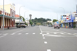
Foxton is a town in the Manawatū-Whanganui region of New Zealand - on the lower west coast of the North Island, in the Horowhenua district, 30 km (19 mi) southwest of Palmerston North and just north of Levin. The town is located close to the banks of the Manawatū River. It is situated on State Highway 1, roughly in the middle between Tongariro National Park and Wellington.

Waikanae is a town on the Kāpiti Coast, 60 kilometres north of the Wellington CBD. The name is a Māori word meaning "waters" (wai) "of the grey mullet".

Taieri Mouth is a small fishing village at the mouth of the Taieri River, New Zealand. Taieri Island (Moturata) lies in the ocean several hundred metres off the river's mouth.

The Awarua Plain is a large area of wetland to the east of Bluff, New Zealand. Covering an area of around 600 km², the plain stretches for 35 kilometres along the coast of Foveaux Strait. This stretch of coast includes the peninsula of Tiwai Point, Awarua Bay, the Waituna Lagoon, and Toetoes Bay. The Mataura River is the major river responsible for the presence of the Awarua Plain; along with the Ōreti River, it is a remnant of the rivers from the Ice Ages that formed the Southland Plains (Murihiku). In addition, several small streams enter Foveaux Strait along this stretch of coast, mainly via Awarua Bay and Waituna Lagoon.

Ōhope, is a beach settlement situated on the northeast coast of New Zealand's North Island in the Eastern Bay of Plenty. It is six kilometres east of Whakatāne and is located between Ōhiwa Harbour to the south and Ōhope Beach to the north, providing views of both.
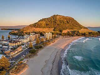
Mount Maunganui is a major residential, commercial and industrial suburb of Tauranga located on a peninsula to the north-east of Tauranga's city centre. It was an independent town from Tauranga until the completion of the Tauranga Harbour Bridge in 1988, which connects Mount Maunganui to Tauranga's central business district.

Lake Waikaremoana is located in Te Urewera in the North Island of New Zealand, 60 kilometres northwest of Wairoa and 80 kilometres west-southwest of Gisborne. It covers an area of 54 km2 (21 sq mi). From the Māori Waikaremoana translates as 'sea of rippling waters'.

Tolaga Bay is both a bay and small town on the East Coast of New Zealand's North Island located 45 kilometres northeast of Gisborne and 30 kilometres south of Tokomaru Bay.
The town of Pauanui is on the east coast of the Coromandel Peninsula in the North Island of New Zealand. It lies at the mouth of the Tairua River on its south bank, directly opposite the larger town of Tairua.

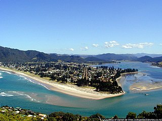
Tairua is a beachside town located on the east coast of the Coromandel Peninsula in the North Island of New Zealand in the Thames-Coromandel District. It is located 150 kilometers east of Auckland and 125 kilometers north of Tauranga. It lies at the mouth of the Tairua River on its north bank and on the small Paku Peninsula. As the 2023 census, the town had a permanent population of 1,630. It is the Tairua is a Māori name which translates literally as tai: tides, rua: two.
Taipa-Mangonui or Taipa Bay-Mangonui is a string of small resort settlements – Taipa, Cable Bay, Coopers Beach, and Mangōnui – that lie along the coast of Doubtless Bay and are so close together that they have run together to form one larger settlement.

Ōtaki is a town in the Kāpiti Coast District of the North Island of New Zealand, situated half way between the capital city Wellington, 70 km (43 mi) to the southwest, and Palmerston North, 70 km (43 mi) to the northeast.
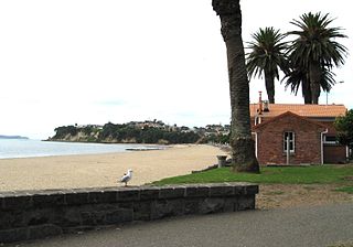
Saint Heliers is an affluent seaside suburb of Auckland with a population of 11,570 as of June 2023. This suburb is popular amongst visitors for the beaches, cafés, and views of Rangitoto Island, the distinctive volcanic island in the Hauraki Gulf.

Rotokura / Cable Bay is a bay and small settlement 18 kilometres (11 mi) north-east of Nelson in New Zealand. The settlement at the head of the bay is at the southern end of a thin strip of land or causeway connecting Pepin Island with the South Island.

Tōtaranui is a 1 km long beach and the site of a large campsite in the Tasman Region of New Zealand administered by the Department of Conservation (DOC).
Onepoto is a locality of Porirua City in New Zealand. It is bounded to the north by Whitireia Park, a large park which is slowly being returned to native bush, and to the east by the Porirua Harbour.

Golden Bay is a large shallow bay in New Zealand's Tasman District, near the northern tip of the South Island. An arm of the Tasman Sea, the bay lies northwest of Tasman Bay and Cook Strait. It is protected in the north by Farewell Spit, a 26 km long arm of fine golden sand that is the country's longest sandspit. The Aorere and Tākaka rivers are the major waterways to flow into the bay from the south and the west.

Putiki is a settlement in the Whanganui District and Manawatū-Whanganui region of New Zealand's North Island, located across the Whanganui River from Whanganui city. It includes the intersection of State Highway 3 and State Highway 4.
Waikawau is a rural community in the Waitomo District and Waikato region of New Zealand's North Island, beside Waikawau River.

Ōkiwi Bay is a small town in the Marlborough Sounds, New Zealand, within Croisilles Harbour. It has about 200 houses and about 80 permanent residents. The area was noted for its oysters.