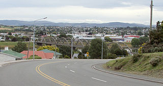
Balclutha is a town in South Otago, lying towards the end of the Clutha River, on the east coast of the South Island of New Zealand. It is about halfway between Dunedin and Gore on the Main South Line railway, State Highway 1 and the Southern Scenic Route. Balclutha has a population of 4,340, and is the largest town in South Otago.

The Catlins comprises an area in the southeastern corner of the South Island of New Zealand. The area lies between Balclutha and Invercargill, straddling the boundary between the Otago and Southland regions. It includes the South Island's southernmost point, Slope Point.

Milton, formerly known as Tokomairiro or Tokomairaro, is a town of over 2,000 people, located on State Highway 1, 50 kilometres to the south of Dunedin in Otago, New Zealand. It lies on the floodplain of the Tokomairaro River, one branch of which loops past the north and south ends of the town. This river gives its name to many local features, notably the town's only secondary school, Tokomairiro High School.
The Tokanui Branch, also known as the Seaward Bush Branch, was a branch line railway located in Southland, New Zealand. It diverged from the Bluff Branch south of the main railway station in Invercargill and ran for 54 kilometres in a southeasterly direction. Construction began in 1883 and it operated until 1966.

Beaumont is a small town in inland Otago, in the South Island of New Zealand. It is located on the Clutha River / Mata-Au six kilometres southeast of Raes Junction, between Roxburgh and Balclutha. Beaumont is connected to Milton and Roxburgh by State Highway 8.
The Catlins River Branch was a branch line railway that formed part of New Zealand's national rail network. It ran through the Catlins region in southwestern Otago and was built in sections between 1879 and 1915. It closed in 1971 except for the first four kilometres, which remain open as the Finegand Branch. Along the line was the Hunts Road tunnel, the southernmost tunnel in New Zealand.

Owaka is a small town in the Clutha District of South Otago, in the South Island of New Zealand. It is the largest community in the rugged, forested Catlins area, close to the border with Southland, some 35 km (22 mi) south of Balclutha on the Southern Scenic Route.
Romahapa is a locality in the Catlins region of Otago in New Zealand's South Island. It is located between the towns of Balclutha and Owaka. The last shop closed in 1977.

The Ōwaka River, until 2019 officially the Owaka River, flows southeastward through The Catlins, an area of the southern South Island of New Zealand. Its total length is 30 kilometres (19 mi), and it shares the estuary of the Catlins River, flowing into the Pacific Ocean at Pounawea, 28 kilometres (17 mi) south of Balclutha. Its source is on the slopes of Mount Rosebery, 12 kilometres (7.5 mi) south of Clinton. The Ōwaka River is located within the Clutha District.

The Catlins River flows southeastward through The Catlins, an area of the southern South Island of New Zealand. Its total length is 42 kilometres (26 mi), and it flows into the Pacific Ocean at the holiday settlement of Pounawea, 28 kilometres (17 mi) south of Balclutha. Its upper estuary is called Catlins Lake, and its lower estuary is shared with the Ōwaka River. The lower estuary is also known at Pounawea Estuary.
Jack's Bay is a small settlement in The Catlins, an area on the southeastern corner of the South Island of New Zealand. It is located six kilometres southwest of Owaka, close to the mouth of the Catlins River. A popular holiday spot with a seasonal population, there are numerous cribs at the settlement. Jack's Bay is noted for a large blowhole, known as Jack's Blowhole, a 55-metre-deep blowhole that formed when part of a sea cavern's roof collapsed. The blowhole is 200 metres from the sea.
Tahakopa is a small settlement in The Catlins, an area of the southern South Island of New Zealand. It is located 25 kilometres northeast of Waikawa on the Tahakopa River. On 17 February 1915, Tahakopa became the terminus of the Catlins River Branch railway and retained this status until the branch line was closed on 27 February 1971. From the line's opening until 12 August 1956, a railway locomotive depot was based in the village. The old station building and goods shed still stand today.
Tahora, later also known as Parae, is a locality in the Otago region of New Zealand's South Island, about one kilometre north of Owaka located at the Ōwaka River. Previously on a railway line, Tahora was a request stop. Today, there is little trace of the settlement and only parts of the railway formation remains visible.
Fortification is a locality in the western part of the Catlins region of Southland in New Zealand's South Island. Nearby settlements include Quarry Hills and Waikawa to the southeast, Tokanui to the southwest, and Waimahaka to the west. It is over 50 km east of Southland's main centre, Invercargill.
Finegand is a locality in the South Otago region of New Zealand's South Island.
Otanomomo is a locality in the South Otago region of New Zealand's South Island. It is situated on the banks of the Koau Branch of the Clutha River, roughly six kilometres south of Balclutha. Nearby settlements include Finegand to the north, Paretai, Puerua, and Romahapa to the south, and Waitepeka to the west.
Waiwera South is a small settlement in the South Island of New Zealand, close to the boundary between the Otago and Southland regions. The settlement is located between Balclutha and Clinton, immediately to the south of State Highway 1, between branches of the Waiwera River and Kaihiku Stream, two minor tributaries of the Clutha River. The South Island Main Trunk railway also runs through the township. The settlement's population is around 100.
Clutha District Council is the territorial authority for the Clutha District of New Zealand.
Port Molyneux is a tiny settlement on the coast of South Otago, New Zealand, close to the north-easternmost point of The Catlins. Now home only to farmland, it was a thriving port in the early years of New Zealand's European settlement.
