Related Research Articles
Henley is a township on New Zealand's Taieri Plains, named after the rowing centre Henley-on-Thames in England. It lies close to the confluence of the Taieri and Waipori Rivers at the eastern edge of the plain, at the foot of a low range of coastal hills. The township lies close to the ecologically significant Sinclair Wetlands, which lie 3.5 kilometres (2.2 mi) to the west.

Paradise is a rural locality in the Otago region of the South Island of New Zealand. It lies on the eastern side of the Dart River / Te Awa Whakatipu at the head of Lake Wakatipu, close to the settlement of Glenorchy.

St Bathans, formerly named Dunstan Creek, is a former gold and coal mining town in Central Otago, New Zealand. The settlement was a centre of the Otago gold rush, but mining has since long ceased. It is now largely a holiday retreat due to the preservation of many of its historic buildings.

The Dobson River is a river in the South Island of New Zealand. It flows south between the Neumann and Ohau ranges for 45 kilometres (28 mi) from its source on the west slope of Mount Edgar Thomson, in the Southern Alps, before joining with the Hopkins River, close to the latter's entry into the northern end of Lake Ōhau in the Mackenzie Country. The river flows over wide shingle beds, and has no rapids of interest to whitewater enthusiasts. It was named by Julius von Haast in the 1860s for his father-in-law, Edward Dobson, who was the Canterbury Provincial Engineer. The Māori name, also given as Otao in some works, means "driftwood," and has also been applied to the Hopkins River into which the Dobson/Ōtaao flows.

Beaumont is a small town in inland Otago, in the South Island of New Zealand. It is located on the Clutha River / Mata-Au six kilometres southeast of Raes Junction, between Roxburgh and Balclutha. Beaumont is connected to Milton and Roxburgh by State Highway 8.
The Catlins Ranges are a series of rugged, roughly parallel hill ranges in the southeastern corner of New Zealand's South Island.
The Earnscleugh or Fraser River is a river of the Otago Region of New Zealand. It arises in the Old Man Range and flows north-east to the Fraser Dam, then south-east to the Clutha River about 4 km west of Alexandra. The name Earnscleugh is given to the upper reaches of the river. The lower reaches are called the Fraser River, after one of the owners of Earnscleugh Station, William Fraser, who introduced rabbits to the area.

Bendigo is a settlement and historic area in Central Otago, South Island of New Zealand. It is located some 20 kilometres to the north of Cromwell, to the east of the head of Lake Dunstan, on the banks of the Bendigo Creek, a small tributary of the Clutha River.
The small settlement of Caberfeidh is located in The Catlins, in the Otago region of New Zealand's South Island. The site of a former railway station on the Catlins Branch Line, it is sited close to a tributary of the Maclennan River, 5 kilometres north of the coast at Tahakopa Bay and 12 kilometres southwest of Owaka.
Waiwera South is a small settlement in the South Island of New Zealand, close to the boundary between the Otago and Southland regions. The settlement is located between Balclutha and Clinton, immediately to the south of State Highway 1, between branches of the Waiwera River and Kaihiku Stream, two minor tributaries of the Clutha River. The South Island Main Trunk railway also runs through the township. The settlement's population is around 100.
Gummies Bush is a farming locality in Southland, New Zealand, 10 kilometres (6.2 mi) west of the Aparima River, 9 kilometres (5.6 mi) north of Riverton, and 18 kilometres (11 mi) south from Otautau. It is said to be named after whaler and later pig-farmer James Leader, nicknamed "Gummie" because he had no teeth. Leader had a camp in the bush in this location. To Māori, the area was known as Opuaki. It was apparently named after a person, Puaki, a word which means "to come forth in position," or "to come forth in language – that is to utter.
Lauder is a small settlement in the Otago Region of the South Island of New Zealand. It is located in Central Otago, 8 km northeast of Omakau, on the main route between Alexandra and Ranfurly, State Highway 85. The settlement was named after the town of the same name in southern Scotland, one of many Otago sites to be named after places in the Scottish borders by John Turnbull Thomson.
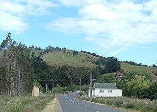
Kyeburn is a small settlement in Otago, in the South Island of New Zealand. It lies on the Maniototo, a wide, high plain stretching from the end of the Strath-Taieri valley.
Wangaloa is a small coastal settlement in South Otago, New Zealand. It is located to the north of the mouths of the Clutha River the beach area, close to the town of Kaitangata. There is access to Wangaloa Beach from the Kaitangata Golf course. Wangaloa is connected to Toko Mouth, 10 kilometres (6.2 mi) to the north, by a coastal road, and to Kaitangata, 5 kilometres (3.1 mi) to the west, by a road which crests a low range of coastal hills.
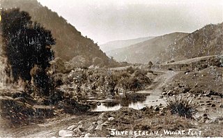
Whare Flat is a locality some 15 km to the northwest of Dunedin city centre, in the South Island of New Zealand. It is located at a widening of the Silver Stream's valley amid the foothills of the Silverpeaks.
Tariki is a small farming community immediately to the east of Mount Taranaki in the west of New Zealand's North Island. It lies on SH 3 halfway between the towns of Inglewood and Stratford. Several small streams, all tributaries of the Manganui River, pass close to Tariki.
Oaro is a settlement close to the Pacific Ocean Coast of north Canterbury, in the South Island of New Zealand.
Maruakoa is a small farming settlement in Waitaki District, New Zealand. It is located close to the banks of the Kakanui River just south of its emergence form the Kakanui Gorge. It is 18 kilometres northwest of Oamaru and 4 kilometres southwest of Windsor, between the two settlements of Five Forks and Tapui. The name Maruakoa is a Māori word literally meaning "Happy valley".
Crookston is a small rural settlement in West Otago, in the South Island of New Zealand. It is located on SH 90 between Tapanui and Edievale, and lies 6 km east of Heriot.
The Koau and Matau Rivers, also called the Koau and Matau Branches, are the two distributaries of New Zealand's Clutha River. The two distributaries split immediately to the southeast of the town of Balclutha, at which point the more northerly branch becomes the Matau and the more southerly becomes the Koau. The two branches both flow generally southeast to reach the Pacific Ocean, surrounding the island of Inch Clutha. A small silty channel connects the two rivers close to their mouths, creating a smaller unnamed island to the south of Inch Clutha.
References
- ↑ Dowling, P. (ed.) (2004). ’’Reed New Zealand atlas’’. Auckland: Reed Publishing. Map 111. ISBN 0 7900 0952 8
- ↑ Wise's New Zealand guide (1969) Dunedin: H. Wise & Co. p. 188.
- ↑ Reed, A.W. (1975). Place names of New Zealand. Wellington: A.H. & A.W. Reed. pp. 271–272.
46°09′30″S169°54′15″E / 46.15833°S 169.90417°E
| | This Otago geography article is a stub. You can help Wikipedia by expanding it. |