Kelso, New Zealand

Last updated
The Kelso Monument, showing flood levels; an old railway shed in the background Kelso Monument.JPG
The Kelso Monument, showing flood levels; an old railway shed in the background

Kelso is an abandoned small settlement in Otago, New Zealand, located ten kilometres north of Tapanui on the Crookston Burn, close to its junction with the larger Pomahaka River. [1] Its population during the 1960s and 1970s was close to 300, with most of its economy based on sheep farming. A small dairy factory was a focal point in the village's early years.

The township was first surveyed in 1875, and the first settlement began the following year. It was named by John Turnbull Thomson for the Scottish home town of one of the town's first settlers, James Logan. [2] Originally intended as the main settlement in the West Otago area, this title eventually went to nearby Tapanui. The town was linked to Waipahi and the Main South Line railway on 1 December 1880 with the opening of the Tapanui Branch line. On 1 April 1884, this line was extended from Kelso to Heriot.

The township was frequently subject to flooding, notably in 1913 and 1917. It was inundated with flood water during two major floods of the Clutha River catchment in 1978 and 1980. The former led to the closure of the railway, and after the latter flood it was decided to relocate the settlement entirely.

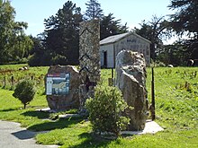
Today, little remains to indicate the location of Kelso, other than a stone memorial and faded wording referring to the township on several remaining buildings.

A book of the history of Kelso was written by May Brownlie, called Kismet for Kelso (published 1992).

Related Research Articles

<span class="mw-page-title-main">Clutha River</span> River in the South Island of New Zealand

The Clutha River is the second longest river in New Zealand and the longest in the South Island. It flows south-southeast 338 kilometres (210 mi) through Central and South Otago from Lake Wānaka in the Southern Alps to the Pacific Ocean, 75 kilometres (47 mi) south west of Dunedin. It is the highest volume river in New Zealand, and the swiftest, with a catchment of 21,960 square kilometres (8,480 sq mi), discharging a mean flow of 614 cubic metres per second (21,700 cu ft/s). The river is known for its scenery, gold-rush history, and swift turquoise waters. A river conservation group, the Clutha Mata-Au River Parkway Group, is working to establish a regional river parkway, with a trail, along the entire river corridor.

<span class="mw-page-title-main">Milton, New Zealand</span> Town in New Zealand

Milton, formerly known as Tokomairiro or Tokomairaro, is a town of over 2,000 people, located on State Highway 1, 50 kilometres to the south of Dunedin in Otago, New Zealand. It lies on the floodplain of the Tokomairaro River, one branch of which loops past the north and south ends of the town. This river gives its name to many local features, notably the town's only secondary school, Tokomairiro High School.

South Otago lies in the south east of the South Island of New Zealand. As the name suggests, it forms the southernmost part of the geographical region of Otago.

<span class="mw-page-title-main">Tapanui</span> Town in Otago, New Zealand

Tapanui is a small town in West Otago in New Zealand's South Island, close to the boundary with Southland region.

West Otago is the local name given to part of the region of Otago, New Zealand, lying close to the border with Southland. It is administratively connected to South Otago, but is geographically separated from it by a range of hills known as the Blue Mountains. The largest settlements in West Otago are Tapanui and Heriot, and other localities within the area include Moa Flat, Edievale, Crookston, Merino Downs, and Waikoikoi. The area described as West Otago is sometimes extended to include Lawrence, Clinton, and Beaumont. The ghost town of Kelso also lies within West Otago. Other notable features of the area include Conical Hill and Landslip Hill, the latter being a major fossil-bearing formation.

<span class="mw-page-title-main">Strath Taieri</span>

Strath Taieri is a large glacial valley and river plateau in New Zealand's South Island. It is surrounded by the rugged hill ranges to the north and west of Otago Harbour. Since 1989 it has been part of the city of Dunedin. The small town of Middlemarch is located at its southern end.

The Pomahaka River is in South Otago in New Zealand's South Island. It is a tributary of the Clutha River, flowing south for 80 kilometres (50 mi) from the Old Man Range / Kopuwai mountains to join the Clutha about 15 km west of Balclutha. Along its path it passes the Blue Mountains and the forestry town of Tapanui in the area known locally as West Otago.

The Waikaka branch was a branch line railway of the Main South Line that ran through agricultural and gold-mining country in Southland, New Zealand. It was constructed in 1907 and 1908, and was operated by the New Zealand Railways Department until its closure in 1962.

The Tapanui Branch was a railway line located near the border of the regions of Southland and Otago, New Zealand. Although the name suggests that it terminated in Tapanui, its furthest terminus was actually in Edievale. Construction of the line began in 1878 with the first section opened in 1880, and it operated until 1978, when it was destroyed by flooding from the Pomahaka River.

<span class="mw-page-title-main">Beaumont, New Zealand</span> Settlement in Clutha District, Otago Region, New Zealand

Beaumont is a small town in inland Otago, in the South Island of New Zealand. It is located on the Clutha River / Mata-Au six kilometres southeast of Raes Junction, between Roxburgh and Balclutha. Beaumont is connected to Milton and Roxburgh by State Highway 8.

<span class="mw-page-title-main">Waikaia Branch</span> Closed South Island railway branch line

The Waikaia Branch, also known as the Switzers Branch, was a branch line railway in Southland, New Zealand. Proposed as early as the 1870s, it was not opened until 1909 and was operated by the New Zealand Railways Department for half a century until its closure in 1959.

Blue Mountains are a range of rugged hills in West Otago, in southern New Zealand. They form a barrier between the valleys of the Clutha and Pomahaka Rivers. They lie between the towns of Tapanui and Lawrence and rise to 1019 metres (3280 ft).

<span class="mw-page-title-main">Hyde, New Zealand</span> Town in Otago, New Zealand

Hyde is a locality in Otago, New Zealand, located in the Strath-Taieri. It is close to the northern end of the Rock and Pillar Range on State Highway 87 between Middlemarch and Ranfurly. Hyde is best known as the site of the Hyde railway disaster of 4 June 1943, in which 21 people were killed when an express train on the Otago Central Railway derailed at high speed in a cutting near the town. At the time, it was the worst railway accident in New Zealand's history; it has only been passed by the Tangiwai disaster of 24 December 1953, which claimed the lives of 151 people. The site of the Hyde disaster can now be walked as part of the Otago Central Rail Trail and a monument, a 2.5 m high cairn, stands as a memorial to the victims.

Heriot is a small settlement in West Otago, in the South Island of New Zealand. It is located 20 kilometres southwest of Raes Junction and 15 kilometres north of Tapanui.

The small settlement of Caberfeidh is located in The Catlins, in the Otago region of New Zealand's South Island. The site of a former railway station on the Catlins Branch Line, it is sited close to a tributary of the Maclennan River, 5 kilometres north of the coast at Tahakopa Bay and 12 kilometres southwest of Owaka.

Waiwera South is a small settlement in the South Island of New Zealand, close to the boundary between the Otago and Southland regions. The settlement is located between Balclutha and Clinton, immediately to the south of State Highway 1, between branches of the Waiwera River and Kaihiku Stream, two minor tributaries of the Clutha River. The South Island Main Trunk railway also runs through the township. The settlement's population is around 100.

Lauder is a small settlement in the Otago Region of the South Island of New Zealand. It is located in Central Otago, 8 km northeast of Omakau, on the main route between Alexandra and Ranfurly, State Highway 85. The settlement was named after the town of the same name in southern Scotland, one of many Otago sites to be named after places in the Scottish borders by John Turnbull Thomson.

Edievale is a small settlement in West Otago, in New Zealand's South Island. It lies equidistant between Heriot, which lies to the west, and Raes Junction, which lies to the east, on State Highway 90.

Port Molyneux is a tiny settlement on the coast of South Otago, New Zealand, close to the north-easternmost point of The Catlins. Now home only to farmland, it was a thriving port in the early years of New Zealand's European settlement.

Crookston is a small rural settlement in West Otago, in the South Island of New Zealand. It is located on SH 90 between Tapanui and Edievale, and lies 6 km east of Heriot.

References

  1. LINZ Topomap G44
  2. Reed, A. W. (2010). Peter Dowling (ed.). Place Names of New Zealand. Rosedale, North Shore: Raupo. p. 201. ISBN   9780143204107.

45°54′S169°14′E / 45.900°S 169.233°E / -45.900; 169.233