Tapanui Branch

Last updated

Tapanui Branch
Overview
Other name(s)Kelso Branch
StatusClosed
Owner Railways Department
Locale Otago, New Zealand
Termini
Stations7
Service
Type Heavy Rail
System New Zealand Government Railways (NZGR)
Operator(s) Railways Department
History
Opened1880
Extended to Heriot1884
Extended to Edievale1905
Closed beyond Heriot1968
Closed1978
Technical
Line length42.3 km (26.3 mi)
Number of tracksSingle
CharacterRural
Track gauge 3 ft 6 in (1,067 mm)
Route map

Contents

km
 
BSicon CONTgq.svg
BSicon eABZq+l.svg
BSicon exlHST.svg
BSicon CONTf@Fq.svg
0
Waipahi
BSicon v-WASSER.svg
BSicon v-WASSER+r.svg
BSicon exSTR.svg
BSicon dWASSER.svg
BSicon exTUNNEL2.svg
Conical Hill tunnel
BSicon v-WASSERl.svg
BSicon exhKRZWae.svg
BSicon vWASSER+r-.svg
BSicon exHST.svg
BSicon vWSHI2l-.svg
7
Conical Hill
BSicon exHST.svg
BSicon v-WSHI2r.svg
13
Pomahaka
BSicon exHST.svg
BSicon WSHI1+r.svg
17
Glenkenich
BSicon exBHF.svg
BSicon WASSER.svg
21
Tapanui
BSicon WASSERq.svg
BSicon exhKRZWae.svg
BSicon WABZgr.svg
BSicon exHST.svg
BSicon WSHI1r.svg
25
Kelso
BSicon exSTRc2.svg
BSicon exHST3.svg
BSicon vWASSERlg-.svg
32
Heriot
BSicon exKHST1.svg
BSicon exSTRc4.svg
42
Edievale
Tapanui Branch
Map

The Tapanui Branch was a railway line located near the border of the regions of Southland and Otago, New Zealand. Although the name suggests that it terminated in Tapanui, its furthest terminus was actually in Edievale. Construction of the line began in 1878 with the first section opened in 1880, and it operated until 1978, when it was destroyed by flooding from the Pomahaka River.

Construction

In the second half of the 19th century, farmers in the region desired a railway connection to enhance the value of their land and provide easier access to markets, and received support from interests in Dunedin, who, in the days before the abolition of provinces in 1876, feared a loss of trade to Invercargill. In 1877, district engineer W. N. Blair proposed a route to Central Otago via Tapanui, but this proved unpopular outside of Tapanui and its immediate surrounds. However, approval was granted for the construction of a branch line in the area and construction began in 1878, leaving the Main South Line at Waipahi, located 50 kilometres west of Balclutha. The first locomotive for the line was delivered on 8 July 1880 and the Public Works Department began operating trains to Tapanui three days later. The official opening ceremony in Tapanui was held on 24 November 1880, though the actual line, at 25.13 kilometres in length, was opened to a settlement just beyond Tapanui named Kelso on 1 December 1880. In this year, it was proposed to build a line westwards to the Waikaia area from Kelso, but the proposals came to nothing and the Waikaia Branch was built from Riversdale on the Waimea Plains Railway instead.

An extension of 7.11 kilometres from Kelso to Heriot was opened on 1 April 1884. The local newspaper, the Tapanui Courier, believed that only a short tunnel and some clay cuttings in the Dunrobin Hills stood in the way of extending the railway line to the Clutha River and then on to Roxburgh. In 1900, the government chose to extend the railway from Heriot to Edievale pending a final decision on the route to Roxburgh, and this ten kilometre extension was opened on 18 February 1905, bringing the branch's total length to 42.3 kilometres. Edievale proved to be the final terminus when the line from Milton via Lawrence was extended to Roxburgh instead.

Stations

The following stations were located on the Tapanui Branch (in brackets is the distance in kilometres from the junction in Waipahi):

Operation

In the early days, a mixed train operated from Edievale daily. These mixed trains connected with mainline expresses and local Invercargill-Clinton services at the junction in Waipahi. The line was indispensable before the expansion of decent road networks, but as improvements came in road transport in the 20th century, traffic began to decline. The Great Depression did not help the line's fortunes, with revenue dropping as fast as expenditure was rising in 1930. To save money, passenger services on the line were cancelled and replaced by buses, thus making the mixed trains goods-only, and the Edievale locomotive depot closed on 1 January 1934. The freight service was run when required, operating regularly on weekdays for many years, but it continued to lose money. The under-utilised section from Heriot to Edievale was closed on 1 January 1968 as it only saw 4,000 tonnes of traffic a year, but enough traffic existed to justify the existence of the rest of the line for a few more years, with tonnages varying between 30,000 and 60,000 tonnes in the 1970s. The freight carried at this time was mainly from the State Forest's Conical Hill Sawmill located nine kilometres up the line, and phosphate from the Southland Co-op Phosphate Co.'s works near Bluff to West Otago Transport in Heriot. In March 1969, trains were re-organised to operate from Gore, and the aged A class steam locomotives that typically ran trains on the branch were replaced by DJ class diesel-electric engines (steam locomotive power fully disappeared from New Zealand's railway system by the end of 1971). [1]

Catastrophe hit the line in mid-October 1978. Extremely severe flooding along the Pomahaka River demolished bridges and washed out the trackage in many places, and costly repairs would not have been economic. Formal closure was confirmed two months later in December.

Before its closure in 1962, the Waikaka Branch ran in a valley parallel to that occupied by the Tapanui Branch, and trivia associated with operation of the lines is that locomotive crews in one valley claimed they were sometimes able to see smoke from a steam engine operating in the other valley.

Today

The railway goods shed at Kelso sits behind a monument to the Kelso flood. Kelso Monument.JPG
The railway goods shed at Kelso sits behind a monument to the Kelso flood.

Relics of this branch survive today, though as time progresses, remnants of old railways deteriorate and in some cases disappear entirely, so what was previously evident may no longer exist. Bridges sans rails are believed to still exist in the early stages of the line, notably including a truss bridge across the Pomahaka River. The Tapanui railway station and yard were never in Tapanui township; they were situated approximately 2 km away in a field adjacent to the Station Rd level crossing. The Tapanui railway yard precinct remains obvious, as are the stands of macrocarpa trees that once defined its limits, although the station building is gone. The hump in Station Rd that was the level crossing and an old commercial building beside the level crossing also remain. Flooding almost entirely destroyed Kelso and it is now abandoned, though the railway's second goods shed still exists. On lower ground is the ruins of the town's former service station, with sombre viewing created by flood levels marked on the doors.

There was "still plenty to see" in the 1990s, and "the flood markings alone are sobering". [2] The large Heriot goods shed is understood to have been removed in the late 1990s. [3]

Related Research Articles

The Pomahaka River is in South Otago in New Zealand's South Island. It is a tributary of the Clutha River, flowing south for 80 kilometres (50 mi) from the Old Man Range / Kopuwai mountains to join the Clutha about 15 km west of Balclutha. Along its path it passes the Blue Mountains and the forestry town of Tapanui in the area known locally as West Otago.

The Waikaka Branch was a branch line railway of the Main South Line that ran through agricultural and gold-mining country in Southland, New Zealand. It was constructed in 1907 and 1908, and was operated by the New Zealand Railways Department until its closure in 1962.

<span class="mw-page-title-main">Main South Line</span> Railway line in New Zealand

The Main South Line, sometimes referred to as part of the South Island Main Trunk Railway, is a railway line that runs north and south from Lyttelton in New Zealand through Christchurch and along the east coast of the South Island to Invercargill via Dunedin. It is one of the most important railway lines in New Zealand and was one of the first to be built, with construction commencing in the 1860s. At Christchurch, it connects with the Main North Line to Picton, the other part of the South Island Main Trunk.

The Tokanui Branch, also known as the Seaward Bush Branch, was a branch line railway located in Southland, New Zealand. It diverged from the Bluff Branch south of the main railway station in Invercargill and ran for 54 kilometres in a southeasterly direction. Construction began in 1883 and it operated until 1966.

The Wyndham Branch, also known as the Glenham Branch, was a branch line railway in Southland, New Zealand. The first section was opened in 1882 and it operated until 1962. Although its name would imply that it terminated in Wyndham, an extension to a terminus in Glenham operated for forty years. It was operated by the New Zealand Railways Department.

The Waimate Branch was a branch line railway built in southern Canterbury, New Zealand to link the Main South Line with the town of Waimate, the centre of the surrounding rural area. It opened in 1877 and operated until 1966; for some of this time, it included an extension to Waihao Downs that was known as the Waimate Gorge Branch or Waihao Downs Branch. When the line closed, Waimate received the dubious distinction of being New Zealand's first major town to lose its railway line.

The Methven Branch was a branch line railway that was part of New Zealand's national rail network in Canterbury. It opened in 1880 and operated until 1976.

The Mount Somers Branch, sometimes known as the Springburn Branch, was a branch line railway in the region of Canterbury, New Zealand. The line was built in stages from 1878, reaching Mount Somers in 1885. A further section to Springburn was added in 1889; this closed in 1957, followed by the rest of the line in 1968. A portion has been preserved as the Plains Vintage Railway.

<span class="mw-page-title-main">Kingston Branch</span> Railway line in Southland, New Zealand.

The Kingston Branch was a major railway line in Southland, New Zealand. It formed part of New Zealand's national rail network for over a century: construction began in 1864, Kingston was reached in 1878, and it closed in 1979. For much of its life, it was considered a secondary main line rather than a branch line, and in its earlier years, it was sometimes known as the "Great Northern Railway". Today, the southern portion now forms a part of the Wairio Branch and the northernmost 14 kilometres was used by the Kingston Flyer.

The Waimea Plains Railway was a secondary railway line that linked the towns of Lumsden and Gore in northern Southland, New Zealand. It skirted the Hokonui Hills, and operated as a through route between 31 July 1880 and 1 April 1971, with the short section from Lumsden to Balfour continuing as the Balfour Branch until 15 January 1978.

<span class="mw-page-title-main">Waikaia Branch</span> Closed South Island railway branch line

The Waikaia Branch, also known as the Switzers Branch, was a branch line railway in Southland, New Zealand. Proposed as early as the 1870s, it was not opened until 1909 and was operated by the New Zealand Railways Department for half a century until its closure in 1959.

The Mossburn Branch was a branch line railway in New Zealand from Lumsden on the Kingston Branch to the town of Mossburn in northern Southland. Construction began in 1879, Mossburn was reached in 1887, and the line closed in 1982. It was operated by the New Zealand Railways Department.

The Tuatapere Branch, including the Orawia Branch, was a branch line railway in Southland, New Zealand. Although the Tuatapere and Orawia Branches look like a single line, operationally they were considered separate lines. The first section opened to Riverton in 1879 and reached Tuatapere three decades later. The extension from Tuatapere to Orawia operated from 1925 until 1970. In 1976 the Tuatapere Branch was truncated to Riverton, and was known as the Riverton Branch until 1978, when it closed beyond Thornbury. The remaining portion of the line is now part of the Wairio Branch.

<span class="mw-page-title-main">NZR RM class (Clayton)</span>

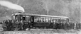
The NZR RM class Clayton steam rail motor was a unique railcar that was operated by New Zealand Railways (NZR) for New Zealand's national rail network and one of only two steam railcars to operate in New Zealand - the other being 1925's RM class Sentinel-Cammell.

<span class="mw-page-title-main">Otago Central Railway</span> Branch railway line in Otago, New Zealand

The Otago Central Railway (OCR) or in later years Otago Central Branch Railway, now often referred to as the Taieri Gorge Railway, was a secondary railway line in Central Otago, in the South Island of New Zealand.

The Kurow Branch was part of New Zealand's national rail network. In the North Otago region of the South Island, it was built in the 1870s to open up the land behind Oamaru for development, and closed in 1983.

The Roxburgh Branch was a branch line railway built in the Otago region of New Zealand's South Island that formed part of the country's national rail network. Originally known as the Lawrence Branch, it was one of the longest construction projects in New Zealand railway history, beginning in the 1870s and not finished until 1928. The full line was closed in 1968.

The Dunback and Makareao Branches were two connected branch line railways, part of New Zealand's national rail network. Located in the Otago region of the South Island, both lines were 15 kilometres (9.3 mi) in length and shared the first 11 kilometres (6.8 mi). The Dunback Branch, also known as the Waihemo Branch, opened in 1885 and closed in 1968; the Makareao Branch, also known as the Inch Valley Railway or the Inch Valley Branch, opened in 1900 and operated for 89 years to 1989.

<span class="mw-page-title-main">Seddonville Branch</span>

The Seddonville Branch, later truncated as the Ngākawau Branch, is a branch line railway in the West Coast region of New Zealand's South Island. Construction began in 1874 and it reached its terminus at the Mokihinui Mine just beyond Seddonville in 1895. In 1981 it was closed past Ngākawau and effectively became an extension of the Stillwater–Westport Line, since formalised as the Stillwater–Ngākawau Line.

<span class="mw-page-title-main">Kelso, New Zealand</span>

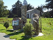
Kelso is an abandoned small settlement in Otago, New Zealand, located ten kilometres north of Tapanui on the Crookston Burn, close to its junction with the larger Pomahaka River. Its population during the 1960s and 1970s was close to 300, with most of its economy based on sheep farming. A small dairy factory was a focal point in the village's early years.

References

Citations

Bibliography

  • Churchman, Geoffrey B; Hurst, Tony (2001) [1990, 1991]. The Railways of New Zealand: A Journey through History (Second ed.). Transpress New Zealand. ISBN   0-908876-20-3.
  • Leitch, David; Scott, Brian (1995). Exploring New Zealand's Ghost Railways (1998 ed.). Wellington: Grantham House. ISBN   1-86934-048-5.
  • Hermann, Bruce J; South Island Branch Lines p 34 (1997, New Zealand Railway & Locomotive Society, Wellington) ISBN   0-908573-70-7
  • Mulligan, Barbara (2000). New Zealand Rail Trails: A Guide to 42 Ghost Lines. Wellington: Grantham House Publishing. pp. 170–174. ISBN   978-1-86934-126-8.