The Waikaka branch was a branch line railway of the Main South Line that ran through agricultural and gold-mining country in Southland, New Zealand. It was constructed in 1907 and 1908, and was operated by the New Zealand Railways Department until its closure in 1962.
The Shag Point Branch was a short branch off the Main South Line on the east coast of the South Island of New Zealand. It left the main line about nine kilometres north of Palmerston at the small settlement of Shag Point to provide railway access to a nearby supply of coal. It was built in 1879 and ran until 1934.

The Foxton Branch was a railway line in New Zealand. It began life as a tramway, reopened as a railway on 27 April 1876, and operated until 18 July 1959. At Himatangi there was a junction with the Sanson Tramway, a line operated by the Manawatu County Council that was never upgraded to the status of a railway.
The Mount Somers Branch, sometimes known as the Springburn Branch, was a branch line railway in the region of Canterbury, New Zealand. The line was built in stages from 1878, reaching Mount Somers in 1885. A further section to Springburn was added in 1889; this closed in 1957, followed by the rest of the line in 1968. A portion has been preserved as the Plains Vintage Railway.
The Waimea Plains Railway was a secondary railway line that linked the towns of Lumsden and Gore in northern Southland, New Zealand. It skirted the Hokonui Hills, and operated as a through route between 31 July 1880 and 1 April 1971, with the short section from Lumsden to Balfour continuing as the Balfour Branch until 15 January 1978.

The Waikaia Branch, also known as the Switzers Branch, was a branch line railway in Southland, New Zealand. Proposed as early as the 1870s, it was not opened until 1909 and was operated by the New Zealand Railways Department for half a century until its closure in 1959.
The Kurow Branch was part of New Zealand's national rail network. In the North Otago region of the South Island, it was built in the 1870s to open up the land behind Oamaru for development, and closed in 1983.

The Raetihi Branch was a branch line railway in the central North Island of New Zealand. It formed part of New Zealand's national rail network and operated from 1917 until 1968.

The Te Aro Extension, also known as the Te Aro Branch, was a short branch line railway in Wellington, New Zealand continuing the Wairarapa Line southwards. It operated from 1893 until 1917.

The New Plymouth Express was a passenger express train operated by the New Zealand Railways Department (NZR) between Wellington and New Plymouth. It ran from 1886 until 1955 and was sometimes known as the New Plymouth Mail due to the Railway Travelling Post Office carriages included in its consist. The Express was notable amongst NZR's provincial expresses as being both the first and, until the commencement of the Gisborne Express in 1942, the longest in distance travelled.
The Taranaki Flyer was the name given to a passenger train that was operated by the New Zealand Railways Department between Whanganui and New Plymouth from 1926 to 1965.
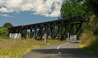
The Stratford–Okahukura Line (SOL) is a secondary railway line in the North Island of New Zealand, between the Marton - New Plymouth Line (MNPL) and the North Island Main Trunk (NIMT) Railway, with 15 intermediate stations. It is 144 km (89 mi) long through difficult country, with 24 tunnels, 91 bridges and a number of sections of 1 in 50 grade. Near Okahukura there is an unusual combined road-rail bridge over the Ongarue River, with the one-lane road carriageway below the single rail track. The line is not currently in service for rail traffic and is under a 30-year lease for a tourist venture. In July 2019 KiwiRail's CEO stated that reopening the line was a priority. Minister of Transport Michael Wood announced the government's 10-year plan for rail investment on 6 May 2021, which specifically stated that plans could include re-opening the Stratford to Okahukura line.
The Marton–New Plymouth line (MNPL) is a secondary main line railway in the North Island of New Zealand that links the Taranaki and Manawatū-Whanganui regions. It branches from the North Island Main Trunk railway (NIMT) at Marton and runs near the South Taranaki Bight of the west coast before turning inland, meeting the Stratford–Okahukura Line (SOL) at Stratford and running to New Plymouth. Construction of the line was completed in 1885, and along with the SOL it provided an alternate route to the NIMT from the SOL's completion in 1933 until the latter was mothballed in 2010. In its early days it was plied by the North Island's first regional express, the New Plymouth Express, but it has been freight only since the cancellation of the last passenger services in 1977.
The Wanganui Branch is a 5.00 km branch line railway in the Manawatū-Whanganui region of New Zealand's North Island. It links Wanganui with the Marton - New Plymouth Line (MNPL) at Aramoho and has been open since 21 January 1878, although solely for freight traffic since 7 September 1959. Another branch line diverged from the Wanganui Branch near its terminus, the Castlecliff Branch.

The Castlecliff Branch is a branch line railway 5.88 km long in the Manawatu-Whanganui region of New Zealand's North Island. It is an extension of the Wanganui Branch from Taupo Quay in central Whanganui and follows the Whanganui River to Castlecliff on the South Taranaki Bight of the Tasman Sea. From its opening on 31 October 1885 until 1 February 1956 when the NZR took over, it was owned by the Wanganui Heads Railway Company, later renamed the Castlecliff Railway Company. From 5 September 2006 services on the branch were suspended but the infrastructure remained in place. In 2011 KiwiRail resumed services on part of the line.
The Waitara Branch is a 7.245 km long branch line railway in the Taranaki region of New Zealand's North Island. It was built as part of the region's first railway, linking New Plymouth with the closest suitable port, then the river port of Waitara. In 1884 the Breakwater port was opened in New Plymouth, but the line was saved when a (meat) freezing works was opened at Waitara in 1885.

The Cape Foulwind Railway was a branch railway line west of Westport to Cape Foulwind. In 1886 the Westport Harbour Board built the line to their quarry to transport rocks to their breakwaters in the Buller River. In 1888 it was linked to Westport by a road-rail bridge over the Buller River. The iron bridge was planked with kauri forming a 12 ft (3.7 m) wide road. The bridge cost £13,794 and was 1,040 ft (320 m) long. By 1888 it was said to be carrying a considerable passenger traffic, using two coaches. In 1914 a new section of line including a tunnel was built to a new quarry south of the Cape.
The Moutohora Branch was a branch line railway that formed part of New Zealand's national rail network in Poverty Bay in the North Island of New Zealand. The branch ran for 78 km approximately North-West from Gisborne into the rugged and steep Raukumara Range to the terminus at Moutohora. Construction started in 1900, and the line was opened to Moutohora on 26 November 1917.
The Ngatapa Branch was a secondary branch line railway 18.5 kilometres (11.5 mi) long that for a short time formed part of the national rail network in Poverty Bay in the North Island of New Zealand. The Ngatapa branch diverged from the Moutohora branch line about 6 kilometres (3.7 mi) from Gisborne and ran a further 12.5 kilometres (7.8 mi) across the coastal flat to a terminus at Ngatapa. It was sometimes referred to as the Ngapata branch.
The Kapuni Branch, formerly known as the Opunake Branch, is a branch railway in North Island, New Zealand. It opened in 1926, and ran 36.4 km across the southern slopes of Mount Taranaki to link the rural town of Ōpunake with the Marton–New Plymouth Line 2 km north of the small rural settlement of Te Roti, equidistant between Eltham and Hāwera. With the decline of rural freight, part of the line was closed in 1976, but the 10.9 km section to Kapuni was retained and upgraded to service traffic to the Kapuni natural gas field.
