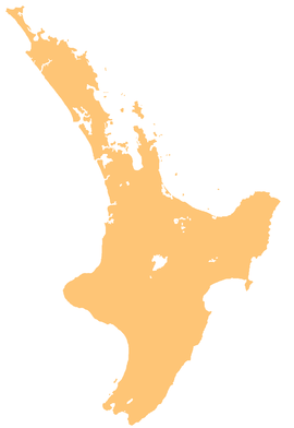
Taranaki is a region in the west of New Zealand's North Island. It is named after its main geographical feature, the stratovolcano Mount Taranaki, also known as Mount Egmont.
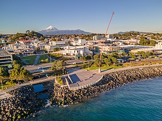
New Plymouth is the major city of the Taranaki region on the west coast of the North Island of New Zealand. It is named after the English city of Plymouth, in Devon, from where the first English settlers to New Plymouth migrated. The New Plymouth District, which includes New Plymouth City and several smaller towns, is the 10th largest district in New Zealand, and has a population of 88,900 – about two-thirds of the total population of the Taranaki Region and 1.7% of New Zealand's population. This includes New Plymouth City (59,600), Waitara (7,550), Inglewood (3,870), Ōakura (1,730), Ōkato (561) and Urenui (429).

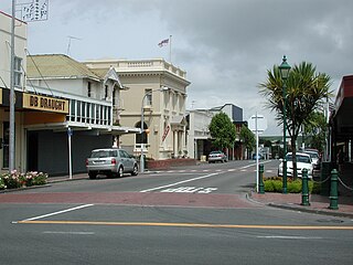
Stratford is the only town in Stratford District, and the seat of the Taranaki region, in New Zealand's North Island. It lies beneath the eastern slopes of Mount Taranaki, approximately halfway between New Plymouth and Hāwera, near the geographic centre of the Taranaki Region. The town has a population of 6,320, making it the 62nd largest urban area in New Zealand, and the fourth largest in Taranaki.

Mount Taranaki is a dormant stratovolcano in the Taranaki region on the west coast of New Zealand's North Island. At 2,518 metres (8,261 ft), it is the second highest mountain in the North Island, after Mount Ruapehu. It has a secondary cone, Fanthams Peak, 1,966 metres (6,450 ft), on its south side.

Inglewood is a town in the Taranaki Region of New Zealand's North Island. It is 16 kilometres (10 mi) southeast of New Plymouth on State Highway 3, close to Mount Taranaki, and sits 200 metres (660 ft) above sea level. The town services a mainly dairy farming region.
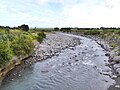
Stony River may refer to the following:
Eltham is a small inland town in South Taranaki, New Zealand, located 50 kilometres (31 mi) south of the city of New Plymouth and southeast of the volcanic cone of Mount Taranaki. Stratford is 11 kilometres (6.8 mi) north, Kaponga 13 km west, and Hāwera is 19 km (12 mi) south. State Highway 3 runs through the town.

Waitara is a town in the northern part of the Taranaki region of the North Island of New Zealand. Waitara is located just off State Highway 3, 15 kilometres (9.3 mi) northeast of New Plymouth.

Ōkato is a small town in rural Taranaki, New Zealand. It is situated about 25 minutes drive around the coast from New Plymouth on State Highway 45. Ōakura is 12 km to the north-east, and Warea is 9 km to the south-west. The place offers popular rocky surfing spots around coastal beaches. The town was established as a military settlement in the 1860s.
Mōkau is a small town on the west coast of New Zealand's North Island, located at the mouth of the Mōkau River on the North Taranaki Bight. Mōkau is in the Waitomo District and Waikato region local government areas, just north of the boundary with the New Plymouth District and the Taranaki Region. Prior to 1989, the town was classed as being in Taranaki, and there is still a feeling that the community of interest is most associated with New Plymouth, 90 km to the southwest. State Highway 3 passes through the town on its route from Te Kūiti to Waitara and, eventually, New Plymouth.
Toko is a small rural settlement 10 kilometres east of Stratford, New Zealand, at the intersection of East Road and Toko Road. It is located on a railway, the Stratford–Okahukura Line, the western portion of which was operated as a branch line known as the Toko Branch prior to the line's completion. The Toko Stream flows through the area to join the Pātea River.

Ōakura is a small township in New Plymouth District, Taranaki, in the western North Island of New Zealand. It is located on State Highway 45, 15 kilometres south-west of New Plymouth. Ōkato is 12 km further south-west. The Oakura River flows past the town and into the North Taranaki Bight. To the south is the Kaitake Range, part of Egmont National Park.
Waipuku is a settlement in inland Taranaki, in the western North Island of New Zealand. It is located between Stratford and Inglewood on State Highway 3.
Urenui is a settlement in northern Taranaki, in the North Island of New Zealand. It is located on State Highway 3 close to the shore of the North Taranaki Bight, 13 kilometres east of Waitara and 6 km south-west of Mimi. The Urenui River flows past the settlement into the North Taranaki Bight.
Tongapōrutu is a settlement in northern Taranaki, in the North Island of New Zealand. It is located on State Highway 3 at the mouth of the Tongaporutu River, 15 kilometres south of Mokau. Tongapōrutu is well known in New Zealand for its 'Three Sisters' rock formations and its Māori petroglyphs carved into cave rock walls. However, both the Māori rock carvings and the 'Three Sisters formations are constantly being eroded by the Tasman Sea.

Uruti is a locality in northern Taranaki, in the North Island of New Zealand. It is located on State Highway 3, north-east of Mimi and south-west of Ahititi. The Uruti Stream meets the Mimi River at this point. The river flows past the settlement into the North Taranaki Bight.
Omata was a New Zealand electorate. It was located in Taranaki and based on the township of Omata. One of the original 24 electorates, it existed from 1853 to 1870.

Stratford District is a territorial authority district in the North Island of New Zealand. The Stratford District Council is headquartered in the only town, Stratford. The district is divided between the Manawatū-Whanganui region and the Taranaki region.
Marchioness was a brigantine built at Waterford, Ireland in 1851 and registered at Melbourne that sailed between Nelson, New Zealand and Melbourne, Australia in the 1850s. It foundered on rocks off the Taranaki coast in 1864 and was lost with no loss of life, having previously grounded twice, once off the coast of Victoria, Australia, and once in Cook Strait.

The Ahukawakawa Swamp is an area of sphagnum bog in Egmont National Park in the Taranaki Region of New Zealand. It was formed approximately 3,500 years ago and is of particular interest to botanists. Over 260 species of higher plant have been recorded there. The area of the swamp is approximately 1 km2.