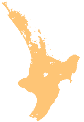
Taranaki is a region in the west of New Zealand's North Island. It is named after its main geographical feature, the stratovolcano Mount Taranaki, also known as Mount Egmont.
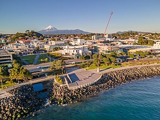
New Plymouth is the major city of the Taranaki region on the west coast of the North Island of New Zealand. It is named after the English city of Plymouth, in Devon, from where the first English settlers to New Plymouth migrated. The New Plymouth District, which includes New Plymouth City and several smaller towns, is the 10th largest district in New Zealand, and has a population of 88,900 – about two-thirds of the total population of the Taranaki Region and 1.7% of New Zealand's population. This includes New Plymouth City (59,600), Waitara (7,550), Inglewood (3,870), Ōakura (1,730), Ōkato (561) and Urenui (429).

Stratford is the only town in Stratford District, and the seat of the Taranaki region, in New Zealand's North Island. It lies beneath the eastern slopes of Mount Taranaki, approximately halfway between New Plymouth and Hāwera, near the geographic centre of the Taranaki Region. The town has a population of 6,320, making it the 62nd largest urban area in New Zealand, and the fourth largest in Taranaki.

Inglewood is a town in the Taranaki Region of New Zealand's North Island. It is 16 kilometres (10 mi) southeast of New Plymouth on State Highway 3, close to Mount Taranaki, and sits 200 metres (660 ft) above sea level. The town services a mainly dairy farming region.

Waitara is a town in the northern part of the Taranaki region of the North Island of New Zealand. Waitara is located just off State Highway 3, 15 kilometres (9.3 mi) northeast of New Plymouth.
The Pai Mārire movement was a syncretic Māori religion founded in Taranaki by the prophet Te Ua Haumēne. It flourished in the North Island from about 1863 to 1874. Pai Mārire incorporated biblical and Māori spiritual elements and promised its followers deliverance from 'pākehā' (British) domination. Although founded with peaceful motives—its name means "Good and Peaceful"—Pai Mārire became known for an extremist form of the religion known to the Europeans as "Hauhau". The rise and spread of the violent expression of Pai Mārire was largely a response to the New Zealand Government's military operations against North Island Māori, which were aimed at exerting European sovereignty and gaining more land for white settlement; historian B.J. Dalton claims that after 1865 Māori in arms were almost invariably termed Hauhau.
Mōkau is a small town on the west coast of New Zealand's North Island, located at the mouth of the Mōkau River on the North Taranaki Bight. Mōkau is in the Waitomo District and Waikato region local government areas, just north of the boundary with the New Plymouth District and the Taranaki Region. Prior to 1989, the town was classed as being in Taranaki, and there is still a feeling that the community of interest is most associated with New Plymouth, 90 km to the southwest. State Highway 3 passes through the town on its route from Te Kūiti to Waitara and, eventually, New Plymouth.
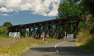
The Stratford–Okahukura Line (SOL) is a secondary railway line in the North Island of New Zealand, between the Marton - New Plymouth Line (MNPL) and the North Island Main Trunk (NIMT) Railway, with 15 intermediate stations. It is 144 km (89 mi) long through difficult country, with 24 tunnels, 91 bridges and a number of sections of 1 in 50 grade. Near Okahukura there is an unusual combined road-rail bridge over the Ongarue River, with the one-lane road carriageway below the single rail track. The line is not currently in service for rail traffic and is under a 30-year lease for a tourist venture. In July 2019 KiwiRail's CEO stated that reopening the line was a priority. Minister of Transport Michael Wood announced the government's 10-year plan for rail investment on 6 May 2021, which specifically stated that plans could include re-opening the Stratford to Okahukura line.
The source of the Waitara River lies in the very steep hill country to the east of Mount Taranaki/Egmont, near Tahora. After proceeding in a southwesterly direction toward Central Taranaki, the river abruptly turns to flow in a northwesterly direction to the Tasman Sea: meeting it at the coastal town of Waitara.

Moturoa is a coastal suburb of New Plymouth, in the western North Island of New Zealand. It is located to the west of the city centre, bordering Port Taranaki and the Sugar Loaf Islands. One of the islands, Moturoa, the largest, shares its name with the suburb.
Tongapōrutu is a settlement in northern Taranaki, in the North Island of New Zealand. It is located on State Highway 3 at the mouth of the Tongaporutu River, 15 kilometres south of Mokau. Tongapōrutu is well known in New Zealand for its 'Three Sisters' rock formations and its Māori petroglyphs carved into cave rock walls. However, both the Māori rock carvings and the 'Three Sisters formations are constantly being eroded by the Tasman Sea.
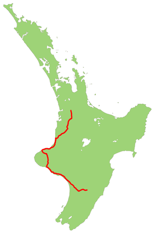
State Highway 3 (SH 3) is one of New Zealand's eight national state highways. It serves the west coast of the country's North Island and forms a link between State Highway 1 and State Highway 2. Distances are measured from north to south.

The Tangahoe River is a river of the Taranaki Region of New Zealand's North Island. It flows generally southwest from its origins in hill country to the east of Lake Rotorangi, reaching the Tasman Sea in the South Taranaki Bight 5 km (3.1 mi) southeast of Hawera.
The Waitara Branch is a 7.245 km long branch line railway in the Taranaki region of New Zealand's North Island. It was built as part of the region's first railway, linking New Plymouth with the closest suitable port, then the river port of Waitara. In 1884 the Breakwater port was opened in New Plymouth, but the line was saved when a (meat) freezing works was opened at Waitara in 1885.

Te Rewa Rewa Bridge is a pedestrian and cycleway bridge across the Waiwhakaiho River at New Plymouth in New Zealand. Its spectacular shape and setting make it a popular landmark.

The Coastal Walkway is a 12.7-kilometre (7.9 mi) long walkway located along the coast of New Plymouth, New Zealand. The walkway stretches from near Port Taranaki, past the central city, through Hickford Park, past Bell Block Beach and to Tiromoana Crescent in Bell Block, north-east of New Plymouth. The walkway runs through a number of bridges, most notably, the Te Rewa Rewa Bridge.

The Waiaua River is a river of the Taranaki Region of New Zealand's North Island. It flows southwest from the slopes of Mount Taranaki to reach the Tasman Sea at Ōpunake.
Tūpare is a former family home in the Arts & Crafts / Tudor style surrounded by a 3.6 ha park / garden in New Plymouth, New Zealand that is now owned and operated by the Taranaki Regional Council as a public park and event venue. It is located above the Waiwhakaiho River.
The Kapuni Branch, formerly known as the Opunake Branch, is a branch railway in North Island, New Zealand. It opened in 1926, and ran 36.4 km across the southern slopes of Mount Taranaki to link the rural town of Ōpunake with the Marton–New Plymouth Line 2 km north of the small rural settlement of Te Roti, equidistant between Eltham and Hāwera. With the decline of rural freight, part of the line was closed in 1976, but the 10.9 km section to Kapuni was retained and upgraded to service traffic to the Kapuni natural gas field.