
The Main North Line between Picton and Christchurch and the Main South Line between Lyttelton and Invercargill, running down the east coast of the South Island of New Zealand, are sometimes together referred to collectively as the South Island Main Trunk Railway (SIMT). Construction of a line running the length of the east coast began in the 1860s and was completed all the way from Picton to Invercargill in 1945; the last sections being on the Main North Line south of Picton. The designation "South Island Main Trunk" originally referred to only that line between Christchurch and Invercargill.
The Waikaka Branch was a branch line railway of the Main South Line that ran through agricultural and gold-mining country in Southland, New Zealand. It was constructed in 1907 and 1908, and was operated by the New Zealand Railways Department until its closure in 1962.
The Tapanui Branch was a railway line located near the border of the regions of Southland and Otago, New Zealand. Although the name suggests that it terminated in Tapanui, its furthest terminus was actually in Edievale. Construction of the line began in 1878 with the first section opened in 1880, and it operated until 1978, when it was destroyed by flooding from the Pomahaka River.
The Main South Line, sometimes referred to as part of the South Island Main Trunk Railway, is a railway line that runs north and south from Lyttelton in New Zealand through Christchurch and along the east coast of the South Island to Invercargill via Dunedin. It is one of the most important railway lines in New Zealand and was one of the first to be built, with construction commencing in the 1860s. At Christchurch, it connects with the Main North Line to Picton, the other part of the South Island Main Trunk.
The Waimate Branch was a branch line railway built in southern Canterbury, New Zealand to link the Main South Line with the town of Waimate, the centre of the surrounding rural area. It opened in 1877 and operated until 1966; for some of this time, it included an extension to Waihao Downs that was known as the Waimate Gorge Branch or Waihao Downs Branch. When the line closed, Waimate received the dubious distinction of being New Zealand's first major town to lose its railway line.

The Foxton Branch was a railway line in New Zealand. It began life as a tramway, reopened as a railway on 27 April 1876, and operated until 18 July 1959. At Himatangi there was a junction with the Sanson Tramway, a line operated by the Manawatu County Council that was never upgraded to the status of a railway.
The Mount Somers Branch, sometimes known as the Springburn Branch, was a branch line railway in the region of Canterbury, New Zealand. The line was built in stages from 1878, reaching Mount Somers in 1885. A further section to Springburn was added in 1889; this closed in 1957, followed by the rest of the line in 1968. A portion has been preserved as the Plains Vintage Railway.
The Kingston Branch was a major railway line in Southland, New Zealand. It formed part of New Zealand's national rail network for over a century: construction began in 1864, Kingston was reached in 1878, and it closed in 1979. For much of its life, it was considered a secondary main line rather than a branch line, and in its earlier years, it was sometimes known as the "Great Northern Railway". Today, the southern portion now forms a part of the Wairio Branch and the northernmost 14 kilometres was used by the Kingston Flyer.
The Fairlie Branch was a branch line railway in southern Canterbury which formed part of New Zealand's national railway network. Construction began in 1874, and at its farthest extent, it terminated just beyond Fairlie in Eversley. Its closure came in 1968, but a portion remains open in Pleasant Point as the Pleasant Point Museum and Railway.
The Eyreton Branch was a branch line railway that formed part of New Zealand's national rail network. Located in the Canterbury region of the South Island, it left the Main North Line in Kaiapoi and was built a mere ten kilometres south of the Oxford Branch. It opened in 1875 and operated until 1954, except for the first portion, which remained open until 1965.

The Oxford Branch was a branch line railway that formed part of New Zealand's national rail network. It was located in the Canterbury region of the South Island, and ran roughly parallel with the Eyreton Branch that was located some ten kilometres south. It opened to Oxford in 1875 and survived until 1959.
The Southbridge Branch was a branch line railway that formed part of New Zealand's national rail network. It was located in the Canterbury region of the South Island and operated from 1875 until 1967. Five kilometres of the line remains open as the Hornby Branch, formerly the Hornby Industrial Line.

The Whitecliffs Branch was an 18.4 kilometres (11.4 mi) long branch line railway that formed part of New Zealand's national rail network in the Canterbury region of the South Island. It was more industrial than the many rural branches on the South Island's east coast whose traffic primarily derived from agriculture, and it operated from 1875 until 1962.
The Ross Branch, officially known as the Hokitika Line since 2011, and previously as the Hokitika Industrial Line, is a branch line railway that forms part of New Zealand's national rail network. It is located in the Westland District of the South Island's West Coast region and opened to Hokitika in 1893. A further extension to Ross operated from 1909 until 1980.

Lyttelton Line is a name sometimes used to refer to the section of the Main South Line in New Zealand's South Island between Lyttelton and Christchurch, and can also be used to refer to the operations on this section. As it has always been part of the Main South Line, this name has never been officially used to refer to the track itself.

The Thames Branch railway line connected Thames, New Zealand, with Hamilton and was originally part of the East Coast Main Trunk railway. Part of the line between Morrinsville and Waitoa remains open and is in use as the Waitoa Branch line, connecting to the Fonterra Dairy Factory at Waitoa.

The Rakaia railway accident at Rakaia, Canterbury, New Zealand on the evening of Saturday, 11 March 1899 occurred when the second of two excursion trains returning from Ashburton to Christchurch ran into the rear of the first at the Rakaia Railway Station, killing four passengers. While due to excessive speed, the accident resulted in overdue improvements by New Zealand Railways to signalling and braking.

The NZR Q class were a pair of 2-4-4T type tank engines built by Rogers Locomotive and Machine Works in New Jersey. They were similar, in appearance, to the earlier K class of the same manufacturer and were purchased by the Rakaia & Ashburton Forks Railway Company for working their newly constructed railway to Methven from Rakaia, which later became the Methven Branch.
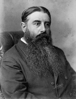
The Vogel Era describes the history of New Zealand between 1873 and 1876, when the country adopted an immigration and public works scheme inaugurated by the colonial treasurer, then premier, Julius Vogel to develop the country and to relieve the slump of the late 1860s; to be financed by borrowing overseas. His "Great Public Works Policy" resulted in a large increase in migrants and provision of many new railways, roads and telegraph lines. The railway system developed from a few lines in three gauges to the start of a national network including the main line from Christchurch to Dunedin, though the narrow "Cape gauge" required later upgrading to increase the restricted height and weight limits.


