The Roxburgh Branch was a branch linerailway built in the Otago region of New Zealand's South Island that formed part of the country's national rail network. Originally known as the Lawrence Branch, it was one of the longest construction projects in New Zealand railway history, beginning in the 1870s and not finished until 1928. The full line was closed in 1968.[1]
The original reason for the line's construction was to provide better transport access to Lawrence, then known as Tuapeka, the site of New Zealand's first significant discovery of gold. Contracts for construction were let by mid-1873, and work on the line was well under way by the next year, with a junction with the Main South Line established at Clarksville. Slips and contractor bankruptcies presented delays, but on 22 January 1877, the line opened to Waitahuna, followed by Lawrence on 2 April 1877, 35.27km from Clarksville.[2]
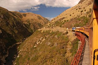
Calls were made to extend the Lawrence Branch further, with some proposals suggesting a route via Roxburgh could serve as the railway to Alexandra and Central Otago in general (instead, the Otago Central Railway followed a more circuitous route via the Taieri and Maniototo).[3] Decades passed until approval was granted to extend the line beyond its Lawrence terminus, with the next section to Big Hill (location of a tunnel between the Bowlers Flat and Craigellachie stations) opened on 4 October 1910. Upon completion of the 434-metre-long (1,424ft) Big Hill tunnel, the line was opened to Beaumont on 15 December 1914, but World War I delayed construction and the next section to Millers Flat was not opened until 16 December 1925. The line was finally completed when the section from Millers Flat to Roxburgh was opened on 18 April 1928.[2] A modified form of the proposal to use Roxburgh as the route to Central Otago resurfaced, proposing that the branch be extended to meet the Central Otago Railway in Alexandra, but this did not come to fruition.
The junction of the Roxburgh Branch with the Main South Line did not always remain in Clarksville. In 1907, an extension of 2.8km was built alongside the Main South Line into Milton to provide for better operation, and until this extension was closed on 19 September 1960, Milton rather than Clarksville acted as the junction.[1]
Stations
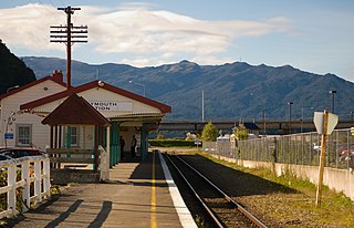
The following stations were located on the Roxburgh Branch (in brackets is the distance from Clarksville):[4]
Six of these stations possessed goods sheds and eight had cattle and sheep yards.
Operation
Like many other branch lines in rural New Zealand, the line typically operated with one mixed train of passengers and freight each way per day. Roxburgh is located in an important stone fruit growing region, and during the appropriate season, special trains would run to carry the large quantities of fruit. The construction of the Roxburgh Dam in the 1950s also provided much traffic for the line. Many extra trains were run during this period but train sizes by today's standards remained constrained due to the steep grades and restrictive locomotive power able to be used on the branch.[2]
Passengers were not plentiful and the line became freight-only from 4 September 1936.[1] This was an attempt to improve the profitability of the line, but it did not work; from the opening of the final section to Roxburgh, the branch always made a working loss, with much traffic lost to road transport operators even before the line reached its greatest length. Steep grades and sharp curves that limited speeds further served to lessen rail's competitiveness.[2]
In 1959–1960, the line carried 9,900 tonnes of freight out and 24,400 tonnes inwards, as well as 16,000 cattle and 51,800 sheep. Losses were increasing, and on 20 June 1961, it was announced that the line would be closed. Public outcry was severe enough that the line received a reprieve, and promises of extra traffic led to an increase in tonnage by 1965. This good news for the line's future did not last, however; by 1967, losses amounted to $100,000 a year and 1 April 1968 was announced as the date the line would close. Again, closure was deferred, but when a deal to export logs did not eventuate and fruit traffic shifted to road, the line's demise became inevitable and a final closure date was set for 1 June 1968.[1][5]
Motive power
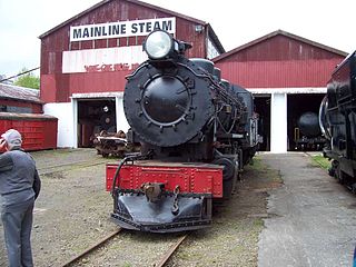
The line was almost exclusively operated by steam locomotives. When the line was still the Lawrence Branch, WD classtank locomotives were based in Lawrence in the early 20th century.[6] When the line became the Roxburgh Branch, the predominant sources of motive power were tender locomotives of the A and AB classes during this period.[2]
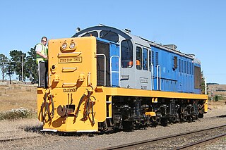
Diesel locomotives were only authorised to operate on the Roxburgh Branch at the time of its closure, to haul trains involved with the dismantling of the line. DJ class engines were the main type of diesel locomotives used.
With closure announced for 1 April 1968, a passenger excursion train, intended to be the last passenger train to Roxburgh, ran on 31 March 1968 and was hauled by AB 795, now preserved on the Kingston Flyer. The Hon Peter Gordon, the Minister of Railways responsible for the final decision to close the branch, drove the train from Lawrence to Roxburgh under New Zealand Railways Department supervision on that day.[7] This train, however, turned out not to be the last as the line was granted a two-month reprieve until 31 May 1968 awaiting a final decision on how the export logs from the vicinity of the then Beaumont State forest were to be transported. The nearby Heriot to Edievale section of the Tapanui Branch, previously closed on 1 January 1968 had its removal also delayed in 1968 for the same reason.[8] It was eventually decided that those logs would be transported by road, thus effectively sealing the fate of both lines.
The last official trains from and to Roxburgh ran on Friday 31 May 1968. The goods train leaving Roxburgh bound for Milton at 10am that morning included three attached passenger carriages. Earlier in the week the carriages had also been attached to a goods train from Millers Flat to Lawrence and back. The cars on the final train carried some 150 children and adults on an excursion organised by the local Teviot Fruitgrowers Association. The carriages exchanged trains at Lawrence, where the up and down trains normally crossed. The speed of the trains carrying the passengers that day was limited to 15 miles per hour throughout the journey due to poor track conditions. On the return journey into Roxburgh that afternoon a flimsy wooden barricade constructed two miles north of Millers Flat, created by locals protesting the closure of the line, was knocked aside by the advancing train, which barely slowed, to the cheers of its passengers. That last official train steamed into the autumn Roxburgh sunset at 4:50pm to the strains of "Now Is the Hour", the Last Post and a swansong of whistles from the engine bearing the words "Last Puffing Engine" on its nose headboard. The Minister of Railways, the Hon J.B. Gordon, was given three cheers in the Roxburgh station and, although not present, was presented anonymously with a large bag of chaff.[9]
Trains continued to run during the first week of June 1968 after closure; one each ran to Lawrence, Beaumont and Roxburgh. The last actual (unofficial service train) goods train from Roxburgh (a cleanup train clearing the stations between Roxburgh and Craig Flat of wagons, as well as the three passenger cars from the official last train) left Roxburgh hauled by an AB steam locomotive on 6 June 1968. This was the last ever steam hauled train on the branch. On the same day an engine and van service hauled by a diesel locomotive of the DJ class ran from Dunedin to Beaumont; the DJ class had been granted running rights on the line that very week. On its return journey that day this diesel-hauled train cleared Beaumont yard and other points south to Lawrence where another train had previously cleared wagons and other equipment out. The DJ locomotive stalled on a steep grade near the Round Hill tunnel as a result of oak leaves falling on the line and the train's relatively large size for the lines steep grades. Sir Arthur Tindall, then judge of the Arbitration Court was travelling in the cab of the following train that day from Roxburgh hauled by the AB. The train he was on came up behind the stalled DJ and its train, struck detonators placed on the line as a warning of the stalled train ahead, giving every one a fright and then after a short while effectively pushed the DJ and its train over the hill at Round Hill. Both trains then continued on their respective journeys to Milton.[10]
Lifting of the Roxburgh Branch commenced on Friday 14 June 1968 with work trains hauled by DJ locomotives subsequently running all the way into Roxburgh. This was the first time DJ locomotives had operated to Roxburgh. By late June 1968 there was considerable removed material at Roxburgh yard ready for loading out by train. Hut accommodation for demolition workers, removal equipment such as bulldozers and a mobile crane on crawlers were transported to Roxburgh by a DJ hauled train on 2 July 1968. A temporary railway Hut compound was established on the Roxburgh station platform for the accommodation of some of the demolition men. Mains power to the Huts, which were individually wired for electricity, was sourced from the electric power lines at Roxburgh station yard. The idea was that these temporary Huts were to be railed down to Millers Flat as the next demolition base just before the mainline rail track had been fully removed from Roxburgh. At the time there was some significant concern reported in the media (and up to Ministerial level) as to why these men had been not able to use the Roxburgh Railway houses, which by now were mostly empty, rather than the expense of establishing the temporary railway workers Hut compound at Roxburgh. However, as explained by Railways at the time, this was impractical as the Huts would be needed anyway as demolition progressed further down the line and so portable accommodation was optimum and in the long run cheaper than furnishing railway houses at Roxburgh for temporary demolition gangs that would be there a few short weeks. By 19 July 1968, the yard track, mainline track past the station platform and turntable at Roxburgh had been removed and cleared out. Men had been recruited from Winter Employment schemes and the mobile crane lifted complete track sets onto flat top wagons for transporting out. During demolition DSA class shunting locomotives worked at the railhead shuttling empty and loaded wagons from and to the nearest exchange siding (the nearest intact station yard) on the branch whilst DJ locomotives periodically cleared out materials removed from that nearest railhead back down the branch to the Main South Line as removal progressed. Track sets were railed to either of Manuka station further down the branch for temporary storage or to Kakapuaka station south of Balclutha on the Main South Line where further Winter Employment Scheme men were employed dismantling these removed track sets. By mid-November 1968 removal was approaching the 40 mile peg, about five miles north of Beaumont (in the Beaumont gorge between Craig Flat and Beaumont). Work then ceased due to a labour shortage as seasonal workers went back to work in local freezing works. A weed spray train ran as far as Beaumont on Monday 11 November 1968, which by then has its all train stop board at 34 miles 37 chains, between Craigellachie and Beaumont (the line from here to the end of rails near the 40 mile peg being worked as an extended Way and Works siding). Through the New Zealand summer of 1969 the line was effectively still complete to the forty mile peg, about five miles past Beaumont up the Beaumont Gorge. Further back up the line, by February 1969 it was reported that the Roxburgh station was derelict without a window left in place and the goods shed was being demolished. Millers Flat station at the time though was still well preserved, to be used as a temporary hotel for a while due to the towns official one burning down.[11]
In April 1969 discussions were had with Pacific Scrap of Auckland with a view to them removing the then remaining 40 miles (64 kilometres) of the branch. Pacific Scrap officials did a velocipede trip up the line for scrap assessment in early May 1969 and a contract was subsequently let to them. Removal of the line recommenced on a six-day-a-week basis from mid-May 1969. The last work train had left Beaumont by early June 1969 hauled by a DJ locomotive. By early July 1969 the rail line had been removed from under the State Highway 8 road overbridge, tunnel and SH8 level crossing of Big Hill. By late July 1969 removal of the line was nearing Lawrence with the last train ever leaving Lawrence by early August 1969. By mid-September 1969, Waitahuna too had seen its last train. By the end of October 1969 the last trains had moved through the Manuka Gorge and its tunnel, the Mount Stuart Tunnel. The final section into Clarksville was lifted on 24 November 1969. The mainline junction points and siding at Clarksville was finally removed on 29 July 1970 and so ended the Roxburgh Branch. Removal of some bridge structures further back up the line, for example, the Waitahuna bridge, continued past this date into 1970, until the local Inspector of Permanent Way was satisfied the line had been demolished to "Railways Department standards".[12]
Subsequently, the Lands and Survey Department disposed of much of the Rail corridor land to adjoining landowners through the early 1970s, although current title searches still reveal in nearly all cases the former route of the line to this day. Looking at Google Earth in 2007 one can easily trace the line through the countryside by zooming in, seeing cuttings, formations and even some railway building structures. For a while, in 1968/1969 there was a suggestion of using the old Big Hill rail tunnel, south of Beaumont, as a bypass over Big Hill for heavy trucks. The one-lane nature of the tunnel and its restrictive height meant that the high stock transporting trucks of the era would be unable to use it so effectively the idea foundered and the tunnel was never used again. However, as described below there is hope that this tunnel may see use again – at least as part of a proposed rail trail. Other parts of the line though were investigated for use also by the Ministry Of Works, the National Road Board and the Tuapeka County Council. This included potentially a suggestion of re-diverting SH8 up the east side of the Clutha River to Millers Flat, general road easements/realignments at old level crossings and the installation of crawler lanes for heavy truck vehicles.[13] Some of these came to fruition but it was not until 2000 that the old formation up the Beaumont Gorge was turned into a minor public road, the Millennium track, which may form part of a future rail trail on the Roxburgh Branch.
The branch today
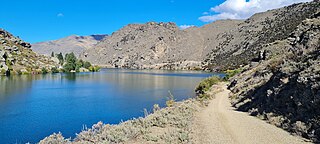
Although remnants of closed railway lines deteriorate and disappear over time, a number of relics from the Roxburgh Branch still exist. The line's formation can often be sighted winding through the countryside and the Mount Stuart Tunnel (also known as the Manuka Creek Tunnel) is still in place and is now a Department of Conservation public walkway of the SH8 road at the western approach to the Manuka Gorge. Round Hill tunnel, which passes directly under the SH8 road at Round Hill, is still in place but the approaches to it are heavily overgrown from both sides. The Big Hill tunnel remains also but is more easily visible from the western portal as the eastern portal is partially obscured by a landslip that fell down from below the SH8 road. In a paddock near a road, Waitahuna retains its goods shed, station building, and even an open-roofed men's toilet. Unfortunately, some other station buildings have not been so lucky; Forsyth's passenger shelter collapsed in 1990, while Lawrence's station was burnt to the ground in a 1981 fire brigade practise. In Rigney, an old boxcar remains at the site of the former yard, with another boxcar located a couple of kilometres from Teviot, while just out of Beaumont, the original rail bridge over the Beaumont River has been in public use since the year 2000 (Previous to this it had been a private bridge with limited access).[14]
Most of the route between Beaumont and to a point near Millers Flat (Minzion) has been made into a public rail trail/track and can now be driven, cycled or walked over. This track is known as the Millennium track and a panel explaining the significance of the rail trail route and other interesting facts is at the site of the old Beaumont railway station at Beaumont just before the SH8 bridge crossing the Clutha river. Several of the old railway bridges alongside the eastern bank of the Clutha River were left in place after the line was lifted through the area in October/November 1968 and later in May 1969 after the Railways Department agreed not to remove the bridges with the then Tuapeka County Council. The trail track through the Beaumont gorge diverts briefly from the old rail corridor to pass over a hill at point known as the Lonely Graves where "Somebody's Darling" lies buried. This burial site was highlighted in Billy Connolly's World Tour of NZ filmed in 2004. The old railway at this point goes around a bluff alongside the Clutha river known as Horseshoe Bend. Past this point heading up to Millers Flat the Millennium trail forms part of the old rail line again until it joins up with up the old Millers Flat - Craig Flat road nearer to the old Minzion station site.
Stockyards remain at the sites of Mount Stuart, Beaumont, Evans Flat, and Millers Flat stations, with the latter two also still in possession of their platforms. Loading banks can be found in Manuka, Evans Flat, Bowlers Creek, and Craigellachie, and a now preserved goods shed is in Teviot (With a Historic Places Trust plaque explaining its significance to the district). A number of relics remain in Roxburgh from its days as a railway terminus; these include a water tank for steam locomotives, the station building converted for farm use, loading banks, a turntable pit, the old rail cement discharge silos at the southern end of the yard (used when cement was transported by rail for the Roxburgh dam construction), and even the concrete stop block that signified the end of the branch.[15]
A proposal has been made to convert most of the branch's former route into a rail trail much like the Otago Central Rail Trail that follows the route of the former Otago Central Railway. Although progress on the proposal has been made, only part of it through the Beaumont Gorge (as described above) and the Mount Stuart Tunnel section has yet to come to fruition.[16]
Related Research Articles
The Cromwell Gorge is a steep gorge cut by the former Clutha River in the Central Otago region of New Zealand's South Island. It winds 19 km (12 mi) between the Dunstan and Cairnmuir Mountains, linking the townships of Cromwell and Clyde. It is one of three substantial river gorges in Central Otago, the others being the Kawarau Gorge to the west of Cromwell, and the Roxburgh Gorge south of Alexandra.
Dunedin Railways is the trading name of Dunedin Railways Limited, an operator of a railway line and tourist trains based at Dunedin Railway Station in the South Island of New Zealand. The company is a council-controlled trading organisation wholly owned by Dunedin City Council through its holding company Dunedin City Holdings Limited.
The Waikaka Branch was a branch line railway of the Main South Line that ran through agricultural and gold-mining country in Southland, New Zealand. It was constructed in 1907 and 1908, and was operated by the New Zealand Railways Department until its closure in 1962.
The Tapanui Branch was a railway line located near the border of the regions of Southland and Otago, New Zealand. Although the name suggests that it terminated in Tapanui, its furthest terminus was actually in Edievale. Construction of the line began in 1878 with the first section opened in 1880, and it operated until 1978, when it was destroyed by flooding from the Pomahaka River.
The Ngapara and Tokarahi Branches were two connected railway branch lines in northern Otago, New Zealand, part of the national rail network. The Ngapara Branch opened in 1877 and almost all of it closed in 1959; the remaining few kilometres, called the Waiareka Industrial Line, were removed in 1997. The Tokarahi Branch branched off the Ngapara Branch. It operated from 1887 until 1930 and was originally known as the Livingstone Branch, though it never progressed beyond Tokarahi to Livingstone. In early 2008 there is a proposal to reinstate the first 4.5 km of the Ngapara Branch.
Beaumont is a small town in inland Otago, in the South Island of New Zealand. It is located on the Clutha River / Mata-Au six kilometres southeast of Raes Junction, between Roxburgh and Balclutha. Beaumont is connected to Milton and Roxburgh by State Highway 8.
The Catlins River Branch was a branch line railway that formed part of New Zealand's national rail network. It ran through the Catlins region in southwestern Otago and was built in sections between 1879 and 1915. It closed in 1971 except for the first four kilometres, which remain open as the Finegand Branch. Along the line was the Hunts Road tunnel, the southernmost tunnel in New Zealand.
The New Zealand DJ class locomotive is a type of diesel-electric locomotive in service on the New Zealand rail network. The class were built by Mitsubishi Heavy Industries and introduced from 1968 to 1969 for the New Zealand Railways Department (NZR) with a modernisation loan from the World Bank to replace steam locomotives in the South Island, where all of the class members worked most of their lives. Nine of the locomotives remain in use, mainly with Dunedin Railways.
The Okaihau Branch, sometimes known as the Kaikohe Branch and rarely the Rangiahua Branch, was a branch line railway that joined the North Auckland Line of the national rail network of New Zealand at Otiria. It was the most northerly line in New Zealand and was intended to run all the way to Kaitaia. It opened to Ōkaihau in 1923 and closed in 1987.
The BA class was a class of steam locomotive built by the New Zealand Railways Department (NZR) for use on New Zealand's national rail network. The first BA entered service in November 1911, with the last of the 11 class members introduced on 14 May 1913.
The Railway Enthusiasts Society Incorporated is a New Zealand railway enthusiast society formed on 17 July 1958. RES formed the Glenbrook Vintage Railway (GVR) in 1968, with GVR now forming a separate charitable trust.
The Midland line is a 212 km section of railway between Rolleston and Greymouth in the South Island of New Zealand. The line features five major bridges, five viaducts and 17 tunnels, the longest of which is the Otira tunnel. It is the route of the popular TranzAlpine passenger train.
The Otago Central Railway (OCR) or in later years Otago Central Branch Railway, now often referred to as the Taieri Gorge Railway, was a secondary railway line in Central Otago, in the South Island of New Zealand.
Waitahuna is a small rural hamlet in the Otago region of New Zealand's South Island. It is 10 kilometres (6.2 mi) from Lawrence.
The Waiau Branch was a branch line railway in the northern Canterbury region of New Zealand's South Island. Known as the Great Northern Railway for its first few decades of life, the Waiau Branch was seen as part of a main line north but was ultimately superseded by a coastal route. Opened in stages from 1882 to 1919, the line closed in 1978 but a portion has been retained as the Weka Pass Railway.
The Ross Branch, officially known as the Hokitika Line since 2011, and previously as the Hokitika Industrial Line, is a branch line railway that forms part of New Zealand's national rail network. It is located in the Westland District of the South Island's West Coast region and opened to Hokitika in 1893. A further extension to Ross operated from 1 April 1909 until 24 November 1980.
The Seddonville Branch, later truncated as the Ngākawau Branch, is a branch line railway in the West Coast region of New Zealand's South Island. Construction began in 1874 and it reached its terminus at the Mokihinui Mine just beyond Seddonville in 1895. In 1981 it was closed past Ngākawau and effectively became an extension of the Stillwater–Westport Line, since formalised as the Stillwater–Ngākawau Line.
State Highway 8 is one of New Zealand's eight national highways. It forms an anticlockwise loop through the southern scenic regions of the Mackenzie Basin and Central Otago, starting and terminating in junctions with State Highway 1. Distances are measured from north to south.
Manuka Creek is a locality in Otago, New Zealand, on the banks of the Manuka Stream, a tributary of the Tokomairiro River. It is located a short distance to the east of State Highway 8. The Manuka Railway Station on the Roxburgh Branch line was located by it. Herbert Deveril and Albert Percy Godber photographed the railway station. The creek was once a busy site for gold mining.
Mount Stuart is a rural locality and settlement in South Otago, New Zealand. It is located between Manuka Creek and Glenore on State Highway 8, approximately halfway between Milton and Waitahuna. It sits close to the upper reaches of the west branch of the Tokomairiro River, just below the confluence with the Manuka Stream.
↑ J. A. Dangerfield and G. W. Emerson, Over the Garden Wall: Story of the Otago Central Railway (Dunedin: Otago Railway and Locomotive Society, 1995), 9.
↑ Otago Daily Times Article, "Last Train Runs To Edievale Despite Chance Of Reprieve", 29 December 1967,
↑ Staff Reporter, Otago Daily Times Article, "Roxburgh's Last Train", 1 June 1968,
↑ F.W.G.Miller, The Story Of The Kingston Flyer,17.
↑ New Zealand Government Railways Files on Roxburgh Branch - General Manager files sourced from National Archives New Zealand, Wellington 2007, New Zealand,
↑ New Zealand Governments Railways - District Engineers Dunedin, File on Pacific Scrap Contract - Demolition Roxburgh Branch - April 1969 - June 1970,
↑ Otago Daily Times, "Old Line's Potential Studied",25 June 1968,
↑ John Gibb, "Rail Trail Tourism Boost on Track", Otago Daily Times, 24 October 2006.
Bibliography
Churchman, Geoffrey B; Hurst, Tony (2001) [1990, 1991]. The Railways of New Zealand: A Journey through History (Seconded.). Transpress New Zealand. ISBN0-908876-20-3.
Cowan, W. J., (2010) Rails to Roxburgh, 256 pages.
Leitch, David; Scott, Brian (1995). Exploring New Zealand's Ghost Railways (1998ed.). Wellington: Grantham House. ISBN1-86934-048-5.
Mulligan, Barbara (2000). New Zealand Rail Trails: A Guide to 42 Ghost Lines. Wellington: Grantham House Publishing. pp.175–187. ISBN978-1-86934-126-8.
This page is based on this Wikipedia article Text is available under the CC BY-SA 4.0 license; additional terms may apply. Images, videos and audio are available under their respective licenses.