Strath Taieri

Last updated
Strath Taieri with Rock and Pillar Range Strath Taieri with Rock and Pillar Range.jpg
Strath Taieri with Rock and Pillar Range

The Strath Taieri (sometimes spelt Strath-Taieri) is a large glacial valley and river plateau in New Zealand's South Island. It is surrounded by the rugged hill ranges to the north and west of Otago Harbour. Since 1989 it has been part of the city of Dunedin. The small town of Middlemarch is located at its southern end.

Contents

The name is a hybrid word, from Strath (anglicised Irish and Scots Gaelic srath), meaning a broad river valley, and the Māori name Taieri pronunciation (alternative spelling Taiari) of the river which runs through it.

History

Early history

There is evidence that moa hunters (1300-1500) were once active on the Strath Taieri, the Taieri Gorge, at Deep Stream and Rocklands on the adjacent plateau to the south. [1] A Māori route from the coast to the interior lay along the valley[ citation needed ]. Activity during the Classic period (1500–1642) is attested by a cave discovered in 1949 with its entrance blocked, containing the bodies of a Māori woman and child. [2] It is not clear if they were trapped deliberately or accidentally. This corresponds with other sites in the area containing rock shelters with mostly domestic articles, wooden bowls, material for garments and gear for hunting weka or fishing. [3] Charles Kettle saw the area from the top of Maungatua in 1847 and was impressed by the land's pastoral potential.

Strath Taieri and its surrounding district lay beyond the limit of the coastal Otago Block which Kettle was surveying but, following the Otago Association's settlement on that land in 1848, horizons became broader. Kettle was one of the first Europeans known to have visited the Strath Taieri when he led an exploration party up the "strath" in February 1851. [4] The Otago Provincial government was established in 1852, whose territory included the region.

It seems Duncan Stewart, his wife and their children were living on the site of what was later the Barewood homestead, on the Barewood run, by late 1853 or early 1854. [5] John Sutton was granted the Barewood Run in 1854 before it was surveyed. Between 1857 and 1859 much of the land in and around Strath Taieri was taken up by pastoralists on lease from the Crown.

One of these leaseholds, Cottesbrook, became the centre of several sheep stations put together by the Tasmanian Gellibrand family. A group of buildings, including a homestead, office, cottage, cook house, butcher's shop and large shearing shed were all built from the local stone. They remain, fine examples of masonry and distinctively Australasian design. [6] A number of the early European settlers came from Tasmania.

The gold rush and its aftermath

From 1861, the Otago gold rushes saw the development of a stagecoach route, the Dunstan Trail leaving the coastal Taieri Plain near Outram advancing north and west across the plateau south of Strath Taieri proper, through Clark's Junction and on over the Rock and Pillar Range to the Maniototo. A new road north through Strath Taieri was proposed in 1863. In 1864, gold-bearing ground was reported at Hyde at the head of Strath Taieri and now the northern limit of Dunedin. Briefly, there were two thousand people there. Goldfields to the east and north saw the 'middle Taieri valley', as Strath Taieri was sometimes called, surrounded by prospering districts.

Edward Wingfield Humphreys (1841–1892) is credited with naming the valley 'Strath Taieri'. Alice Humphreys (née Hawdon, 1848–1934) moved to her husband's property in the "strath" soon after their marriage in 1869. She is credited with calling the private township laid out on their property 'Middlemarch' after George Eliot's novel. [7] However, this origin of the name has been disputed. From whatever source it got its name, the private township of Middlemarch on Humphrey's property of Garthmyl had been surveyed on land adjoining the projected railway and several sections were already sold by 6 November 1880. [8] A stone house was built and occupied by Mr. Kirk and his family by the winter of 1881. [9] By 1891, there was a hotel, eight houses, two blacksmith shops, two stores, a school and twenty tents occupied by workers building the railway.

Following the abolition of the New Zealand provinces in 1876 the Taieri County was formed, whose Deep Stream Riding included Strath Taieri. The county improved the road traversing the plateau from the Taieri Plain, building a bridge over Deep Stream in 1880, a suspension bridge over the Taieri River at Sutton in 1885, and the same year another over the Taieri linking Middlemarch with the Cottesbrook station. The Sutton Stream, south of the township, was bridged in 1884. There was a long pause before the 'centre road', now state highway 87, was extended north to Hyde and the Maniototo.

Construction of the Otago Central Railway from the South Island's main trunk line, which lay along the coast, began in 1879. Its route was projected to cross the Taieri Plain and follow the Taieri Gorge upstream to Strath Taieri, which it would then traverse from south to north as the main route to Central Otago. The gorge presented formidable obstacles, to which the existing bridges and tunnels are now picturesque testimony. The line reached Middlemarch in April 1891, spurring the township's development. It was extended to Hyde on 16 July 1894, where it had a similar effect. The line's eventual terminus was Cromwell in the Upper Clutha catchment, but it did not arrive there until 1921. [10]

Schist is prominent in the hills surrounding Strath Taieri Sheep grazing in dry landscape with schist rocks.jpg
Schist is prominent in the hills surrounding Strath Taieri

To develop Middlemarch the March Creek had been diverted and for many years the township was regularly flooded until channel work on the creek ameliorated the problem. A Presbyterian preacher covered the Strath Taieri district in 1886. Anglican and Roman Catholic churches were built in 1901 and a handsome church of the local schist stone was completed for the Presbyterians in 1906.

Twentieth century and beyond

Gold mining in nearby areas such as Macraes Flat and Nenthorn buoyed up the development of the Strath Taieri and its townships, but that stalled in the twentieth century. In the 1880s, rabbits became a plague, and it was only by strenuous efforts this was contained by the 1940s. Runs were broken up for closer settlement in 1894 and later, but the valley remained thinly populated. In 1914, there was a move to have the Strath Taieri Riding transferred to the Maniototo County, which was unsuccessful. In the 1930s, attempts to get a water supply for Middlemarch were also unsuccessful. However, an electricity supply to Middlemarch was made operative on 28 July 1939. [11]

On 4 June 1943, the derailment of the Dunedin Cromwell Express on the outskirts of Hyde cost twenty-one lives. Because the accident was attributed to the negligence of the engine driver, the government became liable for more than £200,000 in compensation. The modern equivalent would be several million dollars. Postwar development was slow and while farm production increased, the population expanded only a little and latterly declined.

As the 20th century advanced, this large and apparently empty country maintained the character and atmosphere of a pioneering district. Middlemarch could seem to visitors like a set for 'High Noon'. The plateau country to the south, with its fantastic rock formations, tors, heightens the impression of antiquity and otherworldliness which inspired artistic responses. Until 1948, Antimony was mined at Hindon. [12] [13]

The celebrated New Zealand painter Colin McCahon as a schoolboy in 1936, had what he later described as a 'vision' looking westward from a point on the coastal hills over the Taieri Plain apparently to the plateau country south of the Strath Taieri proper. He later said his art had been an attempt to communicate this vision. He described it as seeing a landscape 'standing far from the sun of Egypt in the Otago cold.' He called it a 'landscape of splendour and order and peace', which he conceived as a pre-Biblical place. [14] In 1945, his younger and also celebrated Otago contemporary, the poet James K. Baxter, wrote 'Upon the upland road/Ride easy, stranger:/Surrender to the sky/Your heart of anger.' The lines certainly capture the effect on some people of the experience of crossing the plateau, approaching the Strath Taieri by road from the south. [15]

That landscape became greener in the 1960s and 1970s as native tussock was converted to European pasture, a process protested in the works of the artist Marilynn Webb. But the postwar prosperity of farming ended in the 1970s. In October 1977, the Taieri County was merged with its northern neighbour, Waikouaiti County, thus Strath Taieri became part of the new The Silverpeaks County surrounding Dunedin and its boroughs in an inland arc. Rural recession intensified and in 1989 The Silverpeaks County was merged into a new, much enlarged, City of Dunedin. In 1990, the Central Otago Railway was closed and the line from Clyde back to Middlemarch soon uplifted. Nevertheless, a tourist train service was being operated from Dunedin to Strath Taieri by way of the Taieri Gorge on the remaining part of the line. Since 1991 this has been run by the Taieri Gorge Railway Limited owned by the Dunedin City Council. In 1993, the course of the track further inland was opened as the Otago Central Rail Trail for hikers and cyclists, by the Department of Conservation. Both have proved successful in attracting visitors.

State Highway 87 entering the southern end of Strath Taieri SH87 south of Sutton.jpg
State Highway 87 entering the southern end of Strath Taieri

As a farming district, strategically located but isolated by geographical barriers, Strath Taieri's development turned on changes in farming and transport until the late 20th century. While the closure of the through railway saw the end of that means of moving heavy goods between the coast and the interior, the completion of the tar sealing of State Highway 87, in 1996, was the effective provision of another. With the growth of tourism, much of it motor-vehicle-based, this, with the rail trail and tourist rail services, has added a new element to the mix.

The rural, pioneering atmosphere of the district was perhaps responsible for the unexpected success of its bachelor dances, recently promoted ostensibly to find partners for its single men. That, and the emergence of New Zealand's iconic Southern Man may have led to the event's attracting visitors from around the country and overseas. Apparently, few marriages have resulted, but Strath Taieri has become known to many more people.

Demographics

The statistical area of Strath Taieri, which includes Middlemarch, covers 2,115.02 km2 (816.61 sq mi) [16] and had an estimated population of 700 as of June 2023, [17] with a population density of 0.33 people per km2.

Historical population
YearPop.±% p.a.
2006714    
2013714+0.00%
2018666−1.38%
Source: [18]

Strath Taieri had a population of 666 at the 2018 New Zealand census, a decrease of 48 people (−6.7%) since the 2013 census, and a decrease of 48 people (−6.7%) since the 2006 census. There were 267 households, comprising 369 males and 300 females, giving a sex ratio of 1.23 males per female. The median age was 43.0 years (compared with 37.4 years nationally), with 135 people (20.3%) aged under 15 years, 84 (12.6%) aged 15 to 29, 366 (55.0%) aged 30 to 64, and 84 (12.6%) aged 65 or older.

Ethnicities were 95.5% European/Pākehā, 9.9% Māori, 0.5% Pasifika, and 1.8% other ethnicities. People may identify with more than one ethnicity.

The percentage of people born overseas was 6.8, compared with 27.1% nationally.

Although some people chose not to answer the census's question about religious affiliation, 56.3% had no religion, and 36.5% were Christian.

Of those at least 15 years old, 84 (15.8%) people had a bachelor's or higher degree, and 90 (16.9%) people had no formal qualifications. The median income was $34,700, compared with $31,800 nationally. 69 people (13.0%) earned over $70,000 compared to 17.2% nationally. The employment status of those at least 15 was that 297 (55.9%) people were employed full-time, 93 (17.5%) were part-time, and 18 (3.4%) were unemployed. [18]

Education

In 2021, there is one primary school in the Strath Taieri District, at Middlemarch. There were several schools in earlier times.

Notes

  1. Hamel, 2001, fig 2 p.16.
  2. Thompson, 1949, pp.6-7.
  3. Hamel, 2001, fig 1. p.10 & p.80.
  4. McLintock, 1949, p.332.
  5. Thompson, 1949, p.10.
  6. Thompson, 1949 p.23; illustrated Porter, 1983 p.220.
  7. Thomson, 1998, p.240.
  8. Thompson, 1949, pp.44-5.
  9. Thompson, 1949, p.105.
  10. Thompson, 1949, pp.95-7.
  11. Thompson, 1949, p.141.
  12. "Roméite Group from Mt Stoker Antimony Mine, Hindon, Dunedin City, Otago Region, New Zealand".
  13. "Mt Stoker Antimony Mine, Hindon, Dunedin City, Otago Region, New Zealand".
  14. McCahon, 1966, pp.363-4.
  15. Baxter in Weir(ed),1981, p.34.
  16. "ArcGIS Web Application". statsnz.maps.arcgis.com. Retrieved 25 December 2021.
  17. "Population estimate tables - NZ.Stat". Statistics New Zealand . Retrieved 25 October 2023.
  18. 1 2 "Statistical area 1 dataset for 2018 Census". Statistics New Zealand. March 2020. Strath Taieri (349000). 2018 Census place summary: Strath Taieri

Related Research Articles

<span class="mw-page-title-main">Otago</span> Region of New Zealand

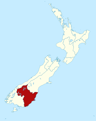
Otago is a region of New Zealand located in the southern half of the South Island administered by the Otago Regional Council. It has an area of approximately 32,000 square kilometres (12,000 sq mi), making it the country's second largest local government region. Its population was 254,600 in June 2023.

<span class="mw-page-title-main">Middlemarch, New Zealand</span> Human settlement in Dunedin City, Otago Region, New Zealand

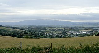
Middlemarch is a small town in the Otago region of New Zealand's South Island. It lies at the foot of the Rock and Pillar Range of hills in the broad Strath-Taieri valley, through which flows the middle reaches of the Taieri River. Since local government reorganisation in the late 1980s, Middlemarch and much of the Strath-Taieri has been administered as part of Dunedin city, the centre of which lies some 80 km to the southeast. Middlemarch is part of the Taieri electorate, and is currently represented in parliament by Ingrid Leary. Middlemarch has reticulated sewerage but no reticulated water supply. A description of 1903, that "[T]he summer seasons are warm, but not enervating, and the winters cold, but dry" is still true today.

<span class="mw-page-title-main">Dunedin</span> City in Otago, New Zealand

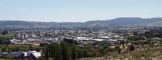
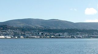
Dunedin is the second-largest city in the South Island of New Zealand, and the principal city of the Otago region. Its name comes from Dùn Èideann, the Scottish Gaelic name for Edinburgh, the capital of Scotland. The city has a rich Māori, Scottish, and Chinese heritage.

<span class="mw-page-title-main">Mosgiel</span> Town in Otago, New Zealand

Mosgiel is an urban satellite of Dunedin in Otago, New Zealand, fifteen kilometres west of the city's centre. Since the re-organisation of New Zealand local government in 1989 it has been inside the Dunedin City Council area. Mosgiel has a population of approximately 14,800 as of June 2023. A nickname for Mosgiel is "The pearl of the plain". Its low-lying nature does pose problems, making it prone to flooding after heavy rains. Mosgiel takes its name from Mossgiel Farm, Ayrshire, the farm of the poet Robert Burns, the uncle of the co-founder in 1848 of the Otago settlement, the Reverend Thomas Burns.

<span class="mw-page-title-main">Taieri River</span> River in New Zealand

The Taieri River is the fourth-longest river in New Zealand and is in Otago in the South Island. Rising in the Lammerlaw Range, it initially flows north, then east around the Rock and Pillar range before turning southeast, reaching the sea 30 kilometres (19 mi) south of Dunedin.

<span class="mw-page-title-main">Taieri Plain</span> Plain in New Zealand

The Taieri Plain is an area of fertile agricultural land to the southwest of Dunedin, in Otago, New Zealand. The plain covers an area of some 300 square kilometres, with a maximum extent of 30 kilometres. It is not to be confused with Strath Taieri, a second plain of the Taieri River, 40kms to the north beyond Mount Ross.

<span class="mw-page-title-main">The Maniototo</span>

The Maniototo Plain, usually simply known as The Maniototo, is an elevated inland region in Otago, New Zealand. The region roughly surrounds the upper reaches of the Taieri River and the Manuherikia River. It is bounded by the Kakanui Range to the north and the Rock and Pillar Range to the southeast. It has a harsh, dry climate, ranging from over 30 °C in mid-summer to -15 °C in mid-winter.

<span class="mw-page-title-main">Dunedin Railways</span>

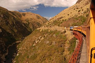
Dunedin Railways is the trading name of Dunedin Railways Limited, an operator of a railway line and tourist trains based at Dunedin Railway Station in the South Island of New Zealand. The company is a council-controlled trading organisation wholly owned by Dunedin City Council through its holding company Dunedin City Holdings Limited.

<span class="mw-page-title-main">Ranfurly, New Zealand</span> Settlement in Otago, New Zealand

Ranfurly is a town in the Central Otago District of Otago, New Zealand. Located 110 kilometres north of Dunedin, it lies in the dry rough plain of Maniototo at a moderately high altitude close to a small tributary of the Taieri River. It operates as a service town for the local farming community. The town was formerly known as Eweburn, one of the "farmyard" names bestowed by former Otago Chief Surveyor John Turnbull Thomson on many small streams and locations in the district. The modern name honours the Fifth Earl of Ranfurly, who served as Governor of New Zealand (1897–1904) at the time of the extension of the Otago Central Railway to the area. Ranfurly is well known for its Art Deco buildings, such as its hotel and the milk bar.

<span class="mw-page-title-main">The Silverpeaks</span>

The Silverpeaks is an area of rough forest and tussock and scrub covered hill country inland and to the northwest of Dunedin, New Zealand. The area is largely uninhabited; the main indication of human activity is the Taieri Gorge Railway, which preserves the route of the former Otago Central Railway that runs along the steep-sided valley of the Taieri River. Much of the area lies within the Silverpeaks Scenic Reserve.

<span class="mw-page-title-main">Otago Central Rail Trail</span>

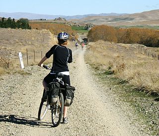
The Otago Central Rail Trail is a 150-kilometre walking, cycling and horse riding track in the South Island of New Zealand. A pioneering project for New Zealand, the successful rail trail joined the New Zealand Cycle Trail umbrella organisation in 2012, having been one of the inspirations for it.

<span class="mw-page-title-main">Taieri Gorge</span>

The Taieri Gorge is located on the Taieri River, in the South Island of New Zealand. It is a deep canyon carved by the Taieri River on the middle stage of its journey from Central Otago to the Pacific Ocean, between the high plateau of the Maniototo and the coastal Taieri Plains. The gorge is over 40 kilometres (25 mi) long and stretches from near Pukerangi to southeast of Outram. A walking track leads from Outram into the southern end of the gorge.

<span class="mw-page-title-main">Wedderburn, New Zealand</span> Locality in New Zealand

Wedderburn is a community in Central Otago, New Zealand. It is located 15 kilometres northwest of Ranfurly, and was at one time close to the centre of a thriving gold and coal mining area. The name of Wedderburn was given to the area by John Turnbull Thomson, and is one of the names in his infamous "Thomson's Barnyard", wedder being Northumbrian dialect form of the word wether, meaning a castrated sheep.

Paerau is a small settlement in inland Central Otago in New Zealand's South Island. It is located in the Strath Taieri, the upper valley of the Taieri River, at the foot of the Rock and Pillar Range. "Paerau" is a Māori-language name meaning "one hundred ridges".
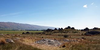
<span class="mw-page-title-main">Otago Central Railway</span> Branch railway line in Otago, New Zealand

The Otago Central Railway (OCR) or in later years Otago Central Branch Railway, now often referred to as the Taieri Gorge Railway, was a secondary railway line in Central Otago, in the South Island of New Zealand.

<span class="mw-page-title-main">Hyde, New Zealand</span> Town in Otago, New Zealand

Hyde is a locality in Otago, New Zealand, located in the Strath-Taieri. It is close to the northern end of the Rock and Pillar Range on State Highway 87 between Middlemarch and Ranfurly. Hyde is best known as the site of the Hyde railway disaster of 4 June 1943, in which 21 people were killed when an express train on the Otago Central Railway derailed at high speed in a cutting near the town. At the time, it was the worst railway accident in New Zealand's history; it has only been passed by the Tangiwai disaster of 24 December 1953, which claimed the lives of 151 people. The site of the Hyde disaster can now be walked as part of the Otago Central Rail Trail and a monument, a 2.5 m high cairn, stands as a memorial to the victims.

<span class="mw-page-title-main">Wingatui</span> Settlement in New Zealand

Wingatui is a small settlement almost 15 kilometres west of Dunedin, and two kilometres east of Mosgiel. It has become a suburb of Mosgiel, but continues to maintain its own unique identity and heritage.

<span class="mw-page-title-main">State Highway 87 (New Zealand)</span> Road in New Zealand

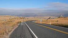
State Highway 87 (SH 87) is a state highway in New Zealand servicing the Taieri Plains and the Strath-Taieri Valley in Otago, connecting Mosgiel to Kyeburn on the eastern flank of the Maniototo Plains.

<span class="mw-page-title-main">Hindon, New Zealand</span> Small settlement in inland Otago, in the South Island of New Zealand

Hindon is a small settlement in inland Otago, in the South Island of New Zealand. It is located 24 kilometres (15 mi) northwest of Dunedin in the Silverpeaks Range, close to the edge of the Strath Taieri. The Taieri Gorge Railway runs through Hindon on its way between Dunedin and Middlemarch.

<span class="mw-page-title-main">Deep Stream</span> River in Otago, New Zealand

Deep Stream is a tributary of the Taieri River in Otago, New Zealand. The stream runs generally eastwards for some 70 kilometres from its source on the slopes of Lammerlaw in the Lammerlaw Range, reaching the Taieri River near Hindon in the Taieri Gorge.

References

45°24′20.7″S170°11′0.51″E / 45.405750°S 170.1834750°E / -45.405750; 170.1834750