
Dunedin is the second-largest city in the South Island of New Zealand, and the principal city of the Otago region. Its name comes from Dùn Èideann, the Scottish Gaelic name for Edinburgh, the capital of Scotland. The city has a rich Māori, Scottish, and Chinese heritage.
Dunedin is a city of 134,600 people in the South Island of New Zealand. The principal suburbs of Dunedin are as follows. Inner and outer suburbs are ordered by location, clockwise from the city centre, starting due north:
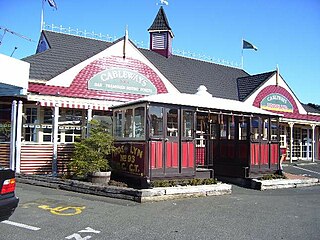
The Dunedin cable tramway system was a group of cable tramway lines in the New Zealand city of Dunedin. It is significant as Dunedin was the second city in the world to adopt the cable car.

George Street is the main street of Dunedin, the second largest city in the South Island of New Zealand. It runs for two and a half kilometres north-northeast from The Octagon in the city centre to the foot of Pine Hill. It is straight and undulates gently as it skirts the edge of the hills to its northwest. South of The Octagon, Princes Street continues the line of George Street south-southwest for two kilometres.

Princes Street is a major street in Dunedin, the second largest city in the South Island of New Zealand. It runs south-southwest for two kilometres from The Octagon in the city centre to the Oval sports ground, close to the city's Southern Cemetery. North of The Octagon, George Street continues the line of Princes Street north-northeast for two and a half kilometres. Princes Street is straight but undulating, skirting the edge of the City Rise to its northwest. The part of the street immediately below The Octagon is the steepest section, as the road traverses an old cutting through Bell Hill.

Lawyers Head is a prominent landmark on the coast of Otago, New Zealand. Located within the city of Dunedin, this rocky headland juts into the Pacific Ocean at the eastern end of the city's main beach, Saint Kilda Beach. It is named for the likeness of the cliff face to the profile of a lawyer in traditional legal wig.

Logan Park is a sporting venue in the city of Dunedin, New Zealand. It lies on land reclaimed from the former Lake Logan.
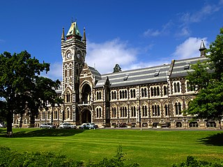
Dunedin North, also known as North Dunedin, is a major inner suburb of the New Zealand city of Dunedin, located 1.5 kilometres (0.93 mi) northeast of the city centre. It contains many of the city's major institutions, including the city's university, polytechnic, main hospital, and largest museum. Dunedin North's 2001 population was 7,047, including the university area.

Caversham is one of the older suburbs of the city of Dunedin, in New Zealand's South Island. It is sited at the western edge of the city's central plain at the mouth of the steep Caversham Valley, which rises to the saddle of Lookout Point. Major road and rail routes south lie nearby; the South Island Main Trunk railway runs through the suburb, and a bypass skirts its main retail area, connecting Dunedin's one-way street system with the Dunedin Southern Motorway. The suburb is linked by several bus routes to its neighbouring suburbs and central Dunedin.
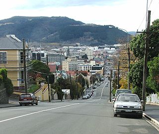
City Rise is an inner suburb of the New Zealand city of Dunedin. One of the city's older suburbs, it is, as its name suggests, centred on the slopes which lie close to the city centre, particularly those closest to the city's original heart of The Exchange. Extensive views across the central city can be gained from much of City Rise.

Mornington is a suburb of the city of Dunedin, in the South Island of New Zealand. It is situated on hilly slopes 2 kilometres (1.2 mi) to the west of the city centre, the slopes forming part of a ridge which surrounds the heart of the city.

Māori Hill is a residential suburb of the New Zealand city of Dunedin. It is located at the northern end of the ridge which runs in a crescent around the central city's western edge, 2 kilometres (1.2 mi) to the northwest of the city centre, immediately above and within the Town Belt. It is connected to Dunedin North, which lies to the east, via Drivers Road, the suburbs of Roslyn and Kaikorai to the southwest via Highgate, and the suburb of Wakari to the northwest via Balmacewen Road.

Kensington is a small suburb of the New Zealand city of Dunedin, nestled to the south of a hilly spur between the central city and the major suburb of South Dunedin, some 2.4 kilometres (1.5 mi) to the south of the city centre. The suburb was named for the leafy London suburb, possibly by John Hyde Harris, who subdivided the area in the 1860s.
Maryhill is a residential suburb of the New Zealand city of Dunedin. It is located on a ridge to the southwest of the central city between the suburbs of Mornington, Kenmure, and Caversham. The smaller suburb of Balaclava lies immediately to its west. Maryhill is believed to take its name from a district in the city of Glasgow in Scotland, where many of the early settlers of the suburb originated. In this regard it is unusual among Dunedin suburbs, many of which are named for suburbs of Edinburgh - Maryhill and the nearby Little Paisley are the only suburbs named for Glaswegian locations, and the latter is an old name rarely used today. A second theory is that Maryhill was named in honour of Mary, the wife of early Dunedin settler John Bathgate.

Roslyn is a major residential and retail suburb of the New Zealand city of Dunedin. It is located 150 metres (490 ft) above the city centre on the ridge which runs in a crescent around the central city's western edge. It is 2.5 kilometres (1.6 mi) to the northwest of the city centre, immediately above the Town Belt.

Leith Valley is a suburb, valley, and general area of the New Zealand city of Dunedin, located to the northwest of the city centre. To differentiate the name of the valley from that of the suburb, the former is usually referred to as the Leith Valley, the latter simply as Leith Valley.

The Caledonian Ground, often simply known as "The Caley", is a major sports venue in the New Zealand city of Dunedin. It is primarily used for football (soccer) and athletics, and has a capacity of 7,500.
The Kensington Oval, formerly known as the South Dunedin Recreation Ground, is a park and sports ground in Kensington, Dunedin, New Zealand. It is also known as just The Oval, although this name has become less common in recent years due to the potential confusion with the University Oval in the north of the city.

The Warehouse Precinct is an urban area of the New Zealand city of Dunedin. Sited on reclaimed land at the northernmost tip of the Southern Endowment, it lies between 1 and 2 kilometres south of The Octagon, the city's centre.

Queens Gardens is a roughly triangular area of trees and lawn in central Dunedin, New Zealand.


