
Thomas Bracken was an Irish-born New Zealand poet, journalist and politician. He wrote "God Defend New Zealand", one of the two national anthems of New Zealand, and was the first person to publish the phrase "God's Own Country" as applied to New Zealand. He also won the Otago Caledonian Society's prize for poetry.

Dunedin is the second-largest city in the South Island of New Zealand, and the principal city of the Otago region. Its name comes from Dùn Èideann, the Scottish Gaelic name for Edinburgh, the capital of Scotland. The city has a rich Scottish, Chinese and Māori heritage.

Larnach Castle is a mock castle on the ridge of the Otago Peninsula within the limits of the city of Dunedin, New Zealand, close to the small settlement of Pukehiki. It is one of a few houses of this scale in New Zealand. The house was built by the prominent entrepreneur and politician, William Larnach. Since 1967, the castle has been privately owned by the Barker family, and opened as a tourist attraction, as "New Zealand's only castle".

The ruins of Cargill's Castle stand on a promontory overlooking the Pacific Ocean in New Zealand's southern city of Dunedin. It is one of about ten castles in New Zealand, the other one in Otago being nearby Larnach Castle. More a castle in name than in fact, this Italianate mansion was built for Edward Cargill, eighth child of city founder William Cargill, in the late 19th century, who called it The Cliffs. Designed by the young architect Francis Petre, and built in concrete by Harry Lyders at a cost of £14,000, it was completed in 1877. Several kilometres south of the castle is Tunnel Beach, so named because this quiet beach is only accessible through a steeply sloping tunnel cut into the 60 metres (200 ft) high cliffs by the Cargill family. It is also very likely that Petre was the supervisor of the construction of the tunnel. While designing the house, Petre fell in love with Cargill's daughter Margaret. After a difficult courtship the couple were eventually permitted to marry, the wedding taking place in the villa's principal salon on 1 March 1881.
Dunedin is a city of 130,400 people in the South Island of New Zealand. The principal suburbs of Dunedin are as follows. Inner and outer suburbs are ordered by location, clockwise from the city centre, starting due north:
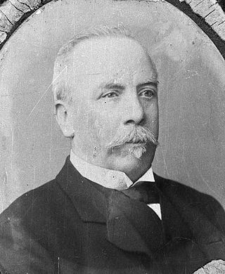
William James Mudie Larnach was a New Zealand businessman and politician. He is known for his extravagant incomplete house near Dunedin called Larnach's castle by his opponents and now known as Larnach Castle. He is also remembered for his suicide within parliament buildings when faced with bankruptcy and consequent loss of his seat in parliament.
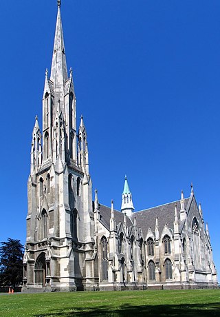
First Church is a prominent church in the New Zealand city of Dunedin. It is located in the heart of the city on Moray Place, 100 metres to the south of the city centre. The church is the city's primary Presbyterian church. The building is regarded as the most impressive of New Zealand's nineteenth-century churches, and is listed by Heritage New Zealand as a Category I structure.

Princes Street is a major street in Dunedin, the second largest city in the South Island of New Zealand. It runs south-southwest for two kilometres from The Octagon in the city centre to the Oval sports ground, close to the city's Southern Cemetery. North of The Octagon, George Street continues the line of Princes Street north-northeast for two and a half kilometres. Princes Street is straight but undulating, skirting the edge of the City Rise to its northwest. The part of the street immediately below The Octagon is the steepest section, as the road traverses an old cutting through Bell Hill.

Robert Arthur Lawson was one of New Zealand's pre-eminent 19th century architects. It has been said he did more than any other designer to shape the face of the Victorian era architecture of the city of Dunedin. He is the architect of over forty churches, including Dunedin's First Church for which he is best remembered, but also other buildings, such as Larnach Castle, a country house, with which he is also associated.
George O'Brien (1821–1888) was an engineer of aristocratic background who turned to art in 19th century Australasia, dying in poverty but leaving a body of remarkable work.

The Dunedin Botanic Garden is located at the northern end of central Dunedin, in the South Island of New Zealand. The garden is close to the University of Otago and one of the city's most historic cemeteries, the Northern Cemetery, on a spur of Signal Hill and on the river plain immediately below it.
Waverley is a suburb of the New Zealand city of Dunedin. It was named after Sir Walter Scott's novel Waverley, first novel in a series known as the Waverley Novels, among the most popular and widely read English-language novels of the 19th century. Waverley is located at the start of the Otago Peninsula, 2.4 kilometres (1.5 mi) southeast of the city centre, on a rise overlooking the Otago Harbour to the north.
Dunedin North, also known as North Dunedin, is a major inner suburb of the New Zealand city of Dunedin, located 1.5 kilometres (0.93 mi) northeast of the city centre. It contains many of the city's major institutions, including the city's university, polytechnic, main hospital, and largest museum. Dunedin North's 2001 population was 7,047, including the university area.

Caversham is one of the older suburbs of the city of Dunedin, in New Zealand's South Island. It is sited at the western edge of the city's central plain at the mouth of the steep Caversham Valley, which rises to the saddle of Lookout Point. Major road and rail routes south lie nearby; the South Island Main Trunk railway runs through the suburb, and a bypass skirts its main retail area, connecting Dunedin's one-way street system with the Dunedin Southern Motorway. The suburb is linked by several bus routes to its neighbouring suburbs and central Dunedin.
Ōpoho is a suburb of the New Zealand city of Dunedin. It sits on the western flank of Signal Hill, New Zealand, 3 kilometres (1.9 mi) to the northeast of the city centre, overlooking North East Valley and the Dunedin Botanic Gardens.
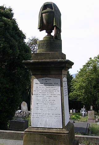
The Southern Cemetery in the New Zealand city of Dunedin was the first major cemetery to be opened in the city. The cemetery was opened in 1858, ten years after the founding of the city in an area known as Little Paisley. This area lies at the southern end of Princes Street, one of the city's main streets, close to the suburbs of Kensington, Maryhill, and The Glen.

The Town Belt is a green belt which surrounds the centre of the New Zealand city of Dunedin. Covering a total of over 200 hectares, it extends around three sides of the city's centre at a distance from it of some 1-3 km in a broad 7 km crescent from the Oval at Kensington in the south through the suburbs of Mornington, City Rise, Belleknowes, Roslyn, Maori Hill, Prospect Park, Glenleith, Woodhaugh, The Gardens and Dunedin North and the slopes of Signal Hill. The fourth side of the central city is bounded by the Otago Harbour.

Andersons Bay Cemetery is a major cemetery in the New Zealand city of Dunedin. It is located 4 kilometres (2.5 mi) to the southeast of the city centre, on a rocky outcrop which forms the inland part of Lawyers Head, a promontory which juts into the Pacific Ocean. The cemetery is bounded on the western and southern sides by Chisholm Park Golf Links, and to the east by steep slopes which descend to the Tomahawk Lagoon. Despite its name, the cemetery is located in the suburb of Tahuna, which lies immediately to the south of the suburb of Andersons Bay, and almost 1 kilometre (0.62 mi) from the former bay itself, at the head of the Otago Harbour.

All Saints has been open since 1865, and is presently in the Dunedin North parish which includes the northern part of the city of Dunedin, New Zealand and is made up of the former parish of All Saints and the former parish of St. Martin's North East Valley. It is part of the Diocese of Dunedin. The parish boundaries include North East Valley, Pine Hill, North Dunedin, Ravensbourne and Leith Valley. The building is the oldest church still used as a place of worship in Dunedin. All Saints Church is the chapel of Selwyn College, Otago. The College was built around the church and the college and parish have a close relationship. Selwyn College was built as an Anglican theological college in 1893, from the beginning it also housed non-theological students from the university. All Saints' is located close to the campuses of the University of Otago and the Otago Polytechnic.

The Warehouse Precinct is an urban area of the New Zealand city of Dunedin. Sited on reclaimed land at the northernmost tip of the Southern Endowment, it lies between 1 and 2 kilometres south of The Octagon, the city's centre.


