
Middlemarch is a small town in the Otago region of New Zealand's South Island. It lies at the foot of the Rock and Pillar Range of hills in the broad Strath-Taieri valley, through which flows the middle reaches of the Taieri River. Since local government reorganisation in the late 1980s, Middlemarch and much of the Strath-Taieri has been administered as part of Dunedin city, the centre of which lies some 80 km to the southeast. Middlemarch is part of the Taieri electorate, and is currently represented in parliament by Ingrid Leary. Middlemarch has reticulated sewerage but no reticulated water supply. A description of 1903, that "[T]he summer seasons are warm, but not enervating, and the winters cold, but dry" is still true today.
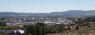
Mosgiel is an urban satellite of Dunedin in Otago, New Zealand, fifteen kilometres west of the city's centre. Since the re-organisation of New Zealand local government in 1989 it has been inside the Dunedin City Council area. Mosgiel has a population of approximately 14,800 as of June 2023. A nickname for Mosgiel is "The pearl of the plain". Its low-lying nature does pose problems, making it prone to flooding after heavy rains. Mosgiel takes its name from Mossgiel Farm, Ayrshire, the farm of the poet Robert Burns, the uncle of the co-founder in 1848 of the Otago settlement, the Reverend Thomas Burns.
The Taieri Plain is an area of fertile agricultural land to the southwest of Dunedin, in Otago, New Zealand. The plain covers an area of some 300 square kilometres, with a maximum extent of 30 kilometres. It is not to be confused with Strath Taieri, a second plain of the Taieri River, 40kms to the north beyond Mount Ross.
Brighton is a small seaside town within the city limits of Dunedin on New Zealand's South Island. It is located 20 kilometres southwest from the city centre on the Southern Scenic Route.

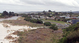
Taieri Mouth is a small fishing village at the mouth of the Taieri River, New Zealand. Taieri Island (Moturata) lies in the ocean several hundred metres off the river's mouth.

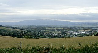
The Strath Taieri is a large glacial valley and river plateau in New Zealand's South Island. It is surrounded by the rugged hill ranges to the north and west of Otago Harbour. Since 1989 it has been part of the city of Dunedin. The small town of Middlemarch is located at its southern end.

Clutha District is a local government district of southern New Zealand, with its headquarters in the Otago town of Balclutha. Clutha District has a land area of 6,334.47 km2 (2,445.75 sq mi) and an estimated population of 18,900 as of June 2023. Clutha District occupies the majority of the geographical area known as South Otago.

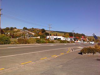
Outram is a rural suburb of Dunedin, New Zealand, with a population of 880 as of June 2023. It is located 28 kilometres west of the central city at the edge of the Taieri Plains, close to the foot of Maungatua. The Taieri River flows close to the southeast of the town. Outram lies on State Highway 87 between Mosgiel and Middlemarch.
Allanton is a small town in Otago, New Zealand, located some 20 kilometres southwest of Dunedin on State Highway 1. The settlement lies at the eastern edge of the Taieri Plains close to the Taieri River at the junction of the main road to Dunedin International Airport at Momona.

Saddle Hill is a prominent landmark overlooking the northeastern end of the Taieri Plains in Otago, New Zealand. Within the limits of Dunedin city, it is located 18 kilometres to the west of the city centre, between Mosgiel and Green Island, and is clearly visible from many of the city's southern hill suburbs. A lookout on the northern slopes of the hill commands a good view across the plains, with Lake Waihola visible 25 kilometres to the west in clear weather.
The township of Waihola lies between Dunedin and Milton, New Zealand in Otago, in New Zealand's South Island. It lies close to the southeast shore of the shallow tidal lake which shares its name.
Wakari is a residential suburb of the New Zealand city of Dunedin. It is located 2.5 kilometres (1.6 mi) to the northwest of the city centre, immediately to the west of the ridge which runs to the west of the city's centre. Wakari lies to the north of the upper reaches of the Kaikorai Valley, and is also north of the suburb of Kaikorai. The suburbs of Roslyn and Maori Hill are situated on the ridge immediately to the southeast and east of Wakari. The suburb of Halfway Bush lies to the northwest, and the smaller suburb of Helensburgh lies to the north.
Waldronville is a coastal settlement on the Pacific Ocean coast of the South Island of New Zealand. Established in the 1950s as a commuter settlement, it is located 13 kilometres (8.1 mi) to the southwest of Dunedin city centre, and lies within the city's limits. Waldronville was developed by Bill Waldron, when he purchased the McCraws farm in the early 1950s, initially for 200 houses. In the mid-1970s, two other streets were added to the southwest of the settlement. In the mid-1990s, Friendship Drive and Wavy Knowes developments were added to the northeast.

Halfway Bush is a suburb of the New Zealand city of Dunedin. It is located 3 kilometres (1.9 mi) to the northwest of the city centre, close to the point at which Taieri Road becomes the winding rural Three Mile Hill Road. It was this road which gave the suburb its name, as this locality was halfway between the Taieri Plains and central Dunedin in the early days of European settlement, when Three Mile Hill was the main route from Dunedin to the Otago hinterland. This route was superseded by the route through the Caversham Valley in the 1860s.
Helensburgh is a suburb of the New Zealand city of Dunedin. It is located to the northwest of the city centre.

Wingatui is a small settlement almost 15 kilometres west of Dunedin, and two kilometres east of Mosgiel. It has become a suburb of Mosgiel, but continues to maintain its own unique identity and heritage.
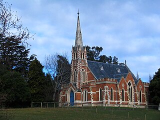
East Taieri is a small township, located between Mosgiel and Allanton in New Zealand's Otago region. It lies on State Highway 1 en route between the city of Dunedin and its airport at Momona. It lies close to the southeastern edge of the Taieri Plain, hence its name.

Nayland is a suburb of Stoke, New Zealand. It lies to the north of Stoke, close to Nelson Airport, southwest of Nelson city centre.
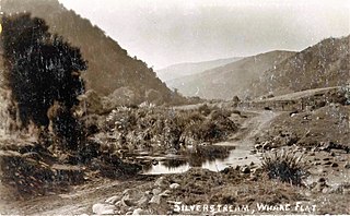
Whare Flat is a locality some 15 km to the northwest of Dunedin city centre, in the South Island of New Zealand. It is located at a widening of the Silver Stream's valley amid the foothills of the Silverpeaks.
Harwood is a rural settlement on the northern side of the Otago Peninsula. It is within the boundaries of Dunedin city in New Zealand.
