
The Cook Islands is a self-governing island country in the South Pacific Ocean in free association with New Zealand. It comprises 15 islands whose total land area is 240 square kilometres (93 sq mi). The Cook Islands' Exclusive Economic Zone (EEZ) covers 1,960,027 square kilometres (756,771 sq mi) of ocean.
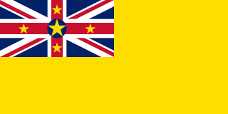
Niue is a self-governing territory of New Zealand in the South Pacific Ocean, 2,400 kilometres (1,500 mi) northeast of New Zealand. Niue's land area is about 261 square kilometres (101 sq mi) and its population, predominantly Polynesian, was about 1,600 in 2016. Niue is located in a triangle between Tonga, Samoa, and the Cook Islands. It is 604 kilometres northeast of Tonga. The island is commonly referred to as "The Rock", which comes from the traditional name "Rock of Polynesia". Niue is one of the world's largest coral islands. The terrain of the island has two noticeable levels. The higher level is made up of a limestone cliff running along the coast, with a plateau in the centre of the island reaching approximately 60 metres above sea level. The lower level is a coastal terrace approximately 0.5 km wide and about 25–27 metres high, which slopes down and meets the sea in small cliffs. A coral reef surrounds the island, with the only major break in the reef being in the central western coast, close to the capital, Alofi.

Oceania is a geographical region that is described as a continent in some parts of the world. It includes Australasia, Melanesia, Micronesia, and Polynesia. Spanning the Eastern and Western hemispheres, at the center of the water hemisphere, Oceania is estimated to have a land area of 8,525,989 square kilometres (3,291,903 sq mi) and a population of around 44.4 million as of 2022. Oceania is described as a geographical region in most of the English-speaking world, but outside of the English-speaking world, Oceania is described as one of the continents. In this model of the world, Australia is either seen as an island or a continental landmass contained inside of the larger continent of Oceania. When compared to the other continents, Oceania is the smallest in land area and the second-least populated after Antarctica.

Tokelau is a dependent territory of New Zealand in the southern Pacific Ocean. It consists of three tropical coral atolls: Atafu, Nukunonu, and Fakaofo. They have a combined land area of 10 km2 (4 sq mi). The capital rotates yearly among the three atolls. In addition to these three, Swains Island, which forms part of the same archipelago, is the subject of an ongoing territorial dispute; it is currently administered by the United States as part of American Samoa. Tokelau lies north of the Samoan Islands, east of Tuvalu, south of the Phoenix Islands, southwest of the more distant Line Islands, and northwest of the Cook Islands.
D'Urville Island, Māori name Rangitoto ki te Tonga, is an island in the Marlborough Sounds along the northern coast of the South Island of New Zealand. It was named after the French explorer Jules Dumont d'Urville. With an area of approximately 150 square kilometres (58 sq mi), it is the eighth-largest island of New Zealand, and has around 52 permanent residents. The local authority is the Marlborough District Council.

The South Island, also officially named Te Waipounamu, is the larger of the two major islands of New Zealand in surface area, the other being the smaller but more populous North Island. It is bordered to the north by Cook Strait, to the west by the Tasman Sea, and to the south and east by the Pacific Ocean. The South Island covers 150,437 square kilometres (58,084 sq mi), making it the world's 12th-largest island. At low altitude, it has an oceanic climate.

The Tasman Sea is a marginal sea of the South Pacific Ocean, situated between Australia and New Zealand. It measures about 2,000 km (1,200 mi) across and about 2,800 km (1,700 mi) from north to south. The sea was named after the Dutch explorer Abel Janszoon Tasman, who in 1642 was the first known person to cross it. British explorer Lieutenant James Cook later extensively navigated the Tasman Sea in the 1770s during his three voyages of exploration.

Hawke's Bay is a local government region on the east coast of New Zealand's North Island. The region's name derives from Hawke Bay, which was named by Captain James Cook in honour of Admiral Edward Hawke. The region is governed by Hawke's Bay Regional Council.
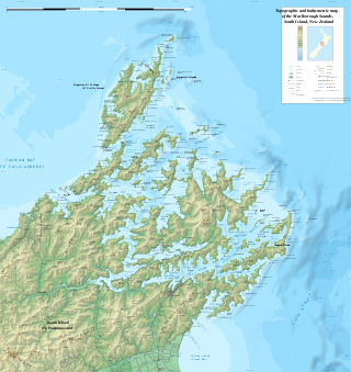
The Marlborough Sounds are an extensive network of sea-drowned valleys at the northern end of the South Island of New Zealand. The Marlborough Sounds were created by a combination of land subsidence and rising sea levels. According to Māori mythology, the sounds are the prows of the many sunken waka of Aoraki.

Pacific Islanders, Pasifika, Pasefika, Pacificans or rarely Pacificers are the peoples of the Pacific Islands. As an ethnic/racial term, it is used to describe the original peoples—inhabitants and diasporas—of any of the three major subregions of Oceania.

The Northland Region is the northernmost of New Zealand's 16 local government regions. New Zealanders sometimes refer to it as the Winterless North because of its mild climate all throughout the year. The main population centre is the city of Whangārei, and the largest town is Kerikeri. At the 2018 New Zealand census, Northland recorded a population growth spurt of 18.1% since the previous 2013 census, placing it as the fastest growing region in New Zealand, ahead of other strong growth regions such as the Bay of Plenty Region and Waikato.
Polynesians form an ethnolinguistic group of closely related people who are native to Polynesia, an expansive region of Oceania in the Pacific Ocean. They trace their early prehistoric origins to Island Southeast Asia and form part of the larger Austronesian ethnolinguistic group with an Urheimat in Taiwan. They speak the Polynesian languages, a branch of the Oceanic subfamily of the Austronesian language family. The Indigenous Māori people constitute the largest Polynesian population, followed by Samoans, Native Hawaiians, Tahitians, Tongans and Cook Islands Māori
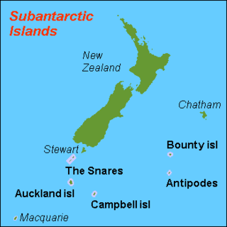
The New Zealand Subantarctic Islands comprise the five southernmost groups of the New Zealand outlying islands. They are collectively designated as a UNESCO World Heritage Site.

The Realm of New Zealand is the area over which the monarch of New Zealand is head of state. The realm is not a federation but is a collection of states and territories united under its monarch. New Zealand is an independent and sovereign state that has one territory in Antarctica, one dependent territory (Tokelau), and two associated states. The Realm of New Zealand encompasses the three autonomous jurisdictions of New Zealand, the Cook Islands, and Niue.

The 180th meridian or antimeridian is the meridian 180° both east and west of the prime meridian in a geographical coordinate system. The longitude at this line can be given as either east or west.

New Zealand is an island country in the southwestern Pacific Ocean. It consists of two main landmasses—the North Island and the South Island —and over 700 smaller islands. It is the sixth-largest island country by area and lies east of Australia across the Tasman Sea and south of the islands of New Caledonia, Fiji, and Tonga. The country's varied topography and sharp mountain peaks, including the Southern Alps, owe much to tectonic uplift and volcanic eruptions. New Zealand's capital city is Wellington, and its most populous city is Auckland.

The Antarctic Floristic Kingdom, also the Holantarctic Kingdom, is a floristic kingdom that includes most areas of the world south of 40°S latitude. It was first identified by botanist Ronald Good, and later by Armen Takhtajan. The Antarctic Floristic Kingdom is a classification in phytogeography, different from the Antarctic realm classification in biogeography, and from Antarctic flora genera/species classifications in botany.

Stewart Island is New Zealand's third-largest island, located 30 kilometres south of the South Island, across the Foveaux Strait. It is a roughly triangular island with a total land area of 1,746 km2 (674 sq mi). Its 164-kilometre (102 mi) coastline is deeply creased by Paterson Inlet (east), Port Pegasus (south), and Mason Bay (west). The island is generally hilly and densely forested. Flightless birds, including penguins, thrive because there are few introduced predators. Almost all the island is owned by the New Zealand government, and over 80 per cent of the island is set aside as the Rakiura National Park.

The COVID-19 pandemic in the Cook Islands is part of the ongoing worldwide pandemic of coronavirus disease 2019 caused by severe acute respiratory syndrome coronavirus 2. As of 30 October 2021, 12,841 first doses and 12,498 second doses of vaccine had been administered, which represents over 97% of the eligible population (12+) fully vaccinated.
The COVID-19 pandemic in Tokelau is part of the ongoing worldwide pandemic of coronavirus disease 2019 caused by severe acute respiratory syndrome coronavirus 2. Tokelau reported its first confirmed case on 21 December 2022. COVID-19 reached all three of Tokelau's main atolls in July 2023, when the government confirmed the community spread of the virus on Fakaofo, the last atoll without infections.
