Related Research Articles
Speight's is a beer brand and a brewery located in Dunedin, New Zealand. The brand is owned by the Japanese-controlled holding company Lion, itself a subsidiary of Kirin. Speight's is best known for its Gold Medal Ale, one of the best-selling beers in New Zealand. The brewery also includes a chain of "Speight's Ale House" gastropubs across the country.

Queenstown is a resort town in Otago in the south-west of New Zealand's South Island. It is the seat and largest town in the Queenstown-Lakes District.

Alexandra is a town in the Central Otago district of the South Island of New Zealand. It is on the banks of the Clutha River, on State Highway 8, 188 kilometres (117 mi) by road from Dunedin and 33 kilometres (21 mi) south of Cromwell. The nearest towns to Alexandra via state highway 8 are Clyde seven kilometres to the northwest and Roxburgh forty kilometres to the south. State highway 85 also connects Alexandra to Omakau, Lauder, Oturehua, Ranfurly and on to Palmerston on the East Otago coast.

Bluff, previously known as Campbelltown and often referred to as "The Bluff", is a town and seaport in the Southland region, on the southern coast of the South Island of New Zealand. It is the southernmost town in mainland New Zealand and, despite Slope Point and Stewart Island being further south, Bluff is colloquially used to refer to the southern extremity of the country. According to the 2018 census, the resident population was 1,797, a decrease of 6 since 2013.

Haast is a small town in the Westland District on the West Coast of New Zealand's South Island. The township is beside the Haast River, 3 kilometres (2 mi) south of Haast Junction, on State Highway 6. The Haast region is in Te Wahipounamu – The South West New Zealand World Heritage, a UNESCO World Heritage Site designated in 1990.

Cromwell is a town in Central Otago region of the South Island of New Zealand. Cromwell is located on the shores of Lake Dunstan where the Kawarau river joins Lake Dunstan. Cromwell was established during the Otago gold rush and is now more known as one of the sub regions of the Central Otago wine region. In 2018, the town of Cromwell was home to a population of 5610 people.

Wānaka is a popular ski and summer resort town in the Otago region of the South Island of New Zealand. At the southern end of Lake Wānaka, it is at the start of the Clutha River and is the gateway to Mount Aspiring National Park.

Milton, formerly known as Tokomairiro or Tokomairaro, is a town of over 2,000 people, located on State Highway 1, 50 kilometres to the south of Dunedin in Otago, New Zealand. It lies on the floodplain of the Tokomairaro River, one branch of which loops past the north and south ends of the town. This river gives its name to many local features, notably the town's only secondary school, Tokomairiro High School.

The Maniototo Plain, usually simply known as The Maniototo, is an elevated inland region in Otago, New Zealand. The region roughly surrounds the upper reaches of the Taieri River and the Manuherikia River. It is bounded by the Kakanui Range to the north and the Rock and Pillar Range to the southeast. It has a harsh, dry climate, ranging from over 30 °C in mid-summer to -15 °C in mid-winter.
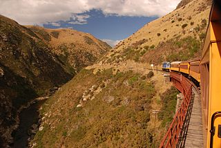
Dunedin Railways is the trading name of Dunedin Railways Limited, an operator of a railway line and tourist trains based at Dunedin Railway Station in the South Island of New Zealand. The company is a council-controlled trading organisation wholly owned by Dunedin City Council through its holding company Dunedin City Holdings Limited.
Berwick is a small farming community on the banks of the Waipori River at the southwestern limit of Dunedin city, New Zealand, some 40 kilometres from the city centre. It lies close to the border with Clutha District. To the south of Berwick is the Berwick Forest, a large pine plantation.

George Street is the main street of Dunedin, the second largest city in the South Island of New Zealand. It runs for two and a half kilometres north-northeast from The Octagon in the city centre to the foot of Pine Hill. It is straight and undulates gently as it skirts the edge of the hills to its northwest. South of The Octagon, Princes Street continues the line of George Street south-southwest for two kilometres.
Paerau is a small settlement in inland Central Otago in New Zealand's South Island. It is located in the Strath Taieri, the upper valley of the Taieri River, at the foot of the Rock and Pillar Range. "Paerau" is a Māori-language name meaning "one hundred ridges".

Princes Street is a major street in Dunedin, the second largest city in the South Island of New Zealand. It runs south-southwest for two kilometres from The Octagon in the city centre to the Oval sports ground, close to the city's Southern Cemetery. North of The Octagon, George Street continues the line of Princes Street north-northeast for two and a half kilometres. Princes Street is straight but undulating, skirting the edge of the City Rise to its northwest. The part of the street immediately below The Octagon is the steepest section, as the road traverses an old cutting through Bell Hill.

Hillside Engineering Group is a trading division of the rail operator KiwiRail in Dunedin, New Zealand. Most of its work is related to KiwiRail, but it also does work for the marine industry in Dunedin. On 19 April 2012 KiwiRail announced it was putting Hillside on the market for sale. In November 2012 KiwiRail announced it had sold part of the business to Australian firm Bradken, and the rest would be closed. The workshops continued to be used for some maintenance work by Kiwirail with a skeleton staff. In October 2019, the New Zealand Government announced that it would be investing NZ$20 million into revitalising Hillside Engineering as a major mechanical hub and engineering facility to service Kiwi Rail's locomotives and rollingstock.

Otago Polytechnic is a public New Zealand tertiary education institute, centred in Dunedin with additional campuses in Cromwell and Auckland. Otago Polytechnic provides career-focused education and training, offering a range of New Zealand accredited postgraduate qualifications, degrees, diplomas and certificates at levels 2–10. In November 2022, it became a business unit of the national mega polytechnic Te Pūkenga, ending its existence as an independent entity.
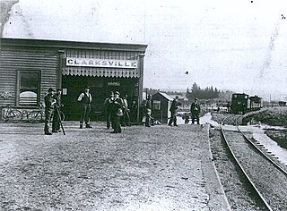
Clarksville is a small township located three kilometres southwest of Milton in the Otago region of the South Island of New Zealand. State Highways 1 and 8 meet in Clarksville. The town was also once the location of a railway junction, where the Roxburgh Branch left the Main South Line. Construction of this branch line began in the 1870s, and Clarksville acted as the junction until 1907 when an extension of the branch was built alongside the Main South Line into Milton to improve operations. This led to Milton being the junction until 1960, when the extension was removed, and Clarksville regained its status as a junction until the branch was entirely closed in 1968.
Queenstown Police Station is the largest police station in the Otago Lakes Central Area which is one of three policing areas in the Southern District of the New Zealand Police. The Otago Lakes Central Area headquarters has returned to Queenstown Police Station after a period at Alexandra Police Station. The area of responsibility covered by the Queenstown Police extends from Kingston in the south, to the Crown Range summit in the north, and from Glenorchy and its environs in the west, to the Roaring Meg power station in the Kawarau Gorge in the east.
Parawa is a locality in Southland, New Zealand, on State Highway 6, 5 km southwest of Athol and immediately north of Mid Dome mountain. Its name is a corruption of Paiherewao, what Maori called the mountain. In the 19th century, several versions of the name were used, including Parrawa and Parrowa.
Kyeburn is a small settlement in Otago, in the South Island of New Zealand. It lies on the Maniototo, a wide, high plain stretching from the end of the Strath-Taieri valley.
References
- ↑ "Clarks Junction," NZ Topo Map. Retrieved 12 March 2022.
- ↑ Reed, A.W. (1975). Place names of New Zealand. Wellington: A.H. & A.W. Reed. p.80.
- ↑ "Colourful history of Central Otago's Clarks Junction Hotel revealed," "The Country", nzherald.co.nz, 29 August 2018. Retrieved 12 March 2022.
- ↑ McAvinue, Shawn (8 March 2021). "Sale of well-loved pub disappoints locals". Otago Daily Times Online News. Retrieved 20 July 2022.
- ↑ Lewis, John (21 September 2021). "Former pub now a family home". Otago Daily Times Online News. Retrieved 20 July 2022.
45°43′35″S170°02′50″E / 45.72639°S 170.04722°E
| | This Otago geography article is a stub. You can help Wikipedia by expanding it. |