Related Research Articles
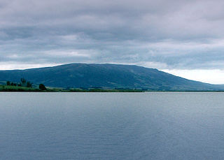
Maungatua, known also as Maukaatua is a prominent ridge in the Taieri Plains in Otago, New Zealand.
Dunedin Railways is the trading name of Dunedin Railways Limited, an operator of a railway line and tourist trains based at Dunedin Railway Station in the South Island of New Zealand. The company is a council-controlled trading organisation wholly owned by Dunedin City Council through its holding company Dunedin City Holdings Limited.

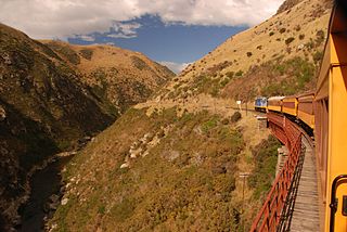
The Silverpeaks is an area of rough forest and tussock and scrub covered hill country inland and to the northwest of Dunedin, New Zealand. The area is largely uninhabited; the main indication of human activity is the Taieri Gorge Railway, which preserves the route of the former Otago Central Railway that runs along the steep-sided valley of the Taieri River. Much of the area lies within the Silverpeaks Scenic Reserve.
Berwick is a small farming community on the banks of the Waipori River at the southwestern limit of Dunedin city, New Zealand, some 40 kilometres from the city centre. It lies close to the border with Clutha District. To the south of Berwick is the Berwick Forest, a large pine plantation.

Dunedin railway station is a prominent landmark and tourist site in Dunedin, a city in the South Island of New Zealand. It is speculated by locals to be the most photographed building in the country, as well as the second most photographed in the southern hemisphere, after the Sydney Opera House.

Arana College is a residential college of the University of Otago in Dunedin, New Zealand, founded in 1943 by the Rev. Harold W.Turner and the Stuart Residence Halls Council. The name "Arana" is a Māori transliteration of "Allen", chosen to honour Sir James Allen, a former Vice Chancellor (1903–1909) and Chancellor (1909–1912) of the University of Otago. The current warden is Ruben Katigbak.

The Octagon is the city centre of Dunedin, in the South Island of New Zealand. It is an eight-sided plaza with a circular one-way carriageway, bisected by the city's main street, and is also the central terminus of two other main thoroughfares. The Octagon is predominantly a pedestrian reserve, with grass and paved features, and is surmounted by a statue of the Scottish poet Robert Burns. Several of Dunedin's significant buildings and institutions adjoin the plaza, which is also a major hub for public transport in Dunedin, primarily taxi services.

Otago Polytechnic was a public New Zealand tertiary education institute, centred in Dunedin with additional campuses in Cromwell and Auckland. Otago Polytechnic provided career-focused education and training, offering a range of New Zealand accredited postgraduate qualifications, degrees, diplomas and certificates at levels 2–10. In November 2022, it was formally merged into the new national mega polytechnic Te Pūkenga, ending its existence as an independent entity.
Otago Regional Council (ORC) is the regional council for Otago in the South Island of New Zealand. The council's principal office is Regional House on Stafford Street in Dunedin with 250–275 staff, with smaller offices in Queenstown and Alexandra. They are responsible for sustainably managing Otago’s natural resources of land, air and water on behalf of the community. Property owners pay rates to both the local and regional councils.

The Toitū Otago Settlers Museum is a regional history museum in Dunedin, New Zealand. Its brief covers the territory of the old Otago Province, that is, New Zealand from the Waitaki River south, though its main focus is the city of Dunedin. It is New Zealand's oldest history museum.
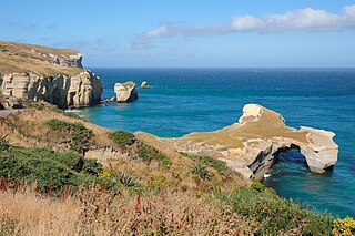
Tunnel Beach is a locality 7.5 kilometres (4.7 mi) southwest of the city centre of Dunedin, New Zealand. Located just south of St Clair, Tunnel Beach has sea-carved sandstone cliffs, rock arches and caves. Beyond the beauty of the rugged sandstone cliffs, its claim to fame is the tunnel down to the beach that a local politician, John Cargill, son of Captain William Cargill, had commissioned for his family in the 1870s. Local legend says that one or more of Cargill's daughters drowned while swimming at the beach, but there is no truth to this story.
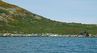
The settlement of Harington Point lies within the boundaries of the city of Dunedin, New Zealand. It is located at the Otago Heads, at the northeastern end of Otago Peninsula, close to the entrance of Otago Harbour. The mouth of the harbour is at its narrowest at Harington Point, only some 400 metres separating the point from the mudflats at Aramoana on the opposing coast.

Orokonui Ecosanctuary, called Te Korowai o Mihiwaka in Māori, is an ecological island wildlife reserve developed by the Otago Natural History Trust in the Orokonui Valley between Waitati and Pūrākaunui, New Zealand, 20 kilometres (12 mi) to the north of central Dunedin.

The Town Belt is a green belt which surrounds the centre of the New Zealand city of Dunedin. Covering a total of over 200 hectares, it extends around three sides of the city's centre at a distance from it of some 1-3 km in a broad 7 km crescent from the Oval at Kensington in the south through the suburbs of Mornington, City Rise, Belleknowes, Roslyn, Maori Hill, Prospect Park, Glenleith, Woodhaugh, The Gardens and Dunedin North and the slopes of Signal Hill. The fourth side of the central city is bounded by the Otago Harbour.

Dunedin–Waitati Highway, formerly called Dunedin Northern Motorway, is a two-to-four-lane limited-access road which provides the main route north from the city of Dunedin, New Zealand. Opened on 14 December 1957, it superseded the narrow and winding routes via Port Chalmers and Mount Cargill. The road is occasionally briefly closed by snowfall in winter.

The Warehouse Precinct is an urban area of the New Zealand city of Dunedin. Sited on reclaimed land at the northernmost tip of the Southern Endowment, it lies between 1 and 2 kilometres south of The Octagon, the city's centre.

Aaron Garth Hawkins is a New Zealand politician who served as the 58th mayor of Dunedin, New Zealand from 2019 to 2022. He was elected as Mayor on 12 October 2019 with 54.54% of the vote, after two prior terms as councillor. He is endorsed by the Green Party. He unsuccessfully stood for re-election as mayor in 2022.

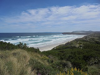
Smaills Beach is a beach on the Pacific Ocean 7.6 kilometres (4.7 mi) southeast of the city centre of Dunedin, New Zealand. Located within the Ocean Grove Reserve adjacent to Tomahawk Beach, at the point where Otago Peninsula joins the mainland of the South Island, Smaills Beach is a white sand beach for much of its length, but its western end is covered in volcanic boulders. Just offshore from the beach, dominating the wave patterns of the surf, is the rocky outcrop known as Bird Island. Smaills Beach is clothing-optional, renowned for its wildlife, and popular with surfers.
Tomahawk Beach is a beach on the Pacific Ocean 7.5 kilometres (4.7 mi) southeast of the city centre of Dunedin, New Zealand. Located within the Ocean Grove Reserve between St Kilda Beach and Smaills Beach, at the point where Otago Peninsula joins the mainland of the South Island, Tomahawk Beach is a white sand beach popular with casual beach-goers and dog-walkers as well as surfers. Sand is extracted from the Tomahawk Lagoon channel, which runs across the beach, for commercial purposes and to prevent flooding.

Dunedin Athenaeum and Mechanics' Institute is an adult education institute based in a heritage building in Dunedin, New Zealand. The private organisation provided classes and a library for members. Presently it operates a subscription lending library, and includes a basement theatre that has been operated by the Dunedin Collaborative Theatre Trust since 2016. The Athenaeum building is one of the oldest athenaeums in New Zealand still used for its original purpose, and is classified as a "Category I" historic place by Heritage New Zealand Pouhere Taonga, previously known as the New Zealand Historic Places Trust.
References
- 1 2 3 4 Stevens, Sam (29 May 2008). "Planting seedlings for the future". Otago Daily Times Online News. Retrieved 4 June 2020.
- 1 2 Star, Star (18 January 2015). "'Bandits' have big plans for park". Otago Daily Times Online News. Retrieved 4 June 2020.
- ↑ "North East Valley Walks | Bitfern" . Retrieved 4 June 2020.
- ↑ "Garden to feed Dalmore's folk". Otago Daily Times Online News. 20 October 2016. Retrieved 4 June 2020.
- ↑ Elder, Vaughan (27 December 2015). "Pine Hill digging its own garden". Otago Daily Times Online News. Retrieved 4 June 2020.
- ↑ "August 2017". Eco Living in Action. Retrieved 4 June 2020.
45°50′59″S170°31′05″E / 45.84972°S 170.51806°E
| | This Otago geography article is a stub. You can help Wikipedia by expanding it. |