St Leonards, Dunedin

Last updated
Dunedin, New Zealand location map.PNG
Red pog.svg
St Leonards

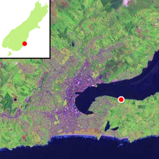
St Leonards is a suburb of the New Zealand city of Dunedin. It is located close to the northern shore of the Otago Harbour and on the hilly slopes above the harbour. St Leonards is 8.5 kilometres (5.3 mi) northeast of Dunedin's city centre, between the small settlement of Burkes and Sawyers Bay. [1] St Leonards was named by early settler David Carey for the birthplace of his wife, the English town of St Leonards-on-Sea, on the Sussex coast. [2] [3]

New Zealand Constitutional monarchy in Oceania

New Zealand is a sovereign island country in the southwestern Pacific Ocean. The country geographically comprises two main landmasses—the North Island, and the South Island —and around 600 smaller islands. New Zealand is situated some 2,000 kilometres (1,200 mi) east of Australia across the Tasman Sea and roughly 1,000 kilometres (600 mi) south of the Pacific island areas of New Caledonia, Fiji, and Tonga. Because of its remoteness, it was one of the last lands to be settled by humans. During its long period of isolation, New Zealand developed a distinct biodiversity of animal, fungal, and plant life. The country's varied topography and its sharp mountain peaks, such as the Southern Alps, owe much to the tectonic uplift of land and volcanic eruptions. New Zealand's capital city is Wellington, while its most populous city is Auckland.

Dunedin City in Otago, New Zealand

Dunedin is the second-largest city in the South Island of New Zealand, and the principal city of the Otago region. Its name comes from Dùn Èideann, the Scottish Gaelic name for Edinburgh, the capital of Scotland.

Otago Harbour The natural harbour of Dunedin, New Zealand

Otago Harbour is the natural harbour of Dunedin, New Zealand, consisting of a long, much-indented stretch of generally navigable water separating the Otago Peninsula from the mainland. They join at its southwest end, 21 km (13 mi) from the harbour mouth. It is home to Dunedin's two port facilities, Port Chalmers and at Dunedin's wharf. The harbour has been of significant economic importance for approximately 700 years, as a sheltered harbor and fishery, then deep water port.

Rail and road links between central Dunedin and Port Chalmers run alongside St Leonards on the narrow strip of land between the hill slopes and harbour. The suburb is separate from the contiguous urban area of Dunedin.

Port Chalmers human settlement in New Zealand

Port Chalmers is a suburb and the main port of the city of Dunedin, New Zealand, with a population of 3,000. Port Chalmers lies ten kilometres inside Otago Harbour, some 15 kilometres northeast from Dunedin's city centre.

The suburb is residential, and contains a significant number of smaller homes. The area is a popular residence for students from the University of Otago, and is also popular with alternative lifestylers. The suburb consists mainly of two roughly parallel roads, the Dunedin-Port Chalmers highway (State Highway 88), which runs close to the harbour, and St Leonards Drive, the former main route to Port Chalmers, which winds around the lower slopes of the hills on which St Leonards sits. The Port Chalmers Branch railway line runs parallel with the highway next to the harbour's edge. In 2012, the Dunedin Harbour Cycleway was extended to reach St Leonards. [4]

University of Otago university in New Zealand

The University of Otago is a collegiate university located in Dunedin, Otago, New Zealand. It scores highly for average research quality, and in 2006 was second in New Zealand only to the University of Auckland in the number of A-rated academic researchers it employs. In the past it has topped the New Zealand Performance Based Research Fund evaluation.

State Highway 88 is a New Zealand State Highway connecting the city centre of Dunedin with Port Chalmers, which is the location of Dunedin's main port facilities and home of one of New Zealand's major container terminals. It is roughly 12 km long.

Port Chalmers Branch

The Port Chalmers Branch was the first railway line built in Otago, New Zealand, and linked the region's major city of Dunedin with the port in Port Chalmers. The line is still operational today.

The suburbs of St Leonards, Maia, Burkes, and Ravensbourne, are often collectively referred to as West Harbour. Under this name, the area was a separate borough for many years from 1877 until amalgamation with the city of Dunedin in 1963. [5]

Ravensbourne, New Zealand

Ravensbourne is a suburb of the New Zealand city of Dunedin. It is located on the steep southeastern slopes of Signal Hill above the Otago Harbour. It lies on the harbour's northern shore, 4.5 kilometres (2.8 mi) east-northeast of the city centre. Ravensbourne's 2001 population was 1,269.

Related Research Articles

Dunedin is a city of 130,700 people in the South Island of New Zealand. The principal suburbs of Dunedin are as follows. Inner and outer suburbs are ordered by location, clockwise from the city centre, starting due north:

Aramoana human settlement

Aramoana is a small coastal settlement, 27 kilometres north of Dunedin city, in the South Island of New Zealand. The settlement's permanent population in 2001 Census was 261. Supplementing this are seasonal visitors from the city who occupy cribs. The name Aramoana is Maori for "pathway of the sea".

Macandrew Bay human settlement in New Zealand

Macandrew Bay is located on the Otago Peninsula in the South Island of New Zealand. It is situated on the edge of Otago Harbour, and is named for pioneer settler James Macandrew who lived here during his later life. Early residents of the area called the bay "The Hundreds", due to the large number of boulders which covered the foreshore.

Logan Park, Dunedin

Logan Park is a sporting venue in the city of Dunedin, New Zealand. It lies on land reclaimed from the former Lake Logan.

Signal Hill (New Zealand)

Signal Hill is a prominent landform in the city of Dunedin, New Zealand. It is located close to, and due north of, the head of the Otago Harbour and reaches an elevation of 393 m (1289 ft). The suburbs Ravensbourne, St. Leonards, and Opoho lie on its southern, eastern, and northwestern flanks, respectively. To the northwest is North East Valley, the thalweg of Lindsay Creek, a tributary of the Water of Leith. The southernmost spur of Signal Hill, Logan Point, has been extensively quarried for road gravel. State Highway 88 skirts the foot of the hill close to the edge of the Otago Harbour.

St Kilda, New Zealand suburb of Dunedin, New Zealand

St Kilda is a suburb of the New Zealand city of Dunedin. A densely populated residential suburb, it lies on the southern part of the city's central plain, to the southwest of the head of the harbour and immediately north of Ocean Beach, parts of which are within the suburb and form its major geographical feature. Saint Kilda's 2001 population was 5,904.

Dunedin North Dunedin suburb

Dunedin North, also known as North Dunedin, is a major inner suburb of the New Zealand city of Dunedin, located 1.5 kilometres (0.93 mi) northeast of the city centre. It contains many of the city's major institutions, including the city's university, polytechnic, main hospital, and largest museum. Dunedin North's 2001 population was 7,047, including the university area.

Caversham, New Zealand suburb of the city of Dunedin, in New Zealands South Island

Caversham is one of the older suburbs of the city of Dunedin, in New Zealand's South Island. It is sited at the western edge of the city's central plain at the mouth of the steep Caversham Valley, which rises to the saddle of Lookout Point. Major road and rail routes south lie nearby; the South Island Main Trunk railway runs through the suburb, and a bypass skirts its main retail area, connecting Dunedin's one-way street system with the Dunedin Southern Motorway. The suburb is linked by several bus routes to its neighbouring suburbs and central Dunedin.

Ocean Grove, New Zealand human settlement in New Zealand

Ocean Grove, also known as Tomahawk, is a suburb in the southeast of the New Zealand city of Dunedin. A semi-rural residential suburb on the Pacific coast at the southwestern end of the Otago Peninsula, Ocean Grove is located 6.5 kilometres (4.0 mi) southeast of Dunedin city centre.

Sawyers Bay human settlement in New Zealand

Sawyers Bay is a suburb of the New Zealand city of Dunedin. It is located 3 kilometres (1.9 mi) to the southwest of Port Chalmers in a wide valley on the shore of Mussel Bay, 13 kilometres (8.1 mi) to the northeast of Dunedin city centre.

South Dunedin

South Dunedin is a major inner city suburb of the New Zealand city of Dunedin. It is located, as its name suggests, 2.5 kilometres (1.6 mi) to the south of the city centre, on part of a large plain known locally simply as "The Flat". The suburb is a mix of industrial, retail, and predominantly lower-quality residential properties. South Dunedin's 2006 population was 2,490, a decrease of 48 people from 2001.

Roseneath is a small suburb of the New Zealand city of Dunedin, located on the northwestern shore of Otago Harbour, 12 kilometres (7.5 mi) to the northeast of Dunedin city centre. It is situated between Saint Leonards and Port Chalmers on a rocky promontory of the same name which juts 0.6 kilometres (0.37 mi) into the harbour between Sawyers Bay and Blanket Bay. The suburb and promontory are likely to have been named from the similar location of Rosneath in Scotland.

Kensington, New Zealand suburb in Otago Region, New Zealand

Kensington is a small suburb of the New Zealand city of Dunedin, nestled to the south of a hilly spur between the central city and the major suburb of South Dunedin, some 2.4 kilometres (1.5 mi) to the south of the city centre. The suburb was named for the leafy London suburb, possibly by John Hyde Harris, who subdivided the area in the 1860s.

Challis, New Zealand

Challis is a settlement on the Otago Harbour coast of Otago Peninsula, within the city limits of the New Zealand city of Dunedin. Though officially regarded as a suburb, the isolated nature of Challis means that most locals regard it as a separate settlement within the city limits.

Shiel Hill human settlement in New Zealand

Shiel Hill is a residential suburb of the New Zealand city of Dunedin. It is located at the southeastern edge of the city's urban area, 3.2 kilometres (2.0 mi) southeast of the city's centre at the western end of the Otago Peninsula, close to the isthmus joining the peninsula to the mainland. As the name suggests, it is situated on the slopes of a hill at the start of the ridge which runs along the spine of the peninsula. The slopes rise to a series of crests generally known collectively as Highcliff, a name also often applied to the last suburban vestiges which remain as Dunedin's urban area becomes the rural land of the peninsula. More accurately, the name is that of a cliff which lies on the Pacific coast of the peninsula 4 kilometres (2.5 mi) east of Shiel Hill.

References

  1. New Zealand Automobile Association. Greater Dunedin and Invercargill Street Directory, 1998 edition.
  2. Reed, A. W. (1975). Place names of New Zealand. Wellington: A. H. & A. W. Reed. ISBN   0-589-00933-8. p. 372
  3. Wise's New Zealand guide: A gazetteer of New Zealand (4th ed.) (1969) Dunedin: H. Wise & Co. (N.Z.) Ltd. p. 309
  4. Nettleton, Bob (9 February 2012). "Start on extending State Highway 88 walking/cycling path" (Press release). Dunedin: NZ Transport Agency . Retrieved 14 December 2013.
  5. The Community Archive

Coordinates: 45°50′54″S170°34′43″E / 45.8484°S 170.5786°E / -45.8484; 170.5786

Geographic coordinate system Coordinate system

A geographic coordinate system is a coordinate system that enables every location on Earth to be specified by a set of numbers, letters or symbols. The coordinates are often chosen such that one of the numbers represents a vertical position and two or three of the numbers represent a horizontal position; alternatively, a geographic position may be expressed in a combined three-dimensional Cartesian vector. A common choice of coordinates is latitude, longitude and elevation. To specify a location on a plane requires a map projection.