New Zealand State Highway 88

Last updated

State Highway 88 NZ.svg

State Highway 88
Route information
Maintained by NZ Transport Agency
Length 12.7 km (7.9 mi)
Major junctions
Southwest end Cumberland Street/Castle Street State Highway 1 NZ.svg Dunedin
Northeast end Port Chalmers
Highway system
State Highway 87 NZ.svg SH 87 SH 90 State Highway 90 NZ.svg

State Highway 88 is a New Zealand State Highway connecting the city centre of Dunedin with Port Chalmers, [1] which is the location of Dunedin's main port facilities and home of one of New Zealand's major container terminals. It is roughly 12 km long.

Dunedin City in Otago, New Zealand

Dunedin is the second-largest city in the South Island of New Zealand, and the principal city of the Otago region. Its name comes from Dùn Èideann, the Scottish Gaelic name for Edinburgh, the capital of Scotland.

Port Chalmers Human settlement in New Zealand

Port Chalmers is a suburb and the main port of the city of Dunedin, New Zealand, with a population of 3,000. Port Chalmers lies ten kilometres inside Otago Harbour, some 15 kilometres northeast from Dunedin's city centre.

Contents

Route

As of 2011, this is the route State Highway 88 takes.

SH 88 departs from SH 1 at the corner of St. Andrew Street and Castle Street, close to Dunedin's city centre. The highway travels briefly east before turning northeast at a major intersection to follow Anzac Avenue. After some 400 metres, the highway is diverted onto a new stretch of road opened in 2011 to bypass the Forsyth Barr Stadium. At this point the highway crosses the Water of Leith, close to the point at which it empties into Otago Harbour. To the northwest of the stadium it joins Ravensbourne Road, passing along the northwestern shore of Otago Harbour through Ravensbourne, Maia, and Saint Leonards. Much of this journey is relatively flat, though there are some undulating sections between Maia and St Leonards. This is in marked contrast to the surrounding countryside, which is steeply sloping; the highway passes along the foothills of Signal Hill during much of its course.

Forsyth Barr Stadium

The Forsyth Barr Stadium is a multi-purpose stadium in Dunedin, New Zealand. At various stages of development it was also known as Dunedin Stadium or Awatea Street Stadium, or its non-commercial official name during the 2011 Rugby World Cup and 2015 FIFA U-20 World Cup, Otago Stadium. It is also known colloquially as 'the glasshouse' due to its resemblance to a horticultural hothouse. The stadium was opened by New Zealand Prime Minister John Key on 5 August 2011, replacing Carisbrook as the home stadium of the Highlanders team in Super Rugby and the Otago Rugby Football Union team in the domestic ITM Cup. The stadium hosted four matches of the 2011 Rugby World Cup, and has hosted major music tours, starting in November 2011 with Elton John.

Otago Harbour The natural harbour of Dunedin, New Zealand

Otago Harbour is the natural harbour of Dunedin, New Zealand, consisting of a long, much-indented stretch of generally navigable water separating the Otago Peninsula from the mainland. They join at its southwest end, 21 km (13 mi) from the harbour mouth. It is home to Dunedin's two port facilities, Port Chalmers and at Dunedin's wharf. The harbour has been of significant economic importance for approximately 700 years, as a sheltered harbor and fishery, then deep water port.

Ravensbourne, New Zealand

Ravensbourne is a suburb of the New Zealand city of Dunedin. It is located on the steep southeastern slopes of Signal Hill above the Otago Harbour. It lies on the harbour's northern shore, 4.5 kilometres (2.8 mi) east-northeast of the city centre. Ravensbourne's 2001 population was 1,269.

North of St Leonards the highway passes through a low saddle at the isthmus of the small Roseneath Peninsula. A major intersection to the north of this connects the highway with the main road of Sawyer's Bay. The highway continues its undulating course, passing under a viaduct carrying the South Island Main Trunk railway before entering Port Chalmers, where it changes name to George Street. The highway terminates at the intersection of five roads close to the gates of the container port.

Roseneath is a small suburb of the New Zealand city of Dunedin, located on the northwestern shore of Otago Harbour, 12 kilometres (7.5 mi) to the northeast of Dunedin city centre. It is situated between Saint Leonards and Port Chalmers on a rocky promontory of the same name which juts 0.6 kilometres (0.37 mi) into the harbour between Sawyers Bay and Blanket Bay. The suburb and promontory are likely to have been named from the similar location of Rosneath in Scotland.

Route changes

Prior to the building of the Forsyth Barr Stadium in 2011, SH 88 traversed the length of Anzac Avenue, veering east onto Ravensbourne Road at the edge of Logan Park. [2] Realignment of a 1.2 km stretch of the highway, including a new bridge across the mouth of the Water of Leith was completed in July 2011 at a cost of $NZ 24.7 million. [3]

Logan Park, Dunedin

Logan Park is a sporting venue in the city of Dunedin, New Zealand. It lies on land reclaimed from the former Lake Logan.

The highway is notoriously dangerous for cyclists and pedestrians. This is due in no small part to its winding (and in places narrow) nature; the heavy container traffic between the port, city, and heavy industrial works close to Logan Park; and the lack of footpaths for much of its length. [4] In order to partially alleviate these dangers, a separate walkway and cycleway was built parallel to the highway in the early 2000s between the mouth of the Leith and Maia, bypassing Ravensbourne and its associated industrial sites (the Ravensdown fertiliser factory and Logan Point quarry). The West Harbour cycleway was extended to St Leonards in 2012.

See also

Related Research Articles

Dunedin is a city of 130,700 people in the South Island of New Zealand. The principal suburbs of Dunedin are as follows. Inner and outer suburbs are ordered by location, clockwise from the city centre, starting due north:

Water of Leith (New Zealand) river in New Zealand

The Water of Leith, is a small river in the South Island of New Zealand.

Dunedin railway station railway station

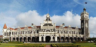
Dunedin railway station in Dunedin on New Zealand's South Island, designed by George Troup, is the city's fourth station. It earned its architect the nickname of "Gingerbread George".

George Street, Dunedin street in Otago Region, New Zealand

George Street is the main street of Dunedin, the second largest city in the South Island of New Zealand. It runs for two and a half kilometres north-northeast from The Octagon in the city centre to the foot of Pine Hill. It is straight and undulates gently as it skirts the edge of the hills to its northwest. South of The Octagon, Princes Street continues the line of George Street south-southwest for two kilometres.

New Zealand State Highway 1 road in New Zealand

State Highway 1 is the longest and most significant road in the New Zealand road network, running the length of both main islands. It appears on road maps as SH 1 and on road signs as a white number 1 on a red shield, but it has the official designations SH 1N in the North Island, SH 1S in the South Island.

Signal Hill (New Zealand)

Signal Hill is a prominent landform in the city of Dunedin, New Zealand. It is located close to, and due north of, the head of the Otago Harbour and reaches an elevation of 393 m (1289 ft). The suburbs Ravensbourne, St. Leonards, and Opoho lie on its southern, eastern, and northwestern flanks, respectively. To the northwest is North East Valley, the thalweg of Lindsay Creek, a tributary of the Water of Leith. The southernmost spur of Signal Hill, Logan Point, has been extensively quarried for road gravel. State Highway 88 skirts the foot of the hill close to the edge of the Otago Harbour.

Dunedin North Dunedin suburb

Dunedin North, also known as North Dunedin, is a major inner suburb of the New Zealand city of Dunedin, located 1.5 kilometres (0.93 mi) northeast of the city centre. It contains many of the city's major institutions, including the city's university, polytechnic, main hospital, and largest museum. Dunedin North's 2001 population was 7,047, including the university area.

St Leonards, Dunedin Suburb of the New Zealand city of Dunedin

St Leonards is a suburb of the New Zealand city of Dunedin. It is located close to the northern shore of the Otago Harbour and on the hilly slopes above the harbour. St Leonards is 8.5 kilometres (5.3 mi) northeast of Dunedin's city centre, between the small settlement of Burkes and Sawyers Bay. St Leonards was named by early settler David Carey for the birthplace of his wife, the English town of St Leonards-on-Sea, on the Sussex coast.

Sawyers Bay human settlement in New Zealand

Sawyers Bay is a suburb of the New Zealand city of Dunedin. It is located 3 kilometres (1.9 mi) to the southwest of Port Chalmers in a wide valley on the shore of Mussel Bay, 13 kilometres (8.1 mi) to the northeast of Dunedin city centre.

Opoho

Opoho is a suburb of the New Zealand city of Dunedin. It sits on the western flank of Signal Hill, New Zealand, 3 kilometres (1.9 mi) to the northeast of the city centre, overlooking North East Valley and the Dunedin Botanic Gardens.

Leith Saddle

Leith Saddle is a saddle between the sources of the Water of Leith and the Waitati River, approximately halfway between Dunedin's northern suburb of Pine Hill and the outlying settlement of Waitati. The saddle is a strategic point where the Dunedin Northern Motorway, part of State Highway 1 traverses a fragile alpine forest. Proposed road works to straighten a dangerous corner here conflict with conservation values. Water supply pipelines, and popular tramping and cycling routes also converge at the saddle.

Dunedin-Waitati Highway road in New Zealand

Dunedin-Waitati Highway, formerly called Dunedin Northern Motorway, is a two to four-lane limited-access road which provides the main route north from the city of Dunedin, New Zealand. Opened on 14 December 1957, it superseded the narrow and winding routes via Port Chalmers and Mount Cargill. The road is occasionally briefly closed by snowfall in winter.

Caledonian Ground

The Caledonian Ground, often simply known as "The Caley", is a major sports venue in the New Zealand city of Dunedin. It is primarily used for soccer and athletics, and has a capacity of 7,500.

References

  1. Dunedin traffic and road information, nztraffic.com. Retrieved 6 March 2012.
  2. "SH 88 Realignment Completed on Time." Dunedin City Council, 7 July 2011. Retrieved 6 March 2012.
  3. Haggart, M. "Realignment first stage of $65m infrastructure investment." Otago Daily Times, 8 July 2011. Retrieved 6 March 2012.
  4. Price, M. "Cycleway tops list of Dunedin roading issues." Otago Daily Times, 15 May 2009. Retrieved 6 March 2012.

Coordinates: 45°51′47″S170°34′00″E / 45.8631°S 170.5667°E / -45.8631; 170.5667

Geographic coordinate system Coordinate system

A geographic coordinate system is a coordinate system that enables every location on Earth to be specified by a set of numbers, letters or symbols. The coordinates are often chosen such that one of the numbers represents a vertical position and two or three of the numbers represent a horizontal position; alternatively, a geographic position may be expressed in a combined three-dimensional Cartesian vector. A common choice of coordinates is latitude, longitude and elevation. To specify a location on a plane requires a map projection.