Route
SH87 leaves SH1 at a junction at the southwestern end of the Dunedin Southern Motorway, immediately south of Mosgiel. It travels north through the town as its main street, Gordon Road, before heading west along the northern edge of the Taieri Plain. The highway climbs the northeastern flank of Maungatua shortly after passing through Outram (where it crosses the Taieri River), its course becoming northwesterly. The course continues past the small settlements of Lee Stream and Clarks Junction before turning northeastward to head along the broad Strath-Taieri valley. After passing through Sutton, the highway reaches the town of Middlemarch.

State Highway 1 is the longest and most significant road in the New Zealand road network, running the length of both main islands. It appears on road maps as SH 1 and on road signs as a white number 1 on a red shield, but it has the official designations SH 1N in the North Island, SH 1S in the South Island.

The Dunedin Southern Motorway is the main arterial route south from the South Island city of Dunedin, part of New Zealand's State Highway 1. It is one of the world's southernmost motorways.
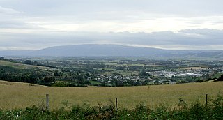
The Taieri Plain is an area of fertile agricultural land to the southwest of Dunedin, in Otago, New Zealand. The plain covers an area of some 300 square kilometres, with a maximum extent of 30 kilometres.
From Sutton, the highway runs close to the course of the Taieri River, and from Middlemarch the Otago Central Rail Trail also runs nearby. The highway continues northeast past Hyde before emerging onto the high Maniototo plain. The highway terminates at Kyeburn, 15 km to the east of Ranfurly, at a junction with SH85.
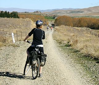
The Otago Central Rail Trail is a 150-kilometre walking, cycling and horse riding track in the South Island of New Zealand. A pioneering project for New Zealand, the successful cycle trail joined the New Zealand Cycle Trail umbrella organisation in 2012, having been one of the inspirations for it.

Hyde is a locality in Otago, New Zealand, located in the Strath-Taieri. It is close to the northern end of the Rock and Pillar Range on State Highway 87 between Middlemarch and Ranfurly.

The Maniototo Plain, usually simply known as The Maniototo, is an elevated inland region in Otago, New Zealand. The region roughly surrounds the upper reaches of the Taieri River and the Manuherikia River. It is bounded by the Kakanui Range to the north and the Rock and Pillar Range to the southeast. It has a harsh, dry climate, ranging from over 30 °C in mid-summer to -15 °C in mid-winter.
This page is based on this
Wikipedia article Text is available under the
CC BY-SA 4.0 license; additional terms may apply.
Images, videos and audio are available under their respective licenses.
Middlemarch is a small town in the Otago region of New Zealand's South Island. It lies at the foot of the Rock and Pillar Range of hills in the broad Strath-Taieri valley, through which flows the middle reaches of the Taieri River. Since local government reorganisation in the late 1980s, Middlemarch and much of the Strath-Taieri has been administered as part of Dunedin city, the centre of which lies some 80 km to the southeast. Middlemarch has reticulated sewerage but no reticulated water supply.

The Taieri River is the fourth-longest river in New Zealand and is in Otago in the South Island. Rising in the Lammerlaw ranges, it initially flows north, then east around the Rock and Pillar range before turning southeast, reaching the sea 30 kilometres (19 mi) south of Dunedin.

The Dunedin Railways is an operator of a railway line and tourist trains based at Dunedin Railway Station in the South Island of New Zealand. The railway is a council-controlled trading organisation owned jointly by the Dunedin City Council and the Otago Excursion Train Trust.
Strath Taieri is a large glacial valley and river plateau in New Zealand's South Island. It is surrounded by the rugged hill ranges to the north and west of Otago Harbour. Since 1989 it has been part of the city of Dunedin. The small town of Middlemarch is located at its southern end.
Danseys Pass is a mountain pass located in the Kakanui Mountains, between Central Otago and North Otago, in the South Island of New Zealand.

Outram is a rural suburb of Dunedin, New Zealand, with a population of 642. It is located 28 kilometres west of the central city at the edge of the Taieri Plains, close to the foot of Maungatua. The Taieri River flows close to the southeast of the town. Outram lies on State Highway 87 between Mosgiel and Middlemarch.
The Rock and Pillar Range of high hills is located in the Maniototo, an area of inland Otago, New Zealand. They are surrounded by the Taieri River, which has its source in the range, flowing out across the scroll plain at Paerau, before almost doubling back on itself at Waipiata and flowing back along the other side through the Strath-Taieri. The town of Middlemarch lies close to the Taieri to the east of the range, and Patearoa lies to the northwest.

The Otago Central Railway (OCR) or in later years Otago Central Branch Railway, now often referred to as the Taieri Gorge Railway, was a secondary railway line in Central Otago, in the South Island of New Zealand.

State Highway 8 is one of New Zealand's eight national highways. It forms an anticlockwise loop through the southern scenic regions of the Mackenzie Basin and Central Otago, starting and terminating in junctions with State Highway 1. Distances are measured from north to south.

State Highway 85 is a South Island state highway in New Zealand, servicing the Maniototo Plains and the North and Central Otago regions of the South Island between the major settlements of Alexandra and Palmerston. It is wholly two lane and passes through some of the most extreme climatic regions in New Zealand. The highway is known colloquially as "The Pigroot". Though there is no definitive explanation for this name, A. W. Reed, in his book Place Names of New Zealand, mentions an incident during John Turnbull Thomson's survey of inland Otago in which local wild pigs were so unafraid of humans that a huge boar approached his party and rubbed its nose against that of Thomson's horse.
Kyeburn is a small settlement in Otago, in the South Island of New Zealand. It lies on the Maniototo, a wide, high plain stretching from the end of the Strath-Taieri valley.
Sutton is a locality in the Strath Taieri, in the southern part of South Island, New Zealand. It is located on SH 87 close to the point where it is met by the Taieri Gorge rail line, some 5 kilometres to the south of Middlemarch. New Zealand's only salt lake, the Sutton Salt Lake, lies 10 kilometres to the west.


