New Zealand State Highway 52

Last updated

State Highway 52 NZ.svg

State Highway 52
Route information
Maintained by Central Hawke's Bay District Council, Tararua District Council, Masterton District Council
Major junctions
North end State Highway 2 NZ.svg at Waipukurau
South end State Highway 2 NZ.svg at Masterton
Location
Primary
destinations
Porangahau, Weber, Pongaroa
Highway system
State Highway 50 NZ.svg SH 50 SH 53 State Highway 53 NZ.svg
Route 52 Road Sign (8539601449).jpg

State Highway 52 is a former state highway now reclassified Route 52. It runs from Waipukurau, Central Hawkes Bay, to Masterton in the Wairarapa through Porangahau on the east coast and the Weber and Pongaroa hill country on the lower eastern side of the North Island. [1]

Waipukurau Minor urban area in Hawkes Bay, New Zealand

Waipukurau is the largest town in the Central Hawke's Bay District on the east coast of the North Island of New Zealand. It is located on the banks of the Tukituki River, 7 kilometres south of Waipawa and 50 kilometres southwest of Hastings.

Masterton Territorial authority in Wellington, New Zealand

Masterton is a large town in the Wellington Region of New Zealand and the seat of the Masterton District. It is the largest town in the Wairarapa, a region separated from Wellington by the Rimutaka ranges. It is 100 kilometres north-east of Wellington, 39.4 kilometres south of Eketahuna, on the Ruamahanga River.

Porangahau Place in New Zealand

Porangahau, a township close to the Pacific Ocean coast in the south-east of the North Island of New Zealand, has a very small population. It lies in the southernmost part of Hawke's Bay, 45 kilometres south of Waipukurau, and close to the mouth of the Porangahau River. There is a marae at Porangahau.

Contents

History

Route 52 runs south through southern Hawkes Bay and the Tararua District to the Wairarapa passing through the coastal side of the one-time very dense forest of the Seventy Mile Bush, known at its southern end as the Forty Mile Bush.

Tararua District Territorial authority in Manawatu-Wanganui, New Zealand

The Tararua District is an area near the south-east corner of New Zealand's North Island that is administered by the Tararua District Council. It has a population of 17,900, and an area of 4,360.56 km². The Tararua District Council was created by the amalgamation of the Dannevirke District Council, Eketahuna County Council, Pahiatua Borough Council, Pahiatua County Council and Woodville District Council in the 1989 local government reforms.

Wairarapa region in New Zealand

Wairarapa, is a geographical region of New Zealand. It occupies the south-eastern corner of the North Island, east of metropolitan Wellington and south-west of the Hawke's Bay region. It is lightly populated, having several rural service towns, with Masterton being the largest. It is named after its largest lake, Lake Wairarapa.

Seventy Mile Bush

The Seventy Mile Bush was a heavily forested area of New Zealand extending from Wairarapa to Central Hawkes Bay and out to that coast. It was cleared and settled by Scandinavians, assisted immigrants in the 1870s. On arrival they walked from the surrounding coastal settlements to cut down the forest and clear the land for farming. The land was not as described to them. Without funds for a return passage they were obliged to remain.

Waipukurau to Porangahau

The 26 miles of road was approved by Provincial Council in April 1859 and constructed over the next year [2] but, five years later, passage was still difficult. [3]

Porangahau to Weber

By 1864 a road reached Wainui — renamed Herbertville in 1889 — though bridges still had to be made. [4] A separate Weber Road Board was established in 1890, an offshoot of the Porangahau Road Board. [5]

Weber Pongaroa Alfredton
Pongaroa, January 2015
built 1902 Postal, Pongaroa, New Zealand (16200790167).jpg
Pongaroa, January 2015
built 1902
Biking Route 52, New Zealand (8522904931).jpg

Sections in the settlement of Pongaroa were offered for sale in March 1895. [7] Roadwork ceased for the winter in June 1895 with 2½ miles of road formed. [8] By the end of May the Minister of Lands had ordered signs banning bullocks from working between Falls creek and Pongaroa stream, between 1 June and 1 November. [9] Some account follows of the battle to make this section of the road.

Pongaroa human settlement in New Zealand

Pongaroa is a town in the Tararua District, in the southeast of the North Island of New Zealand, 110 kilometres southwest of Hastings and 200 kilometres northeast of Wellington. The nearest town is Pahiatua, 50 kilometres to the west. Popular Akitio Beach is 30 kilometres to the east. The township straddles Route 52, a road between Masterton and Waipukurau.

John O'Meara successfully campaigned for the Pahiatua seat in the 1896 general election. Part of his platform was that land should be roaded before new settlers were obliged to live on that land to keep their title. At an election meeting in Woodville he claimed to have never before seen such a place as the road between Pongaroa and Weber. Nineteen (pack)horses had been lost on that road that winter. [10] In January it was announced roadworks at Pongaroa would recommence around the end of the month. [11] Six parties of "co-operative labourers" duly began forming the road between Makuri and Pongaroa before the month was out. [12]

John OMeara (politician) New Zealand politician

John O'Meara was a Liberal Party Member of Parliament in New Zealand.

Pahiatua is a former New Zealand parliamentary electorate in the Wairarapa region. It existed from 1896 to 1996, and was represented by nine Members of Parliament, including Prime Minister Keith Holyoake for 34 years.

Shipping wool from Akitio beach. The bullock team will take the dray into water deep enough for the wool to be loaded onto a boat then rowed to the steamer Shipping wool at Akitio crop.jpg
Shipping wool from Akitio beach. The bullock team will take the dray into water deep enough for the wool to be loaded onto a boat then rowed to the steamer

In June the Ashburton Guardian said the road to Pongoroa is so bad it takes fourteen bullocks to haul just two tons to the township. [13] While passable by a light vehicle in summer in winter or after heavy rain the banks slipped and the road had to be made over and over again. The same geological structure brought complaints from settlers that the ground did not drain properly and counter to its appearance had low fertility. [14]

By 1903 the roading position had improved to the point where the major concern was what proportions of the cost should be borne by central government and the Road Board's ratepayers.

Alfredton in the Moroa to Masterton

A route was surveyed by the Provincial Engineer in 1866. [15] There was pressure from ratepayers to limit new roads to those leading to the coast (Castlepoint) on the grounds that sea transport was more economical and roads were used once-weekly by coach services considered "the luxury of wealthy squatters". [16] However, by May 1885 a local newspaper was able to report the completion of the 80 foot span of the bridge over the Ihuraua river and described the new bridge as the key to the Alfredton and Tiraumea districts. [17]

Downgrade

Shipping wool from the East Coast near East Cape, the steamer waits, the shallow draft boat in a flooded creek is almost hidden by the horses on the creek's bank Shipping wool at Te Araroa, East Coast (21635590846) (cropped).jpg
Shipping wool from the East Coast near East Cape, the steamer waits, the shallow draft boat in a flooded creek is almost hidden by the horses on the creek's bank

Route 52, upgraded to a State Highway about 1960, lost its state highway status because usage did not grow but fell away as prosperity deserted New Zealand's farming industry. Farmers shed staff and cut back development. Farming districts became depopulated and the intervening settlements failed to grow. Nevertheless, Route 52 remains the only road access to large areas of highly productive hill country farmland.

Once serviced by coastal steamers remote areas like Akitio and Herbertville are accessed through Route 52's links to State Highway 2.

Because of its scenic qualities it is now a cycle touring route and noted by some as one of the must drive roads in New Zealand. The road is relatively narrow and winds through steep hill country. Wandering livestock and stock trucks are hazards. [18] [19]

Route

Hill country farmland near Tiraumea, Tararua mountain range backdrop Tararuas from Pori Rd., Wairarapa, New Zealand, August 2008 (2783466324).jpg
Hill country farmland near Tiraumea, Tararua mountain range backdrop
Southern Hawke's Bay Cycling Route 52 North Island New Zealand (8524004952).jpg
Southern Hawke's Bay

Route 52 leaves Waipukurau at its intersection with SH 2. From there it passes through numerous small farm settlements. Heading south-east the highway goes to the coastline at Porangahau through Wanstead and Wallingford where it turns back inland in a SSW direction. From there it passes through Weber, Waione, Pongaroa, and Tiraumea before heading west to Alfredton. From Alfredton it heads in more southerly direction to Ihuraua along Whangaehu Valley Road to Lansdowne, Masterton.

Taumata

A few kilometres south of Porangahau Route 52 passes a hill with one of the world's longest place names, Taumatawhakatangihangakoauauotamateapokaiwhenuakitanatahu. A Maori word meaning "The place where Tamatea, the man with the big knees, who slid, climbed and swallowed mountains, known as 'landeater', played his flute to his loved one".

Major intersections

Territorial authority Location km Destinations Notes
Central Hawke's Bay District Waipukurau 0 State Highway 2 NZ.svg SH 2 south (Ruataniwha Street)
Dannevirke, Wellington
State Highway 2 NZ.svg SH 2 north (Herbert Street)
Hastings, Napier
Route 52 begins
Intersection of Racecourse Road and Porangahau Road
Porangahau Intersection of Porangahau and Wimbledon Roads
Intersection of Wimbledon Road and Birch Road East
Tararua District Wimbledon Intersection of Wimbledon and Herbertville Roads, and Route 52
Weber Intersection of Route 52 and Weber Road
Waione Intersection of Route 52 and River Road
Pongaroa Township
Intersection of Gandys Road and Route 52
Tiraumea Intersection of Haunui Road and Route 52
Intersection of Pa Valley Road and Route 52
Alfredton Intersection of Castle Hill Road and Route 52
Intersection of Alfredton Road and Route 52 Route 52 turns left at this intersection
Ihuraua Intersection of Bartons Line and Route 52
Masterton District Dreyers Rock Intersection of Dreyers Rock Road, Route 52, and Whangaehu Valley Road Route 52 follows Whangaehu Valley Road
Whangaehu Intersection of Whangaehu Valley and Te Ore Ore — Bideford Roads Route 52 turns right into Te Ore Ore — Bideford Road
Te Ore Ore Intersection of Te Ore Ore — Bideford, Te Ore Ore, and Masterton — Castlepoint Roads Route 52 turns right into Te Ore Ore Road
Masterton State Highway 2 NZ.svg SH 2 south (Opaki Road)
Carterton, Wellington
State Highway 2 NZ.svg SH 2 north (Opaki Road)
Eketahuna, Woodville, Napier
Route 52 ends

See also

Related Research Articles

Hawkes Bay Region region on the east coast of New Zealands North Island

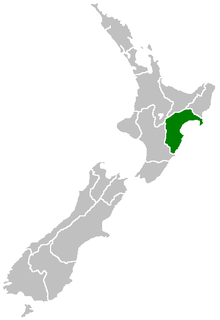
Hawke's Bay Region is a region of New Zealand on the east coast of the North Island. It is governed by Hawke's Bay Regional Council, which sits in the city of Napier. The region's name derives from Hawke Bay, which was named by Captain James Cook in honour of Admiral Edward Hawke.

Central Hawkes Bay District Territorial authority in Hawkes Bay, New Zealand

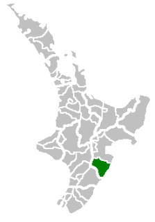
Central Hawke's Bay District is part of the Hawke's Bay Region in the North Island of New Zealand. It has an area of 3,327.92 square kilometres with a population of 14,150. It had a population of 12,717 people as of the 2013 census. This is a decrease of 237 people, or 1.8 percent, since the 2006 Census. It covers the area from Pukehou in the north to Takapau in the south, and from the western Ruahine Range to the Pacific coast in the east.

Woodville, New Zealand Place in Manawatu-Wanganui, New Zealand

Woodville, previously known as The Junction is a small town in the southern North Island of New Zealand, 75 km north of Masterton and 25 km east of Palmerston North. The 2013 census showed that 1401 people reside in Woodville.

Wairarapa Line

The Wairarapa Line is a secondary railway line in the south-east of the North Island of New Zealand. The line runs for 172 kilometres (107 mi), connects the capital city Wellington with the Palmerston North - Gisborne Line at Woodville, via Lower Hutt, Upper Hutt and Masterton.

Wairarapa Bush Rugby Football Union

The Wairarapa Bush Rugby Football Union is the body that regulates rugby union in Masterton, New Zealand. It was formed in 1971 with the amalgamation of the Wairapapa and Bush Unions.

The Wairarapa Mail was a passenger train operated by the New Zealand Railways Department (NZR) between Wellington and Woodville, continuing on to Palmerston North as a mixed train. It ran from 1909 until 1948 and its route included the famous and arduous Rimutaka Incline.

Wairarapa (New Zealand electorate) New Zealand electorate

Wairarapa is a New Zealand parliamentary electorate. It was first created in 1858 and existed until 1881. It was recreated in 1887 and has since existed continuously. In the early years, the electorate was for a time represented by two members. Wairarapa has been held by Alastair Scott since the 2014 election.

Weber, New Zealand Hamlet in New Zealand

Weber is a hamlet situated 28 km south-east of Dannevirke and 23 km WNW of Herbertville, on the east coast of New Zealand. It is about 5 km south of Waipatiki. Weber was named after the German born surveyor Charles H. Weber (*1830) who died during a surveying project near Woodville in 1886. His body was only found three years after his disappearance.

The Palmerston North–Gisborne Line (PNGL) is a secondary main line railway in the North Island of New Zealand. It branches from the North Island Main Trunk Railway in Palmerston North and runs east through the Manawatu Gorge to Woodville, where it meets the Wairarapa Line, and then proceeds to Hastings and Napier in Hawke's Bay before following the coast north to Gisborne. Construction began in 1872, but the entire line was not completed until 1942.

Woodville railway station, Manawatu-Wanganui railway station in New Zealand

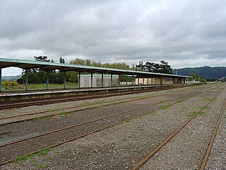
Woodville railway station is the northern terminus of the Wairarapa Line and is located at the junction with the Palmerston North - Gisborne Line in the small Tararua town of Woodville, 27 km (17 mi) east of Palmerston North in New Zealand's North Island.

The Bush Rugby Football Union is a former provincial rugby union team from New Zealand, existing between 1890 and 1971.

Wairarapa and Hawke's Bay is a former parliamentary electorate in the Wellington region of New Zealand, from 1853 to 1859, when it was extended into previously unincorporated territories, split in two and replaced by County of Hawke with its southern portion being the newly created Wairarapa electorate. It is the first general electorate to have been abolished in New Zealand.

The 1858 Wairarapa and Hawke's Bay by-election was a by-election held in the Wairarapa and Hawke's Bay electorate during the 2nd New Zealand Parliament, on 22 July 1858.

1934 Pahiatua earthquake

The 1934 Pahiatua earthquake struck at 11:46 pm on 5 March, causing severe damage in much of the lower North Island. Wairarapa, Wellington and Hawke's Bay felt the strongest levels of shaking, with much of New Zealand feeling the tremor.

1904 Cape Turnagain earthquake

The 1904 Cape Turnagain earthquake struck 10 kilometres (6.2 mi) north of Cape Turnagain on the morning of 9 August with a magnitude estimated at 6.8 Ms and 7.0–7.2 Mw It was felt throughout the North Island and upper South Island, with many communities within a 500 kilometres (310 mi) radius reporting noticeable ground shaking. Heavy damage occurred to the landscape and personal property and one man died. It was the largest to strike New Zealand since the 7.0 Mw  North Canterbury earthquake in 1888.

References

  1. "TeAra, Wairarapa Region," . Retrieved 4 February 2016.
  2. Thursday, May 12, Hawke's Bay Herald, Volume 2, Issue 87, 21 May 1859, Page 3 retrieved 17 December 2015
  3. Report upon Roads. Hawke's Bay Herald, Volume 7, Issue 513, 23 July 1864, Page 1
  4. Report upon Roads, Hawke's Bay Herald, Volume 7, Issue 513, 23 July 1864, Page 1
  5. Bush Advocate, Volume IV, Issue 278, 20 February 1890, Page 2
  6. Pongaroa, Woodville Examiner, Volume XX, Issue 3400, 30 April 1902, Page 3
  7. Wanganui Herald, Volume XXIX, Issue 8446, 15 January 1895, Page 4
  8. Pongaroa Woodville Examiner, Volume XIII, Issue 2383, 24 June 1895, Page 4
  9. Pongaroa. Woodville Examiner, Volume XIII, Issue 2376, 7 June 1895, Page 2
  10. Mr O'Meara at Woodville Woodville Examiner, Volume XIV, Issue 2588, 30 October 1896, Page 2
  11. Local and General, Wairarapa Daily Times, Volume XVI, Issue 5536, 18 January 1897, Page 2
  12. Local and General. Woodville Examiner, Volume XIV, Issue 2613, 27 January 1897, Page 2
  13. Local and General. Ashburton Guardian, Volume XVIII, Issue 4271, 18 August 1897, Page 2
  14. Pongaroa. Woodville Examiner, Volume XVII, Issue 2906, 11 January 1899, Page 3
  15. Report of the chief engineer on road tracks, Manawatu to Moroa and Seventy-mile Bush. Wellington Independent, Volume XXII, Issue 2530, 11 June 1867, Page 4
  16. Roads in the Castlepoint district Wairarapa Daily Times, Volume 2, Issue 366, 17 January 1880, Page 2
  17. Alfredton, Wairarapa Daily Times, Volume VII, Issue 1999, 26 May 1885, Page 2
  18. "The 10 NZ roads you must drive" . Retrieved 4 February 2016.
  19. "Route 52, New Zealand Cycleways" . Retrieved 4 February 2016.