State Highway 1 is the longest and most significant road in the New Zealand road network, running the length of both main islands. It appears on road maps as SH 1 and on road signs as a white number 1 on a red shield, but it has the official designations SH 1N in the North Island, SH 1S in the South Island.
The Ngauranga Interchange is a major interchange in the suburb of Ngauranga, in Wellington City, New Zealand. The Ngauranga interchange connects State Highways 1 and 2 with each other and also to Hutt Road for access to the interisland ferry terminals and alternative access to Wellington City. The majority of traffic in and out of Wellington City uses this interchange.

State Highway 30 (SH 30) is a New Zealand state highway, linking the Waikato and Bay of Plenty towns of Te Kuiti, Mangakino, Rotorua, and Whakatane.
The Tauranga Eastern Link (TEL) is a four lane motorway in the Bay of Plenty region in New Zealand, covering 23 km from Te Maunga junction in Tauranga to Paengaroa. It was officially opened on 30 July 2015. It replaced a section of State Highway 2, improving access to Tauranga from the east and south. It became the main route for trucks heading to the Port of Tauranga from Rotorua and the eastern Bay of Plenty, and connected the Central Plateau forestry industry with the port to facilitate lumber export.
State Highway 73 is a major east-west South Island state highway in New Zealand connecting Christchurch on the east coast with Cass/Hokitika via the Southern Alps. It is mostly two lane, with some single-lane bridges north of Springfield but is mostly dual carriageway in Christchurch. The fourth and fifth-highest points of New Zealand's state highway network are on this road at Porters Pass and Arthur's Pass respectively.
State Highway 74 is a state highway in New Zealand servicing the eastern suburbs of Christchurch. Mostly two-lane, it is composed of limited-access expressways, with part of the highway as the Christchurch-Lyttelton Motorway, and connects the city to its port town of Lyttelton.
State Highway 77 is a state highway in New Zealand going through the inland parts of Central and Mid Canterbury between the towns of Ashburton and Darfield via the Rakaia Gorge. It is wholly single carriageway with two one-lane bridges at the Rakaia and Selwyn Rivers. One set of traffic lights is found in Ashburton marking the southern terminus of the highway.

State Highway 57 is a New Zealand state highway, linking State Highway 1 north of Ohau to State Highway 3 east of Ashhurst, via Levin, Shannon, Massey University and the southern suburbs of Palmerston North. The highway connects State Highway 1 traffic coming north from Wellington to the city of Palmerston North, and further to the Manawatu Gorge, allowing passage to the eastern side of the North Island and to the twin cities of Napier and Hastings. The highway is classified by the NZTA as a national strategic road.
State Highway 11 (SH 11) is a 30 kilometre stretch of highway in the North Island of New Zealand. It links SH 10 at Puketona and SH 1 at Kawakawa. Its main destination is the Bay of Islands township of Paihia. Until 2004, it terminated at Tohitapu Road, in southern Paihia township.
State Highway 22 (SH 22) is a New Zealand state highway just south of Auckland. It connects the town of Pukekohe to the Auckland Southern Motorway.
State Highway 28 (SH 28) is a New Zealand state highway in the Waikato region. The highway was gazetted in 1997 as a faster route for traffic travelling between SH 1 and SH 29 towards the Port of Tauranga. Prior to the formation of SH 28 the quickest route, only if using state highways, was via Tirau and SH 27. There are no towns on this route and due to the highway being mapped to existing rural roads there are several places were motorists need to give way to traffic from other roads.
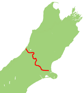
State Highway 35 (SH 35) is a New Zealand state highway on the East Coast of the North Island. It is the main highway that services the East Cape of New Zealand as well as many other rural towns such as Hicks Bay, Ruatoria, Tolaga Bay, and the city of Gisborne.
State Highway 25 is a North Island state highway in New Zealand that loops around the Coromandel Peninsula. It is a major route for holidaymakers and tourists which has access to some of New Zealand's most idyllic beach holiday spots. The summer period around Christmas and New Year's Eve is a particularly busy period for the highway. The road is very scenic, but also windy in many parts as well as single carriage on the entire route, and is prone to accidents. It is New Zealand's third longest two-digit state highway, after SH 35 and SH 94. It is part of the Pacific Coast Highway.
State Highway 39 (SH 39) is a New Zealand state highway that forms a western bypass of the city of Hamilton. Gazetted in 1999, it is a generally quicker route to get between Auckland and New Plymouth as well as connecting to the Waitomo Caves, just south of the SH 39 southern terminus. The southernmost 14 km section has a concurrency with SH 31, as this highway has existed for much longer.
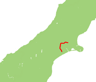
State Highway 33 (SH 33) is a New Zealand state highway in the Bay of Plenty in the North Island. It is one of two state highways that form a north-south connection between the cities of Tauranga and Rotorua, SH 33 being the most easterly of the two.
State Highway 36 (SH 36) is a New Zealand state highway in the Bay of Plenty region in the North Island. It is one of two state highways that form a north-south connection between the cities of Tauranga and Rotorua, SH 36 being the most westerly of the two. It was identified as a quicker route to access the two cities and extensive work was done to upgrade the rural route to state highway quality.