New Zealand State Highway 83

Last updated

State Highway 83 NZ.svg

State Highway 83
NZ-SH83 map.png
Route information
Maintained by NZ Transport Agency
Length 109.4 km (68.0 mi)
Major junctions
From Omarama Avenue State Highway 8 NZ.svg at Omarama
To Hilderthorpe Pukeuri Road/Pukeuri Oamaru Road State Highway 1 NZ.svg at Pukeuri
Location
Primary
destinations
Otematata, Kurow, Duntroon.
Highway system
State Highway 82 NZ.svg SH 82 SH 84 State Highway 84 NZ.svg

State Highway 83 is a South Island state highway in New Zealand running up the Waitaki Valley between the settlements of Pukeuri and Omarama. It forms part of the southernmost of the east-west roads crossing the South Island (via Haast Pass).

South Island Southernmost of the two main islands in New Zealand

The South Island, also officially named Te Waipounamu, is the larger of the two major islands of New Zealand in surface area; the other being the smaller but more populous North Island. It is bordered to the north by Cook Strait, to the west by the Tasman Sea, and to the south and east by the Pacific Ocean. The South Island covers 150,437 square kilometres (58,084 sq mi), making it the world's 12th-largest island. It has a temperate climate.

The New Zealand state highway network is the major national highway network in New Zealand. Nearly 100 roads in the North and South Islands are state highways. All state highways are administered by the NZ Transport Agency.

Waitaki River river in New Zealand

The Waitaki River is a large braided river that drains the Mackenzie Basin and runs some 110 kilometres (68 mi) south-east to enter the Pacific Ocean between Timaru and Oamaru on the east coast of the South Island of New Zealand. It starts at the confluence of the Ohau River and the Tekapo River, now in the head of the artificial Lake Benmore, these rivers being fed by three large glacial lakes, Pukaki, Tekapo, and Ohau. The Waitaki flows through Lake Benmore, Lake Aviemore and Lake Waitaki, these lakes being contained by hydroelectric dams, Benmore Dam, Aviemore Dam and Waitaki Dam. The Waitaki has several tributaries, notably the Ahuriri River and the Hakataramea River. It passes Kurow and Glenavy before entering the Pacific Ocean.

Contents

Route

Since designation, this is the route SH 83 takes.

As Chain Hills Highway, it begins in Omarama and passes through most of the settlement in an easterly direction. Leaving Omarama, the road changes name to Omarama Otematata Road. The road then runs along the banks of the Ahuriri Arm of Lake Benmore and descends into the township of Otematata (turnoff for the Benmore Dam). After Otematata, the road then passes along the southern banks of Lakes Aviemore and Waitaki as well as their respective dams.

Omarama Township in Canterbury, New Zealand

Omarama is a small township at the junction of State Highways 8 and 83, near the southern end of the Mackenzie Basin, in the South Island of New Zealand. Omarama is in the Waitaki District, in the southern Canterbury region. The Ahuriri River is a short distance to the north of the township.

Ahuriri River river

The Ahuriri River is a river in the Otago region of the South Island of New Zealand.

Lake Benmore reservoir

Lake Benmore is a lake located in the South Island of New Zealand. It was artificially created in the 1960s by construction of Benmore Dam. The lake covers an area of approximately 75 km². Parts of it lie in the Mackenzie, Waimate, and Waitaki districts within the southern portion of the Canterbury Region.

The road emerges on the upper Waitaki River floodplain and enters the township of Kurow. Beyond Kurow, the road is all but flat and runs along the southern flanks of the floodplains as well as through Duntroon and Georgetown before crossing a low saddle to descend into Pukeuri.

Kurow Rural centre in Canterbury, New Zealand

Kurow is a small town in the Waitaki District, New Zealand. It is located on the south bank of the Waitaki River, 60 kilometres (37 mi) northwest of Oamaru. At the 2013 Census, the town had a population of 312 people.

Duntroon, New Zealand Town in Canterbury, New Zealand

Duntroon is a small farming-town in the Waitaki District of New Zealand's South Island. Although traditionally considered a North Otago town, it is located as of 2018 within the farthest southern reaches of Canterbury. Just north of the town runs the Waitaki River, which forms the traditional border between the two regions, although the official border has moved south to put most of Waitaki District within Canterbury, including Duntroon. To the east of the village runs the Maerewhenua River. Near the village are the Earthquakes, a limestone-cliff formation.

Georgetown is a suburb of New Zealand's southernmost city, Invercargill.

Images

See also

Related Research Articles

Benmore Dam

Benmore Dam is the largest dam within the Waitaki power scheme, located in the Canterbury Region of New Zealand's South Island. There are eight other power stations in the Waitaki Power Scheme.

North Otago

The district of North Otago in New Zealand covers the area of Otago between Shag Point and the Waitaki River, and extends inland to the west as far as the village of Omarama.

Mackenzie Basin drainage basin

The Mackenzie Basin is an elliptical intermontane basin located in the Mackenzie and Waitaki Districts, near the centre of the South Island of New Zealand. It is the largest such basin in New Zealand. Historically famous mainly for sheep farming, the sparsely populated area is now also a popular tourism destination.

Twizel Place in Canterbury, New Zealand

Twizel is the largest town in the Mackenzie District, in the Canterbury Region of New Zealand's South Island. The town was founded in 1968 to house construction workers on the Upper Waitaki Hydroelectric Scheme. Twizel has a resident population of 1,280 ; during the summer, holidaymakers nearly triple the town's population.

Lake Aviemore reservoir in New Zealand

Lake Aviemore or Mahi Tikumu is a man-made lake in New Zealand's South Island, part of the Waitaki hydroelectric scheme. Immediately upstream is Lake Benmore and downstream Lake Waitaki. Aviemore lies on both sides of the border between the Waimate and Waitaki districts.

Otematata Village in Canterbury, New Zealand

Otematata is a village in the Waitaki District of Canterbury in New Zealand's South Island. It is defined as a "populated area less than a town" and the 2001 New Zealand census gave the "usually resident population count" as 243. By the 2006 census it had declined to 189 inhabitants. This was considerably higher in the 1960s during the construction of the Benmore and Aviemore dams.

New Zealand State Highway 1 road in New Zealand

State Highway 1 is the longest and most significant road in the New Zealand road network, running the length of both main islands. It appears on road maps as SH 1 and on road signs as a white number 1 on a red shield, but it has the official designations SH 1N in the North Island, SH 1S in the South Island.

The Kurow Branch was part of New Zealand's national rail network. In the North Otago region of the South Island, it was built in the 1870s to open up the land behind Oamaru for development, and closed in 1983.

Pukeuri human settlement in New Zealand

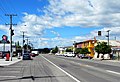
Pukeuri is a settlement to the north of Oamaru in the North Otago region of New Zealand's South Island. It is located near the coast in the Waitaki District that straddles the border of Otago and Canterbury. According to the 2001 census, it has a usually resident population of 183; 99 males and 84 females, a decline of 21 people or 10.3% since the 1996 census. The settlement's major employer is the Alliance abattoir, which is North Otago's biggest employer. A large fire in January 2006 came at the height of the killing season and caused significant disruptions for both workers and customers.

Hakataramea human settlement in New Zealand

Hakataramea, spelt Hakateramea in some older sources, is a rural village located in the southern Canterbury region of New Zealand's South Island. It is in the Waimate District and sits on the north bank of the Waitaki River at its confluence with the Hakataramea River.

New Zealand State Highway 8 road in New Zealand

State Highway 8 is one of New Zealand's eight national highways. It forms an anticlockwise loop through the southern scenic regions of the Mackenzie Basin and Central Otago, starting and terminating in junctions with State Highway 1. Distances are measured from north to south.

New Zealand State Highway 30 road in New Zealand

State Highway 30 (SH 30) is a New Zealand state highway, linking the Waikato and Bay of Plenty towns of Te Kuiti, Mangakino, Rotorua, and Whakatane.

Alps to Ocean Cycle Trail New Zealand cycling and tramping trail

The Alps 2 Ocean Cycle Trail is a cycle trail funded as one of the projects of the New Zealand Cycle Trail. The trail extends more than 300 kilometres (190 mi) from Aoraki / Mount Cook to Oamaru on the Pacific Ocean. Suitable for all ages, the trail is an easy grade, and offers a mix of on and off-road trails.

New Zealand State Highway 82 road in New Zealand

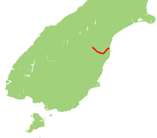
State Highway 82 (SH 82) is a minor east-west South Island state highway in South Canterbury connecting SH 1 at the locality of Hook to SH 83 at the settlement of Kurow in the Waitaki Valley via the major town of Waimate. It is a two lane single carriageway.

State Highway 41 (SH 41) is a New Zealand state highway in the central North Island that runs from Manunui, just south of Taumarunui on SH 4 to Turangi just north of the Desert Road. It compromises part of the western bypass of Lake Taupo along with SH 32.

References