New Zealand State Highway 77

Last updated

State Highway 77 NZ.svg

State Highway 77
NZ-SH 77 map.png
Route information
Maintained by NZ Transport Agency
Length 93.9 km (58.3 mi)
Tourist
routes
Inland Scenic Route between Homebush and Mount Hutt
Major junctions
Northwest end South Terrace/West Coast Road State Highway 73 NZ.svg at Darfield
Southeast end West Street State Highway 1 NZ.svg at Ashburton
Location
Primary
destinations
Coalgate, Glentunnel, Rakaia Gorge, Methven
Highway system
State Highway 76 NZ.svg SH 76 SH 78 State Highway 78 NZ.svg

State Highway 77 is a state highway in New Zealand going through the inland parts of Central and Mid Canterbury between the towns of Ashburton and Darfield via the Rakaia Gorge. It is wholly single carriageway with two one-lane bridges at the Rakaia and Selwyn Rivers. One set of traffic lights is found in Ashburton marking the southern terminus of the highway.

The New Zealand state highway network is the major national highway network in New Zealand. Nearly 100 roads in the North and South Islands are state highways. All state highways are administered by the NZ Transport Agency.

Canterbury, New Zealand Region of New Zealand in South Island

Canterbury is a region of New Zealand, located in the central-eastern South Island. The region covers an area of 44,508 square kilometres (17,185 sq mi), and is home to a population of 624,000.

Ashburton, New Zealand Secondary urban area in Canterbury, New Zealand

Ashburton is a large town in the Canterbury Region, on the east coast of the South Island of New Zealand. The town is the seat of the Ashburton District, a territorial authority encompassing the town and a number of small settlements within its surrounding rural area, roughly coterminous with the subregion of Mid Canterbury. It is 85 kilometres (53 mi) south west of Christchurch and is sometimes regarded as a satellite town of Christchurch.

Contents

About 43 km of the highway lie on the Inland Scenic Route (formerly State Highway 72).

The Inland Scenic Route is a touring route in Canterbury, New Zealand. In the north, the route starts in Rangiora and in the south, it ends at Orari Bridge where it meets State Highway 79 (SH 79). It is on the New Zealand Automobile Association's list of 101 things that "Kiwis must do". The Inland Scenic Route is a former state highway, but this designation was revoked in the early 1990s.

Route

State Highway 77 passing over the Rakaia Gorge Bridge, which was built in 1882 RakaiaGorgeBridge gobeirne.jpg
State Highway 77 passing over the Rakaia Gorge Bridge, which was built in 1882
Much of State Highway 77 is dominated by the skyline of the Southern Alps and Canterbury foothills. Mount Hutt is especially noticeable from SH 77 Mt Hutt.jpg
Much of State Highway 77 is dominated by the skyline of the Southern Alps and Canterbury foothills. Mount Hutt is especially noticeable from SH 77

The highway begins as Bangor Road just west of Darfield town centre, and proceeds in a westerly directions towards the mountains through flat pastoral farmland. Just before reaching the foothills, the road intersects with the Inland Scenic Route (Deans Road) coming from Waddington and begins its concurrency at Homebush. After a name change to Homebush Road, the road skirts to the north of Coalgate and then to the south of Glentunnel before veering left and narrowing to one lane to cross the Selwyn River.

Coalgate, New Zealand human settlement in New Zealand

Coalgate is a locality in the Selwyn District of the Canterbury region of New Zealand's South Island. The 2001 New Zealand census gave Coalgate's population as 276, and it is located roughly an hour west of Christchurch on State Highway 77. The town's name stems from it being the "gateway" to the lignite coal fields around Whitecliffs, the Rakaia Gorge, and Acheron River. Coal mining declined in the 20th century and has now ceased, but since the 1950s, commercial processing of nontronite has taken place in Coalgate.

Glentunnel human settlement in New Zealand

Glentunnel is a small village in the Selwyn District of the Canterbury region of New Zealand's South Island. It is officially recognised as a "populated area less than a town". The 2001 New Zealand census gave Glentunnel's population as 129. It is located on State Highway 77 and was served by the Whitecliffs Branch, a branch line railway, from the line's opening on 3 November 1875 through to its closure on 31 March 1962. Few remnants of the railway remain in the town, with the station's platform incorporated into the backyard of a private residence.

Now known as Wairiri Road, the road widens back to two lanes and passes through undulating to hilly farmland. At Glenroy the road changes name to Windwhistle Road and climbs towards the settlement of Windwhistle.

Beyond Windwhistle, the name changes to Rakaia Gorge Road and begins a spectacular descent into the Rakaia Gorge. For most of its length the Rakaia River runs on shingle river beds as a braided river but here the river is mostly a single channel. The river here has carved out the surrounding land to form two level terraces. The road passes over both these terraces before narrowing to one lane again to cross the river.

Rakaia Gorge

The Rakaia Gorge is located on the Rakaia River in inland Canterbury in New Zealand's South Island.

Rakaia River river in New Zealand

The Rakaia River is in the Canterbury Plains in New Zealand's South Island. The Rakaia River is one of the largest braided rivers in New Zealand. The Rakaia River has a mean flow of 203 cubic metres per second (7,200 cu ft/s) and a mean annual seven-day low flow of 87 m3/s (3,100 cu ft/s). In the 1850s, European settlers named it the Cholmondeley River, but this name lapsed into disuse.

Braided river A network of river channels separated by small, and often temporary, islands called [[braid bar]]s

A braided river, or braided channel, consists of a network of river channels separated by small, often temporary, islands called braid bars or, in British usage, aits or eyots. Braided streams occur in rivers with low speed, low slope, and/or large sediment load. Braided channels are also typical of environments that dramatically decrease channel depth, and consequently channel velocity, such as river deltas, alluvial fans, and peneplains.

After widening again, the road changes name to Arundel Rakaia Gorge Road and rises towards the plains again. The road emerges onto the plains but passes right underneath the towering Mount Hutt. The road is frequently covered by snow and ices over in sheltered areas during the calmer periods of the winter months in higher parts of the road.

The road turns left onto Waimarama Road 10 km north of Alford Forest and proceeds through arable farmland, changes name again to Mount Hutt Station Road and arrives in Methven, where it changes name again to Main Street.

After Methven, the road changes name to Methven Highway and proceeds in a south to southeasterly direction through more pastoral farmland. Before Ashburton, the road hugs the Ashburton River, the name of the road changes to Alford Forest Road for about 2 km, then to River Terrace for 600 m and lastly to Moore Street for the last 300 m of the route before terminating at SH 1 in the town centre. [1]

Route changes

When SH 72 had its state highway status revoked, SH 77 was extended to cover the section between (its former terminus) Mount Hutt and Waddington. In 1997, SH 77 was diverted at the intersection of Homebush Road, along Bangor Road, to terminate with SH 73 at Darfield. [2]

Major intersections

Territorial authority Location km jct Destinations Notes
Ashburton District Ashburton Central 0.0 New Zealand road sign W10-4.svg State Highway 1 NZ.svg SH 1 north (West Street)Rakaia, Christchurch
(Moore Street) – Town Centre
State Highway 1 NZ.svg SH 1 south (West Street)Temuka, Timaru
SH 77 begins
6.0 New Zealand PW-11 (left).svg (Ashburton Staveley Road) – Mount Somers, Alford Forest, Staveley
22.3 New Zealand PW-9.svg (Thompsons Track) – Mount Somers, Mayfield, Rakaia, Christchurch ( State Highway 1 NZ.svg )
Methven 33.9 New Zealand PW-9.svg (Forest Drive) – Mount Somers, Geraldine
(Methven Chertsey Road) – Lauriston
36.6 New Zealand road sign R2-2.svg (Mount Hutt Station Road) – Rakaia Gorge (alternative route)
43.6 New Zealand road sign R2-1.svg Regional Route 72 NZ.png Inland Scenic Route (Arundel Rakaia Gorge Road) – Geraldine, Timaru
(McLennans Bush Road) – Mount Hutt Ski Area
SH 77/Inland Scenic Route (Regional Route 72) concurrency begins
Mount Hutt 49.0 New Zealand PW-11 (right).svg (Mount Hutt Station Road) – Methven (alternative route)
Rakaia Gorge 53.0 New Zealand road sign R2-7.svg Rakaia River Bridge #1
Selwyn District
Windwhistle 59.4 New Zealand PW-9.svg (Coleridge Road) – Lake Coleridge
(Leaches Road) – Hororata
70.0 New Zealand PW-11 (right).svg (Downs Road) – Hororata
Glentunnel 79.0 New Zealand road sign R2-7.svg Selwyn River Bridge
79.2 New Zealand PW-11 (left).svg (Whitecliffs Road) – Whitecliffs
Coalgate 82.8 New Zealand PW-9.svg (Malvern Hills Road)
(Bridge Street) – Coalgate, Hororata
86.0 New Zealand PW-11 (left).svg Regional Route 72 NZ.png Inland Scenic Route (Deans Road) – Oxford, Springfield, West Coast via Arthur's Pass ( State Highway 73 NZ.svg ) SH 77/Inland Scenic Route (Regional Route 72) concurrency ends
Darfield 94.0 New Zealand road sign R2-1.svg State Highway 73 NZ.svg SH 73 west (South Terrace) – Springfield, West Coast via Arthur's Pass
State Highway 73 NZ.svg SH 73 east (South Terrace) – Christchurch
SH 77 ends

See also

Related Research Articles

Hutt River (New Zealand) river in New Zealand

The Hutt River flows through the southern North Island of New Zealand. It flows south-west from the southern Tararua Range for 56 kilometres (35 mi), forming a number of fertile floodplains, including Kaitoke, central Upper Hutt and Lower Hutt.

Methven, New Zealand Place in Canterbury, New Zealand

Methven is a small town in the Canterbury region of the South Island of New Zealand. It is located near the western edge of the Canterbury Plains, 35 kilometres north of Ashburton. It was originally the railhead of a short branch railway off the Main South Line. Branching off from Rakaia, the Methven Branch travelled through Lauriston and Lyndhurst to Methven and operated from 1880 until 1976.

Canterbury Plains plain in New Zealand

The Canterbury Plains is an area in New Zealand centred in the Mid Canterbury, to the south of the city of Christchurch in the Canterbury region. Their northern extremes are at the foot of the Hundalee Hills in the Hurunui District, and in the south they merge into the plains of North Otago beyond the Waitaki River.

Selwyn District Territorial authority in Canterbury, New Zealand

Selwyn District is a predominantly rural area in central Canterbury, on the east coast of New Zealand's South Island. It is named after the Selwyn River, which is in turn named after Bishop George Selwyn, the first Anglican bishop of New Zealand who, in 1843 and 1844, travelled the length of the country by horse, foot, boat and canoe, leaving in his wake a sprinkling of locations that now bear his name.

Ashburton was a New Zealand electorate, first created in 1881 and centred on the South Island town of Ashburton.

The Methven Branch was a branch line railway that was part of New Zealand's national rail network in Canterbury. It opened in 1880 and operated until 1976.

New Zealand State Highway 1 road in New Zealand

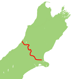
State Highway 1 is the longest and most significant road in the New Zealand road network, running the length of both main islands. It appears on road maps as SH 1 and on road signs as a white number 1 on a red shield, but it has the official designations SH 1N in the North Island, SH 1S in the South Island.

Waddington is a small village located in the Selwyn District of the Canterbury region of New Zealand's South Island, near the Waimakariri Gorge.

Mid Canterbury

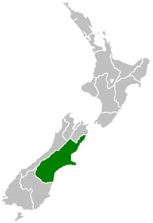
Mid Canterbury is a traditional, semi-official subregion of New Zealand's Canterbury Region extending inland from the Pacific coast to the Southern Alps. It is one of four traditional sub-regions of Canterbury, along with South Canterbury, North Canterbury, and Christchurch City.

Rakaia was a New Zealand parliamentary electorate in the Canterbury region from 1972 to 1978 and 1993 to 2008.

New Zealand State Highway 6 road in New Zealand

State Highway 6 is a major New Zealand state highway. It extends from the northeastern corner of the South Island across the top of the island, then down the length of the island, initially along the West Coast and then across the Southern Alps through inland Otago and finally across the Southland Plains to the island's south coast. Distances are measured from north to south.

New Zealand State Highway 3 road in New Zealand

State Highway 3 (SH 3) is one of New Zealand's eight national state highways. It serves the west coast of the country's North Island and forms a link between State Highway 1 and State Highway 2. Distances are measured from north to south.

New Zealand State Highway 2 road in New Zealand

State Highway 2 runs north–south through eastern parts of the North Island of New Zealand from the outskirts of Auckland to Wellington. It runs via Tauranga in the Bay of Plenty, Gisborne, and Napier and Hastings in Hawke's Bay. It is the second-longest highway in the North Island, after State Highway 1, which runs the length of both of the country's main islands.

New Zealand State Highway 73 road in New Zealand

State Highway 73 is a major east-west South Island state highway in New Zealand connecting Christchurch on the east coast with Cass/Hokitika via the Southern Alps. It is mostly two lane, with some single-lane bridges north of Springfield but is mostly dual carriageway in Christchurch. The fourth and fifth-highest points of New Zealand's state highway network are on this road at Porters Pass and Arthur's Pass respectively.

New Zealand State Highway 57 road in New Zealand

State Highway 57 is a New Zealand state highway, linking State Highway 1 north of Ohau to State Highway 3 east of Ashhurst, via Levin, Shannon, Massey University and the southern suburbs of Palmerston North. The highway connects State Highway 1 traffic coming north from Wellington to the city of Palmerston North, and further to the Manawatu Gorge, allowing passage to the eastern side of the North Island and to the twin cities of Napier and Hastings. The highway is classified by the NZTA as a national strategic road.

Ashburton River / Hakatere river in New Zealand

The Ashburton River / Hakatere is a river in the Canterbury Region of New Zealand, flowing across Mid Canterbury from the Southern Alps to the Pacific Ocean. The official name of the river was amended to become a dual name by the Ngai Tahu Claims Settlement Act 1998. It has been identified as an Important Bird Area by BirdLife International because it supports breeding colonies of the endangered black-billed gull.

State Highway 79 (SH 79) is a New Zealand state highway connecting the South Canterbury communities of Rangitata, Geraldine, and Fairlie. Starting at State Highway 1 the highway is 61 kilometres in length and runs in a general east-west direction. 6.3 km of the highway through Geraldine runs concurrently with the Inland Scenic Route, formerly State Highway 72. The road is a two-lane single carriageway, with a one-lane bridge crossing the Orari River.

Barrhill, New Zealand Village in Canterbury, New Zealand

Barrhill is a lightly populated locality in the Canterbury region of New Zealand's South Island. It is situated on the Canterbury Plains, on the right bank of the Rakaia River, about 17 kilometres (11 mi) inland from Rakaia. It was founded by Cathcart Wason in the mid-1870s and named by him after his old home Barrhill in South Ayrshire, Scotland. Wason set it up as a model village for the workers of his large sheep farm. The population of the village peaked in the mid-1880s before the general recession initiated a downturn for the village. Wason had expected for the Methven Branch railway to run past Barrhill, but the line was built in 1880 on an alignment many miles away, which caused Barrhill population to decrease.

References