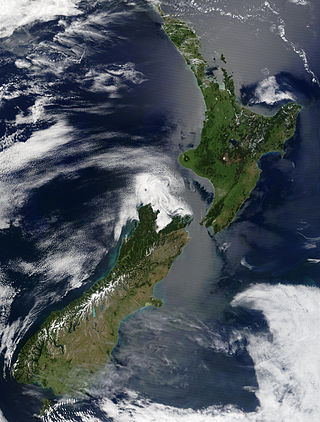
New Zealand is an island country located in the southwestern Pacific Ocean, near the centre of the water hemisphere. It consists of a large number of islands, estimated around 700, mainly remnants of a larger landmass now beneath the sea. The land masses by size are the South Island and the North Island, separated by the Cook Strait. The third-largest is Stewart Island / Rakiura, located 30 kilometres off the tip of the South Island across Foveaux Strait. Other islands are significantly smaller in area. The three largest islands stretch 1,600 kilometres across latitudes 35° to 47° south. New Zealand is the sixth-largest island country in the world, with a land size of 268,680 km2 (103,740 sq mi).

The Canterbury Plains are an area in New Zealand centred in the Mid Canterbury, to the south of the city of Christchurch in the Canterbury region. Their northern extremes are at the foot of the Hundalee Hills in the Hurunui District, and in the south they merge into the plains of North Otago beyond the Waitaki River. The smaller Amuri Plain forms a northern extension of the plains.

The Waimakariri River is one of the largest rivers in Canterbury, on the eastern coast of New Zealand's South Island. It flows for 151 kilometres (94 mi) in a generally southeastward direction from the Southern Alps across the Canterbury Plains to the Pacific Ocean.

Lake Ellesmere / Te Waihora is a broad, shallow coastal lake or waituna, in the Canterbury region of the South Island of New Zealand. It is directly to the west of Banks Peninsula, separated from the Pacific Ocean by the long, narrow, sandy Kaitorete Spit, or more correctly Kaitorete Barrier. It lies partially in extreme southeastern Selwyn District and partially in the southwestern extension of the former Banks Peninsula District, which now is a ward in the city of Christchurch. The lake holds high historical and cultural significance to the indigenous Māori population and the traditional Māori name Te Waihora, means spreading waters. It has officially had a dual English/Māori name since at least 1938.
Selwyn is a village in the Selwyn District of Canterbury, New Zealand. It was laid out in the 1860s for a population of 2,000 people, but it currently has very few houses.

The Selwyn River flows through the Selwyn District of Canterbury in the South Island of New Zealand.

Rakaia is a town sited on the southern banks of the Rakaia River on the Canterbury Plains in New Zealand's South Island, approximately 57 km south of Christchurch on State Highway 1 and the Main South Line. Immediately north of the township are New Zealand's longest road bridge and longest rail bridge, both of which cross the wide shingle beds of the braided river at this point. Both bridges are approximately 1,750 metres (5,740 ft) in length.

The Rangitata River is one of the braided rivers of the Canterbury Plains in southern New Zealand. It flows southeast for 120 kilometres (75 mi) from the Southern Alps, entering the Pacific Ocean 30 kilometres (19 mi) northeast of Timaru. The river has a catchment area of 1,773 square kilometres (685 sq mi), and a mean annual flow of 95 cubic metres per second (3,400 cu ft/s) at Klondyke.

The Ashley River is in the Canterbury region of New Zealand. It flows generally southeastwards for 65 kilometres (40 mi) before entering the Pacific Ocean at Waikuku Beach, Pegasus Bay north of Christchurch. The town of Rangiora is close to the south bank of the Ashley River. The river's official name was changed from Ashley River to the dual name Ashley River / Rakahuri by the Ngāi Tahu Claims Settlement Act 1998.

Selwyn District is a predominantly rural district in central Canterbury, on the east coast of New Zealand's South Island. It is named after the Selwyn River / Waikirikiri, which is in turn named after Bishop George Selwyn, the first Anglican bishop of New Zealand who, in 1843 and 1844, travelled the length of the country by horse, foot, boat and canoe, leaving in his wake a sprinkling of locations that now bear his name.

The Manawatū River is a major river of the lower North Island of New Zealand. The river flows from the Ruahine Ranges, through both the Manawatū Gorge and the city of Palmerston North, and across the Manawatū Plains to the Tasman Sea at Foxton.

Rolleston is the seat and largest town in the Selwyn District, in the Canterbury region of New Zealand's South Island. It is located on the Canterbury Plains 22 kilometres (14 mi) south-west of Christchurch, and is part of the wider Christchurch metropolitan area.

The Hurunui River is the fourth largest of the four principal rivers in north Canterbury, New Zealand, with a catchment area of 2,670 square kilometres (1,030 sq mi). The river flows from the eastern side of the Southern Alps, to the Pacific Ocean.

Environment Canterbury, frequently abbreviated to ECan, is the promotional name for the Canterbury Regional Council. It is the regional council for Canterbury, the largest region in the South Island of New Zealand. It is part of New Zealand's structure of local government.

Central Plains Water, or, more fully, the Central Plains Water Enhancement Scheme, is a large-scale proposal for water diversion, damming, reticulation and irrigation for the Central Plains of Canterbury, New Zealand. Construction started on the scheme in 2014.
This is a timeline of the Central Plains Water Enhancement Scheme.

The rivers of New Zealand are used for a variety of purposes and face a number of environmental issues. In the North Island's hill country they are deep, fast flowing and most are unnavigable. Many in the South Island are braided rivers. The navigable ones were used for mass transport in the country's early history.

The Ashburton River / Hakatere is a river in the Canterbury region of New Zealand, flowing across Mid Canterbury from the Southern Alps to the Pacific Ocean. The official name of the river was amended to become a dual name by the Ngāi Tahu Claims Settlement Act 1998. It has been identified as an Important Bird Area by BirdLife International because it supports breeding colonies of the endangered black-billed gull.

The Rakaia Bridge is New Zealand's longest road bridge and crosses the Rakaia River, one of Canterbury's large braided rivers. The present bridge was opened in 1939 and replaced an earlier combined road and rail bridge from 1873. The present road bridge is just downstream from the rail bridge and forms part of State Highway 1.
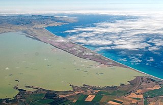
A waituna is a freshwater coastal lagoon on a mixed sand and gravel (MSG) beach, formed where a braided river meets a coastline affected by longshore drift. This type of waterbody is neither a true lake, lagoon nor estuary.


