Rakaia Bridge

Last updated

Rakaia Bridge
Rakaia River Bridge (State Highway 1) - 7300886734.jpg
Rakaia Bridge (State Highway 1) is New Zealand's longest road bridge
Coordinates 43°44′38″S172°02′16″E / 43.7440°S 172.0378°E / -43.7440; 172.0378
Carriesroad traffic
Crosses Rakaia River
Locale Canterbury
Other name(s)Rakaia Road Bridge
Named for Maori name of the river
Owner NZ Transport Agency
Characteristics
Designsimply supported reinforced concrete spans
MaterialConcrete
Total length1,756 m (5,762 ft)
Width6.2 m (20.5 ft)
No. of spans144
History
DesignerPublic Works Department
Constructed byRope Construction
Construction startMarch 1937
Inaugurated25 March 1939
Location
Rakaia Bridge

The Rakaia Bridge is New Zealand's longest road bridge and crosses the Rakaia River, one of Canterbury's large braided rivers. The present bridge was opened in 1939 and replaced an earlier combined road and rail bridge from 1873. The present road bridge is just downstream from the rail bridge and forms part of State Highway 1.

Contents

First bridge

The Canterbury Provincial Council decided in April 1864 to commence building the railway from Christchurch to Timaru. An engineer was engaged to undertake the design for the bridge over the Rakaia River and to proceed with construction immediately. Construction of the railway commenced, but there were problems with funding and the Rakaia Bridge was not started. [1] By the time the line reached Selwyn in October 1867, 35 kilometres (22 mi) from central Christchurch and just across the Selwyn River, the provincial government was so short of finances that construction was temporarily halted. The provincial government called for tenders for a road bridge over the Rakaia River and awarded the contract on 17 October 1869 to William White, who had earlier built a bridge over the Waimakariri River. White was to construct a timber bridge with 96 spans of 12.2 metres (40 ft) each. [2] Much of the timber was cut in Little River and barged across Lake Forsyth and Lake Ellesmere / Te Waihora. [3] Worked ceased in the following year when it was decided to make the bridge a combined one for both road and rail traffic. [2] A second contract was tendered and again won by William White. [4]

The Christchurch engineer William Bayley Bray (1812–1885) suggested that the spans could be reduced to 6.1 metres (20 ft), to which the provincial council agreed. John Blackett peer reviewed the plans on behalf of central government and recommended transverse joists and longitudinal planking. The contractor instead recommended transverse planking directly onto the girders with a 127 millimetres (5.0 in) asphalt cover, to which the provincial engineer agreed. The bridge was completed on 16 April 1873, but without the handrail being in place yet. [2] The formal opening of the bridge was on 29 May 1873 by the superintendent of the Canterbury Province, William Rolleston. All but four of the provincial councillors were present, plus a number of central government ministers and members of parliament, including William Reynolds (Commissioner of Customs), John Bathgate (Minister of Justice), Edward Stafford, William Montgomery, William Sefton Moorhouse, Leslie Lee, Hugh Murray-Aynsley, Walter Kennaway, Col De Renzie Brett, Henry Tancred, and Ernest Gray. [5] [6] The bridge cost NZ£36,196, [7] was 17 feet 3 inches (5.26 m) wide, and 4,480 feet (1,370 m) long. The rail was put down in broad gauge, 5 feet 3 inches (1,600 mm), as was the initial standard gauge in Canterbury. [6]

The results of the modified construction were devastating, and the planking flexed under the traffic load and dislodged the asphalt. [2] A Royal Commission found fault with all parties but laid most blame with the provincial engineer, and the bridge deck had to be rebuilt. [4] On this new deck, the rails were reduced to the New Zealand's uniform gauge of 3 feet 6 inches (1,070 mm). Just before reconstruction was complete, a major flood washed out both end of the bridge. [2] The bridge was subsequently lengthened (the portions that washed out were bunds that had been built within the braided riverbed) to 1,836 metres (6,024 ft) length with 224 spans of the two lengths referred to above. This bridge was used until March 1939. [2] The formal owner of the first bridge was the Railway Department. [8]

Current bridge

Minister of Public Works, Bob Semple, about to open the bridge Rakaia Bridge opening, 1939.jpg
Minister of Public Works, Bob Semple, about to open the bridge
Plaque from the 1939 opening Rakaia River Bridge (State Highway 1) 001.jpg
Plaque from the 1939 opening

In June 1931, the Railway Department informed the Main Highways Board that it would increase the charges for the Rakaia Bridge. This resulted in the Main Highways Board to start investigations for a new exclusive road bridge, which finished in March 1933. Some months later, negotiations were started for the Main Highways Board to buy the existing bridge for it to become an exclusive road bridge. Meanwhile, the Railway Department desired a new bridge as trains were getting heavier. [8]

In the end, the decision was made to build a new road bridge from reinforced concrete next to the existing bridge, and a railway bridge a short distance upstream. [9] One of the reasons for a new bridge was that the old one was considered too narrow. It regularly happened that two large vehicles would meet on the bridge and one had to back off the bridge again as they could not pass one another; not necessarily an easy or quick manoeuvre on a bridge about one mile long. [10] On other occasions, traffic was stuck behind a flock of sheep for as much as an hour. [11] The Main Highways Board proposed to recover some 12% of the construction cost from three adjacent counties: Ashburton, and Ellesmere. [12] In the end, the bridge was paid for from the Main Highway Fund in its entirety and the counties were relieved of their annual contribution towards the upkeep of the bridge. [3] [11]

After construction having started in March 1937, [3] the current bridge was opened on 25 March 1939 by the Minister of Public Works, Bob Semple. [11] Other speakers were the H. C. Harley of the Canterbury Automobile Association, whose organisation had organised the opening ceremony, and the local member of parliament, Arthur Grigg. [3]

The new bridge was designed by the Public Works Department under Fritz Langbein. The contractor was Rope Construction Company. [3] It has 144 spans of 40 feet (12 m), with a total length of 5,762 feet (1,756 m). [11]

The old Rakaia Bridge was last used by the Christchurch – Invercargill Express at 9.56 am on 12 December 1939. A mixed train coming from Ashburton was the first to pass over the new railway bridge at 12.30 pm on the same day; the new bridge was put into service without any ceremony. At 5,720 feet (1,740 m), it is New Zealand's longest rail bridge. [13]

Related Research Articles

<span class="mw-page-title-main">Ashburton, New Zealand</span> Town in Canterbury, New Zealand

Ashburton is a large town in the Canterbury Region, on the east coast of the South Island of New Zealand. The town is the seat of the Ashburton District. It is 85 kilometres (53 mi) south west of Christchurch and is sometimes regarded as a satellite town of Christchurch.

<span class="mw-page-title-main">Rail transport in New Zealand</span>

Rail transport in New Zealand is an integral part of New Zealand's transport network, with a nationwide network of 4,375.5 km (2,718.8 mi) of track linking most major cities in the North and South Islands, connected by inter-island rail and road ferries. Rail transport in New Zealand has a particular focus on bulk freight exports and imports, with 19 million net tonnes moved by rail annually, accounting for more than half of rail revenue.

Selwyn is a village in the Selwyn District of Canterbury, New Zealand. It was laid out in the 1860s for a population of 2,000 people, but it currently has very few houses.

<span class="mw-page-title-main">Rakaia River</span> River in Canterbury, New Zealand

The Rakaia River is in the Canterbury Plains in New Zealand's South Island. The Rakaia River is one of the largest braided rivers in New Zealand. The Rakaia River has a mean flow of 203 cubic metres per second (7,200 cu ft/s) and a mean annual seven-day low flow of 87 m3/s (3,100 cu ft/s). In the 1850s, European settlers named it the Cholmondeley River, but this name lapsed into disuse. The name Rakaia comes from Māori "Ō Rakaia", meaning the place where people were arranged by ranks.

<span class="mw-page-title-main">Ashley River / Rakahuri</span> River in New Zealand

The Ashley River is in the Canterbury region of New Zealand. It flows generally southeastwards for 65 kilometres (40 mi) before entering the Pacific Ocean at Waikuku Beach, Pegasus Bay north of Christchurch. The town of Rangiora is close to the south bank of the Ashley River. The river's official name was changed from Ashley River to the dual name Ashley River / Rakahuri by the Ngāi Tahu Claims Settlement Act 1998.

<span class="mw-page-title-main">South Island Main Trunk Railway</span> Railway in New Zealand

The Main North Line between Picton and Christchurch and the Main South Line between Lyttelton and Invercargill, running down the east coast of the South Island of New Zealand, are sometimes together referred to collectively as the South Island Main Trunk Railway (SIMT). Construction of a line running the length of the east coast began in the 1860s and was completed all the way from Picton to Invercargill in 1945; the last sections being on the Main North Line south of Picton. The designation "South Island Main Trunk" originally referred to only that line between Christchurch and Invercargill.

<span class="mw-page-title-main">Main South Line</span> Railway line in New Zealand

The Main South Line, sometimes referred to as part of the South Island Main Trunk Railway, is a railway line that runs north and south from Lyttelton in New Zealand through Christchurch and along the east coast of the South Island to Invercargill via Dunedin. It is one of the most important railway lines in New Zealand and was one of the first to be built, with construction commencing in the 1860s. At Christchurch, it connects with the Main North Line to Picton, the other part of the South Island Main Trunk.

The Methven Branch was a branch line railway that was part of New Zealand's national rail network in Canterbury. It opened in 1880 and operated until 1976.

<span class="mw-page-title-main">Canterbury Province</span> Provinces of New Zealand in South Island

The Canterbury Province was a province of New Zealand from 1853 until the abolition of provincial government in 1876. Its capital was Christchurch.

The Canterbury Provincial Railways was an early part of the railways of New Zealand. Built by the Canterbury Provincial government mainly to the broad gauge of 5 ft 3 in, the railway reached most of the Canterbury region by the time the province was abolished in 1876. Edward Dobson, the Provincial Engineer from 1854 to 1868, was the designer and overseer.

<span class="mw-page-title-main">Oxford Branch (New Zealand)</span>

The Oxford Branch was a branch line railway that formed part of New Zealand's national rail network. It was located in the Canterbury region of the South Island, and ran roughly parallel with the Eyreton Branch that was located some ten kilometres south. It opened to Oxford in 1875 and survived until 1959.

The Southbridge Branch was a branch line railway that formed part of New Zealand's national rail network. It was located in the Canterbury region of the South Island and operated from 1875 until 1967. Five kilometres of the line remains open as the Hornby Branch, formerly the Hornby Industrial Line.

<span class="mw-page-title-main">Christchurch railway station, New Zealand</span> Railway station in New Zealand

Christchurch railway station is in the Canterbury region of New Zealand's South Island. It is on the Main North Line at Addington junction, and is the only remaining passenger railway station in the city: suburban passenger trains were cancelled due to lack of demand in the 1970s. It is the terminus of the South Island's two remaining long-distance passenger trains, the Coastal Pacific to Picton and the TranzAlpine to Greymouth.

<span class="mw-page-title-main">Bridges in New Zealand</span>

The bridges in New Zealand are many and varied but only date back to the beginning of European settlement in the mid 19th century.

Ellesmere was a parliamentary electorate in the Canterbury region of New Zealand. It existed for two periods between 1861 and 1928 and was represented by six Members of Parliament.
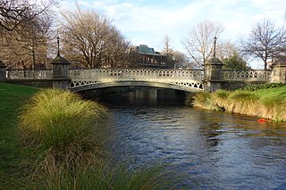
<span class="mw-page-title-main">Hamish Hay Bridge</span> Bridge in Christchurch, New Zealand

Hamish Hay Bridge is located in Victoria Square, Christchurch, New Zealand. Built in 1864, it was renamed in 1989 for Sir Hamish Hay, Mayor of Christchurch; a commemorative bronze plaque is affixed to the bridge's guard rail in the middle of the structure to honor Hay's services. The bridge, the oldest heritage feature in the square, is also the country's oldest cast iron and stone bridge. It survived the 2011 earthquake undamaged. Architectural features include the bridge arch and the balustrade's neo-gothic ornamentation. The bridge is registered as a Category II heritage structure with the New Zealand Historic Places Trust.

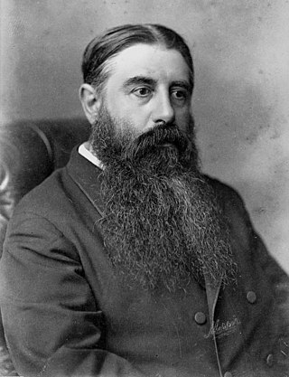
John Anderson was a Scottish-born New Zealand engineer. He played rugby union for West of Scotland during his time in Scotland for his education and represented Scotland internationally. He lived in New Zealand from infancy and together with his brother, took over his father's company. The company flourished under their guidance and became one of New Zealand's largest builder of bridges for roads and rail.

<span class="mw-page-title-main">The Vogel Era</span> History of New Zealand between 1873 and 1876

The Vogel Era describes the history of New Zealand between 1873 and 1876, when the country adopted an immigration and public works scheme inaugurated by the colonial treasurer, then premier, Julius Vogel to develop the country and to relieve the slump of the late 1860s; to be financed by borrowing overseas. His "Great Public Works Policy" resulted in a large increase in migrants and provision of many new railways, roads and telegraph lines. The railway system developed from a few lines in three gauges to the start of a national network including the main line from Christchurch to Dunedin, though the narrow "Cape gauge" required later upgrading to increase the restricted height and weight limits.

<span class="mw-page-title-main">Armagh Street Bridge</span> Bridge in Victoria Square, New Zealand

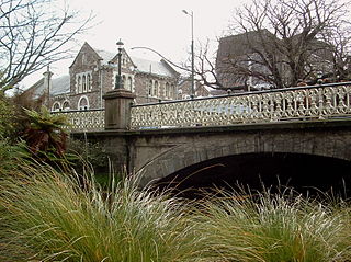
The Armagh Street Bridge is a historic bridge on Armagh Street in Christchurch Central City. It sits between the Convention Centre Precinct and the Magistrate's Court at the south-west corner of Victoria Square. Its initial importance was it making a connection to the Canterbury Provincial Council Buildings just beyond the Magistrate's Court.

References

  1. "Building the Rakaia Railway Bridge". The New Zealand Railways Magazine. 6 (1). Wellington: New Zealand Government Railways Department: 51f. 1 May 1931.
  2. 1 2 3 4 5 6 Thornton, Geoffrey (2001). Bridging the Gap: Early Bridges in New Zealand 1830–1939. Auckland: Reed Publishing Ltd. pp. 21f.
  3. 1 2 3 4 5 "Opened for Traffic". Ellesmere Guardian. Vol. LX, no. 24. 28 March 1939. p. 5. Retrieved 13 April 2015.
  4. 1 2 "Report of the Rakaia Bridge Commission". The Press . Vol. XXIII, no. 3059. 11 June 1875. p. 3. Retrieved 12 April 2015.
  5. "Opening of the Rakaia Bridge". The Press . Vol. XXI, no. 2439. 30 May 1873. p. 2. Retrieved 12 April 2015.
  6. 1 2 "Opening of the Rakaia Bridge". The Star . No. 1642. 30 May 1873. p. 2. Retrieved 12 April 2015.
  7. "Christchurch". The Evening Post . Vol. XI, no. 87. 11 June 1875. p. 2. Retrieved 12 April 2015.
  8. 1 2 "Bridging Plans". The Evening Post . Vol. CXX, no. 109. 4 November 1935. p. 10. Retrieved 13 April 2015.
  9. "Two New Bridges". The Press . Vol. LXXI, no. 22256. 2 November 1935. p. 15. Retrieved 13 April 2015.
  10. "Traffic Blockage". Ellesmere Guardian. Vol. LVIII, no. 70. 3 September 1937. p. 2. Retrieved 13 April 2015.
  11. 1 2 3 4 "Rakaia Bridge". The Evening Post . Vol. CXXVII, no. 71. 25 March 1939. p. 11. Retrieved 13 April 2015.
  12. "New Rakaia Bridge". The Press . Vol. LXXI, no. 21623. 6 November 1935. p. 10. Retrieved 13 April 2015.
  13. "Longest in Dominion". The Evening Post . Vol. CXXVIII, no. 141. 12 December 1939. p. 11. Retrieved 13 April 2015.