Canterbury | |
---|---|
![]() Canterbury Province within New Zealand post 1868 | |
Country | New Zealand |
Island | South Island |
Established | 1853 |
Abolished | 1876 |
Named for | Canterbury, England |
Seat | Christchurch |
Population (1875 [1] ) | |
• Province | 71,316 |
The Canterbury Province was a province of New Zealand from 1853 until the abolition of provincial government in 1876. Its capital was Christchurch.
Canterbury was founded in December 1850 by the Canterbury Association of influential Englishmen associated with the Church of England. (An attempt was initially made to restrict residence in the province to members of the church but this was abandoned.) [1] The Charlotte Jane and the Randolph —the first two of the First Four Ships—arrived in the area on 16 December 1850, later celebrated as the province's Anniversary Day. [2]
In 1852, the Parliament of the United Kingdom passed the New Zealand Constitution Act 1852, which amongst other things established provincial councils. The Constitution contained specific provisions for the Canterbury Association; the first being that the new General Assembly (New Zealand Parliament) could not amend the legislation establishing the Canterbury Association, [3] the second being that the Canterbury Association could hand its powers to a newly established provincial government (the Canterbury Province). [4]
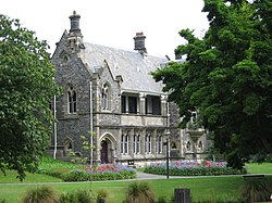
Elections were held in 1853 for Superintendent and, later that year, for the 12-member council. These elections predated any elected national assembly. The franchise was extended to men over the age of 21 who owned property in the province. As a result, affairs of the Canterbury Association were wound up in 1855 and outstanding settlement lands handed over to the Canterbury Province. [5] The first meeting place was the former office of the Guardian and Advertiser, Canterbury's second newspaper, on Chester Street near the Avon River. In 1866, the council moved to Guise Brittan's house, which later became part of the Clarendon Hotel. One session in 1858 was held in the town hall on what is now High Street; the town hall was in the section north of Lichfield Street. On 28 September 1859, the council first met in what became known as the Timber Chamber of the Canterbury Provincial Council Buildings. The Stone Chamber of the Provincial Council Buildings was used from November 1865. [6]
Following the West Coast gold rush, the portion of the province west of the Southern Alps was split off as Westland in 1867. Upon the establishment of the University of New Zealand in 1870, its Christchurch campus housed the system's headquarters. [1]
On the east coast the province was bounded by the Hurunui River in the north and the Waitaki River in the south. The boundary on the west coast was largely undefined before the West Coast became its own province.
In 1868 the West Coast was separated from the Province with the formation of the County of Westland on the West Coast with the boundary line defined as the crest of the Southern Alps. In 1873 the County formed its own Province, the short-lived Westland Province.
In the south the course of the Waitaki River was not known and disputes arose with the Province of Otago over pastoral leases in the inland high country. [7]
In the 1860s South Canterbury made two bids to become separate province but this was rejected by the national government. Instead in 1867 the General Assembly created the Timaru and Gladstone Board of Works which received a proportion of the Canterbury provincial land revenues and was authorised to maintain and build the Timaru harbour and local roads and bridges.
When the province was abolished, the area was distributed across eight counties. [8]
The Ferrymead Railway was the first railway to be opened (1863) and closed (1868) in New Zealand. [9] It was made obsolete by the opening of a new 8 miles (13 km) line through a tunnel giving Christchurch access to the better port of Lyttelton. [1] The mainlines of the Canterbury Provincial Railways were Irish gauge (5 feet 3 inches or 1.60 meters) with some branch lines in Colonial gauge (3 feet 6 inches or 1.07 meters). [1] These lines were all eventually absorbed into the New Zealand Railways Department in 1876.
Charles Simeon was the returning officer for the first election of a Superintendent. The nomination meeting was held at the Christchurch Land Office (the site now occupied by Our City), and there were three polling stations: in Christchurch at the Resident Magistrate's Court, in Lyttelton at the Resident Magistrate's Court, and in Akaroa. [10]
Canterbury had four Superintendents: [11]
No | from | to | Superintendent |
---|---|---|---|
1 | 20 Jul 1853 | Oct 1857 | James FitzGerald |
2 | 24 Oct 1857 | Feb 1863 | William Sefton Moorhouse |
3 | Mar 1863 | May 1866 | Samuel Bealey |
30 May 1866 | May 1868 | William Sefton Moorhouse (2nd time) | |
4 | 22 May 1868 | 1 Jan 1877 | William Rolleston |
The Executive Council is comparable to a cabinet. The following 26 Executive Councils existed: [12]
Each New Zealand province celebrates an anniversary day. Canterbury Province's was originally 16 December, the day of the 1850 arrival of the Charlotte Jane and the Randolph . [2] Since 1862, an A&P (Agricultural and Pastoral) show has been held annually. Its Friday Show Day was set for many years on the People's Day[ clarification needed ] and, sometime in the late 1950s, the Christchurch City Council moved the province's Anniversary Day to coincide with the show and encourage greater crowds. The holiday is presently defined as the "second Friday after the first Tuesday in November", ensuring that it will follow the Melbourne Cup Racing Carnival. [14] This adjustment is observed in northern and middle Canterbury; southern Canterbury instead observes its Anniversary Day on Dominion Day (the 4th Monday in September). [14] [15]
The archives of Canterbury Province are held at Archives New Zealand's Christchurch office, and are some of the most complete provincial New Zealand government archives in existence. In 2023, these archives were inscribed on the UNESCO New Zealand Memory of the World Register. [16]
The South Island is the largest of the three major islands of New Zealand in surface area, the others being the smaller but more populous North Island and sparsely populated Stewart Island. It is bordered to the north by Cook Strait, to the west by the Tasman Sea, to the south by the Foveaux Strait and Southern Ocean, and to the east by the Pacific Ocean. The South Island covers 150,437 square kilometres (58,084 sq mi), making it the world's 12th-largest island, constituting 56% of New Zealand's land area. At low altitudes, it has an oceanic climate. The major centres are Christchurch, with a metropolitan population of 521,881, and the smaller Dunedin. The economy relies on agriculture, fishing, tourism, and general manufacturing and services.
The provinces of the Colony of New Zealand existed as a form of sub-national government. Initially established in 1846 when New Zealand was a Crown colony without responsible government, two provinces were first created. Each province had its own legislative council and governor. With the passing of the New Zealand Constitution Act 1852 the provinces were recreated around the six planned settlements or "colonies". By 1873 the number of provinces had increased to nine, but they had become less isolated from each other and demands for centralised government arose. In 1875 the New Zealand Parliament decided to abolish the provincial governments, and they came to an end in November 1876. They were superseded by counties, which were later replaced by territorial authorities.
Christ's College, Canterbury is an independent Anglican secondary day and boarding school for boys, located in the city centre of Christchurch, New Zealand.
William Sefton Moorhouse was a British-born New Zealand politician. He was the second Superintendent of Canterbury Province.
James Edward FitzGerald was a New Zealand politician. According to some historians, he should be considered the country's first premier, although a more conventional view is that neither he nor his successor should properly be given that title. He was a notable campaigner for New Zealand self-governance. He was the first Superintendent of the Canterbury Province.
The Bridle Path is a steep shared-use track that traverses the northern rim of the Lyttelton volcano connecting the port of Lyttelton with the city of Christchurch in the South Island of New Zealand. It is a popular walking and mountain biking route. The track ascends from the port itself to a height of 333 metres (1,093 ft) before descending again via Heathcote Valley to Christchurch. At the summit, next to the Summit Road, is a stone shelter with covered seats that is a 1940 New Zealand centennial memorial to the Pioneer Women of Canterbury. There are also seven commemorative stone seats placed along the Bridle Path; most of these were built for the 1950 Canterbury centenary celebrations.
The Canterbury Association was formed in 1848 in England by members of parliament, peers, and Anglican church leaders, to establish a colony in New Zealand. The settlement was to be called Canterbury, with its capital to be known as Christchurch. Organised emigration started in 1850 and the colony was established on the South Island. The First Four Ships took out settlers steeped in the region's history. The Association was not a financial success for the founding members and the organisation was wound up in 1855.
Nelson Province was constituted in 1853 under the New Zealand Constitution Act 1852, and originally covered the entire upper South Island, including all of present-day Buller, Kaikoura, Marlborough, and Tasman districts, along with Nelson City, Grey District north of the Grey River, and the Hurunui District north of the Hurunui River. It was reduced in size by the creation of Marlborough Province in November 1859, then abolished in 1876, along with all the provinces of New Zealand.
The Otago Province was a province of New Zealand until the abolition of provincial government in 1876. The capital of the province was Dunedin. Southland Province split from Otago in 1861, but became part of the province again in 1870.
The Canterbury Provincial Railways was an early part of the railways of New Zealand. Built by the Canterbury Provincial government mainly to the broad gauge of 5 ft 3 in, the railway reached most of the Canterbury region by the time the province was abolished in 1876. Edward Dobson, the Provincial Engineer from 1854 to 1868, was the designer and overseer.
The Lyttelton Rail Tunnel, initially called the Moorhouse Tunnel, links the city of Christchurch with the port of Lyttelton in the Canterbury region of New Zealand's South Island. It is the country's oldest operational rail tunnel, and is on the Lyttelton Line, one of the first railways built by Canterbury Provincial Railways.
Edward Dobson was Provincial Engineer for Canterbury Province, New Zealand from 1854 to 1868.
Sir Arthur Dudley Dobson was a New Zealand surveyor, engineer and explorer. Born in London, he came to Lyttelton, New Zealand, in 1850 on one of the First Four Ships. He is best known for taking the first party of Europeans over Arthur's Pass.
Superintendent was the elected head of each Provincial Council in New Zealand from 1853 to 1876.
James Townsend was an English wine merchant, who in later life was a pioneer settler in New Zealand's South Island. He was also an amateur cricketer.
The Lyttelton Times was the first newspaper in Canterbury, New Zealand, publishing the first edition in January 1851. It was established by the Canterbury Association as part of its planned settlement of Canterbury and developed into a liberal, at the time sometimes seen as radical, newspaper. A successor paper, The Star, is published as a free bi-weekly newspaper.
Joseph Brittan was a New Zealand surgeon, newspaper editor, and provincial councillor, was one of the dominant figures in early Christchurch. Born into a middle-class family in southern England, he followed his younger brother Guise Brittan to Christchurch, where he and his wife arrived in February 1852 with four children. Joseph Brittan soon got involved in the usual activities of early settlers and gained prominence in doing so. He had bought 100 acres on 10 July 1851 and took up 50 of this to the east of Christchurch that he converted to farmland. There, he built the family residence, and the suburb of Linwood was subsequently named after Brittan's farm and homestead of Linwood House.
Lieutenant-Colonel James Campbell was a lieutenant-colonel of the British army who distinguished himself in the Peninsular War. He emigrated to New Zealand and was appointed as a land commissioner, and later as Registrar of Deeds, in Canterbury.
Richard James Strachan Harman was trained as a civil engineer. However, in Christchurch, New Zealand, he worked as a bureaucrat, politician and businessman. He was one of the Canterbury Pilgrims, having arrived in Lyttelton, on Sir George Seymour, one of the First Four Ships. He was a business partner of Edward Cephas John Stevens and senior partner of Harman and Stevens, and together they took financial control of the Christchurch newspaper The Press from its original proprietor, James FitzGerald, over a protracted period. Harman held many important roles with the Canterbury Provincial Council and was the last Deputy-Superintendent.
Sir Walter Kennaway was a provincial politician, farmer and run-holder in Canterbury, New Zealand, before becoming secretary to the Agent-General in London for 35 years.